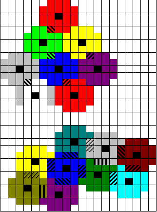
Just count the tiles, and you should see the pattern. You can go about it two ways, I guess.
1. Easiest way: From the capital, go three tiles east, then either 1 tile north or south. Then for the town to the west you would go the opposite direction (if your eastern town had gone 1 tile south, then the western town would go 1 tile north).
2. What I had done: From the capital go 4 tiles southwest, then 2 tiles northwest for one city and 3 tiles southeast for the other city. In the other dirction (4 tiles to the northeast), you would flip-flop the two (2 tiles southeast, and 3 tiles northwest).
Since the pattern keeps repeating, you can just visualize any city as the capital to place future cities. Doing some drawing on graph paper helps you see the pattern easier.
Just keep in mind this is only a good pattern in theory, not necessarily in reality. By placing cities in a consistant pattern, you may end up with cities 1 tile from a river, 1 tile off of a coast, in poor terrain that doesn't have enough food (mountains/hills), etc. Also, you don't get benefits from placing cities directly on some bonus resources (food bonuses), like you did in the original version, so that would lessen the practicality of this if cities end up being built on certain resources.
I'm thinking of adjusting this site to also explain/show ICS (very dense build) city placement.


