D&D mod: tjedge1-Mystara

Would you be interested in a D&D mod?

  • Yes!

    Votes: 186 84.5%
  • No way!

    Votes: 3 1.4%
  • Not really sure.

    Votes: 13 5.9%
  • What is D&D?

    Votes: 18 8.2%

  • Total voters
    220
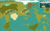
Why do u choose 275 x 225 ? it seems easier for me to make a 256 x 256 (cause of the little soft who only accept specific sized bitmap)

Also, for many people, large map size means good hardware ressources, at least when u take into account the # of civ

By looking at the map that i've cropped, i find that there is a good part which will be absolutely not useful (as you certainly block x and y wrapping i presume) : the Bellisarian sea


Originally posted by tjedge1
Here is a little more what I was needing for the scenario map. You don't have to go so far past the Savage Coast, or as far south as the map shows, but I would like the rest of the map in. I just posted a little extra on the West and South in case you had room on the map. I like your maps so far, and I think I need to find out what this map utitlity you are using. Could be real handy in my later mods.
:hmm: Let me crop it again and see if it fits. Maybe it's too long to show.
:suicide: :wallbash: :p :rolleyes: Maybe if I spelled it right, I wouldn't have had to upload it twice. Well here is what I need.

wowmodmap1.jpg


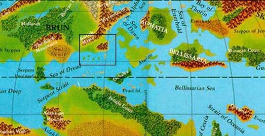
EDIT: You know now that I think about it. Maybe not so far east into Skothar and so far south as the Izonda coast. Let me know if you have any questions.
 

Attachments

  • tiedge1project-cropped_once.jpg
    tiedge1project-cropped_once.jpg
    13.6 KB · Views: 345
Here is the basis for the full world map.

i had to distort the mercator projection to have something rectangular ...

A question, rather interesting.

Do u know the origin of this map. What does TSR staff used for making it. Look carefully, in fact it's nearly obvious
 

Attachments

  • mystara-worldmap-copy.jpg
    mystara-worldmap-copy.jpg
    13.6 KB · Views: 344
I always thought Pangea maps were interesting, and I would be surprised if there weren't more fantasy worlds based on those. I know Tolkien based the 'Third Age' maps of Middle-earth on Northwestern Europe, but the resemblance is definitely not as striking as in Mystara. :)
 
I think Mystara might have been a Pangea style before Blackmoor almost blew it up. From what I remember the climat egot warmer and the seas rose up a little. The Serpent Penninsula was once a lush forest if I recall.

@Arghis: The world map that you posted was drawn up years back by TSR. Not sure who the actual artist is, but every map made since is based off that one. The copy I have is from the Rules Cyclopedia for the Challenger version of D&D. Mystara kinda fell away with Advanced D&D and was only partially converted to the new rules. A big loss to me. It was too much to convert after I had pretty much mapped out and designed the rest of the uncovered world on my own, I was not about to convert it all on my own. As far as an origin? I think they based the continents on the real Earth. Except they merged Africa and S.America, and squeezed the Asian region down a little.

About the cropping of the odd shaped map. If it is easier to use the version you posted that will be fine. That still has all the important parts. Brun and Alphatia was the most important regions anyway. That will do and give more room in Brun as well. I want to get as many of the nations as possible in there that I can and still take care of the rest. The scenario civ list will be something like this. 256x256 will be fine.

Alphatian Empire will include:
Alphatia
Norwold (north)
Thothia

Thyatian Empire (and allies):
Thyatis
Glantri
Karameikos
Heldann
Norwold (south)

Non aligned:
Hule
Darokin
Ethengar
Alfhiem
Graakhalia (the underground civ in the Great Wste)
Five Shires
Ieriendi
Minrothad
Ostland
Ylaruam
Rockhome
Vestland
Soderfjord Jarldoms
Thar
Sind
Atruaghin Clans
Ulimwengu
Yavdlom
Kastelios (including Davania city-states)
Hinterland tribes
Jen
Savage Coast
Denagoth

I'll set up something to simualate the war Hule started at this time as well. It could be a messy scenario.

@Isak: That is a good city list for Glantri, thanks.
 
Originally posted by tjedge1

@Arghis: ... It was too much to convert after I had pretty much mapped out and designed the rest of the uncovered world on my own, I was not about to convert it all on my own.
you really map all the mystara world map ?


As far as an origin? I think they based the continents on the real Earth. Except they merged Africa and S.America, and squeezed the Asian region down a little.
you're right, but they do not merge Afrr ans South Am. , it was just like this long, long ago


About the cropping of the odd shaped map. If it is easier to use the version you posted that will be fine. ...

As u like.


256x256 will be fine.

ok
 
Originally posted by Arghis
you really map all the mystara world map ?

Yes. When I was in Junior high I spent one summer just drawing out the maps and fleshing them out with nations. Most were wild barbaric type tribes and large regions of land ruled by monsters. I even had a Minotaur nation I designed based on the one from Dragonlance books I had read. I finished it years later as my players actually began living in Davania and they helped many nations there defeat Thyatis and force them off the shores and then to help stop the Return of Alphaks. That is an adventure I designed myself, but I can't seem to find what I did with it. He had come back form his second defeat in Norwald and moved to the Vulcan penninsula and enslaved the population there and then began making an army of undead. Anyway, that was years ago and has nothing to do with the mod. I'm rambling. It is drawn out on many many many sheets of hex paper. I redrew the maps from the gazeteers that I had and then just started working my way out. There is one online that is pretty good. I can't remember where though, but somebody made one that covered most of the world. I made Davania a little wilder than Brun and Skothar.

BTW: Don't worry about the terrain for now. I am going to upload the graphix I would like to use so you can map off that. I am going to try combining different graphix from different mods that I have. I found a Mars terrain that might solve the problem for the Great Waste and Broken Lands. I'll try to get to that tonight and post it sometime tomorrow.
 
Originally posted by tjedge1
I think Mystara might have been a Pangea style before Blackmoor almost blew it up. From what I remember the climat egot warmer and the seas rose up a little. The Serpent Penninsula was once a lush forest if I recall.
:o 
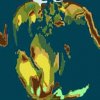
Don't know why I wrote 'Pangea' - i meant Pre-historic, but yeah the image probably set me into thinking about continental drift and that sort of thing. I think you're right about Blackmoor being the cause of the continental drift on Mystara :)

It is drawn out on many many many sheets of hex paper. I redrew the maps from the gazeteers that I had and then just started working my way out. There is one online that is pretty good. I can't remember where though, but somebody made one that covered most of the world.
I think you must mean this guy's maps. They are pretty impressive too.

Your campaign sounds like it was interesting. I'm not even going to start off with the campaigns I've led players through in Mystara. Maybe we should all three just leave Civ3 and start on a Neverwinter Nights Mystara mod instead :D

...just kidding.

Edit: A bit of grammar and spelling corrected.
 
BTW Arghis: I liked those destroyed cites and goodyhuts. I have the chasm as LM Mountains, but I don't know if I want to use them for this mod. I will certainly in my Wheel of Time mod. The terrain buildings file you gave me is missing the row with barricades. That wouldn't be the one from PTW is it? Don't worry, I liked it, but it needs updating, for instance I need to copy and paste over the modern buildings. I'll take care of that, that's easy enough for me. Back to work on those terrain graphix and I'll update you soon.
 
well, here is what it looks like for Thyatis (Heldann Freehold included) (with Sind, Wendar, Denagoth at the frontier) for map2 project.

i've put cities for having a better idea of distance (and perhaps playability)

i've also kept major fortess (if i put every one, it's fortress land particularly around ethengar. lol.)

i've put lakes (3), cause i think they're important (either graphically or tactically)

Thar is just a mountain with barb camp

i think it's an interesting beginning.
 

Attachments

  • mystara-map2-basic-thyatis.jpg
    mystara-map2-basic-thyatis.jpg
    45.3 KB · Views: 380
I like it so far. I have had problems with trying to combine terrain graphix from different mods. The mars terrain I got works, but looks to cartoony for what I was actually trying to do. I'll figure this out yet though. Maybe harder than I had thought. I'll upload the graphix I have so far for actual terrain maybe later today if I can get to my pc.
 
I have had problems with the terrains so far. I tried to convert some of the files from Balrog's Fantasy Empires, but it isn't working. I cut the Kraal forest and pasted it over the LM Forest tiles and now I get the forest, but it is surrounded by magenta patterns overlapping everywhere. That doesn't make since to me. Anyone know how to take a screen shot in the editor? I don't have the actual game cd on this pc or I would do that. I know how to get a screen shot from there.

I also redrew the green lines between each tile. That wouldn't be a problem would it? When I didn't the tiles I pasted wouldn't even show up and only the default LM Forest terrain was showing. This is the only LM terrain I'm having trouble with so far.
 
@Arghis: Just wanted you to know I have failed at making my own terrain so I'm going to use Rhye's. The files you added were good as well so you can work with Rhye's terrain and don't worry about the LM terrains. I'll just rename them, but they'll still be the same in graphix. Except LM Mountains. Use the original LM graphix for those so we have brown and grey mountains. The brown would be good for Broken Lands or something. They might not look the same but they can act the same as Broken Lands.

Other than that this is what terrains should be renamed.
LM Plains---------Steppes
LM Forests-------Ancient Forest (I liked that idea)
LM Desert--------Burning Lands (Like where Graakhalia is)
LM Sea------------Lake (to put in the inner lakes that are big enough)
LM Mountains----Broken Lands
LM Hills------------not sure on this either. Was thinking of an edit of this somehow. I'll look into replacing this with another hill terrain that is different, but still fits.

That Mars terrain idea didn't work out at all.

You don't have to download any of this terrain if you don't want. I alreay have and will include it in the mod when it's ready to be posted.

The holiday's are drawing closer and as soon as they are over, I will be working very hard to finish this mod and get it posted. Thanx for the help so far.


@Isak: I never thought of a text file city list. That worked great and made it easy to just copy and paste it in. :goodjob:
 
This is a list of all the civs I might be using. Not sure on all though. Included is a description of what they are.

Aengmok - The Shadow Elf kingdom after they poisoned Alfhiem and gained control of it during the war of wrath.
Alfhiem - The elven kingdom surrouned by Darokin.
Alphatia - A great Empire ruled by magicians
Atruaghin - A native american style civ ruled by clan chiefs.
Brasol - A less warlike Dwarven civ, aggression replaced with even more greed.
Darokin - A trading civ run by a plutocracy. Money decides whose in charge.
Denagoth - An isolated civ north of Wendar.
Doria - The elven kingdom that sprang up after the demise of Alfhiem and ruled by the same rulers as Alfhiem was.
Ethengar - A horseman civ ruled by a Great Kahn.
Five Shires - A halfling land in southern Brun.
Frosthaven - A civ ruled by Giants in the far north.(non-playable)
Glantri - A slavery infested and monster filled kingdom ruled by mages.
Graakhalia - An underground kingdom of elves and gnolls in the Great Waste.
Heldann - A group of colonies by great heroes who are trying to become rulers on their own.
High Shire - The homeland of the halflings deep in the Mountains and forests of Davania.
Hinterland Tribes - The 4 tribes of northern Davania jungles.
Hule - A great kingdom ruled by a mysterious and evil ruler, bent on world domination.
Ieriendi - Island kingdom that allows pirates to base on their land.
Izonda - A great kingdom of Davania, ruled by Amazons and populated by elves, dwarves and halflings as well.
Jen - The most prominant alliance of tribes on Skothar.
Karameikos - A mercanary kindom that was once free and now ruled by a Thyatian Duke.
Kastelios - The strongest city-state in north Davania.
Malpheggi - A tribe of reptiles that worships the gods of the Temple of the Frog.
Minrothad - A sea kingdom of elves and men who are quite serious about stopping piracy.
Nithia - A kingdom of dead that was wiped away long ago, leaving Ylaruam and Thothia.
Norwold - A land of civil war in which Alphatia and Thyatis are usually behind.
Ostland - The stereo-typical Viking nation.
Rockhome - The militant home of the Dwarves of Brun.
Savage Coast - The baronies and city-states of the coastal region south of Hule. Also the home of a the rare Cinnabar.
Sind - The civ of the Great Waste that was first conquered by Hule in the War of Wrath.
Soderfjord Jarldoms - A group of jarldoms that join together in times of need.
Tanagoro - A great kingdom of explorers in Skothar.
Thar - The strongest kingdom of goblinoids in Brun.
Thothia - The original rulers of the Isle of Dawn
Thyatis - A empire in the same manner as Rome. And just as hungry for new land.
Traladara - The nation that was devastated and conquered by Karamiekos.
Ulimwengu - An isolated nation that prefers to stay out of the worlds problems.
Vestland - Another viking style kingdom with more concern over commerce than pillage.
Vulcan - A former great kingdom of men that has been conquered and now ruled by an undead king and his army of minions.
Wendar - The greatest elven kingdom in Mystara.
Yavdlom - A kingdom of dark skinned half elves.
Yazak - The orc tribes of the Immortal arm and Yazak steppes.
Ylaruam - The arabic style nation just north of Thyatis. A land once ruled by Nithia.


Not all of these will be in every mod of course. These are just the ones I've decided on so far. If there are any more that anyone can think of and should include just let me know. I'm trying to get a few more not in the Known World so I can spread out the civs for the world map.
 
Here is the same list in relation to where they are in Mystara:
The continent of Brun
Aengmok
Alfhiem
Atruaghin
Darokin
Denagoth
Doria
Ethengar
Five Shires
Glantri
Graakhalia
Heldann
Hule
Karamiekos
Nithia (also on the western region of the Isle of Dawn)
Norwold
Rockhome
Savage Coast
Sind
Soderfjord Jarldoms
Thar
Thyatis
Traladara
Ulimwengu
Vestland
Wendar
Yazak (could be moved to northeast Skothar)
Ylaruam

The continent of Skothar
Jen
Tanagoro

The continent of Davania
Brasol
High Shire
Hinterland Tribes
Izonda
Kastelios
Malpheggi
Vulcan

The small continent of Alphatia
Alphatia

The Isle of Dawn small continent
Thothia

The islands around Brun
Frosthaven
Ieriendi
Minrothad
Ostland
Yavdlom

As you can see, Brun is a major concern for over-population. Most of those will not be in the world map, but most will be in the Known world map and scenario map.
 
Back
Top Bottom