- Joined
- Mar 17, 2007
- Messages
- 9,345
Sounds like a silly question, but I've realized it is used in cases other than the obvious case. To quote a fairly informative guide, which I'd thought was accurate in this regard until recently, when I noticed what appeared to be deltarivers.pcx in use away from deltas when looking closely.
I was looking into deltaRivers.pcx tonight, and in my experiments, found that some of this description doesn't appear to be fully accurate. I'm wondering if any of the resident experts can fill in some details.
What I did was add a scenario search folder to a randomly-generated map in the Firaxis editor, and add only the deltaRivers.pcx from Balthasar's Winter Terrain set to the appropriate art folder, leaving mtnRivers.pcx as the default. This made it easy to tell when it was using deltaRivers.pcx, and when it wasn't.
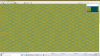
After looking around the random map, I saw deltaRivers.pcx being used in most areas, so I created a non-random section, which looks like this:

It appears that deltaRivers is always used next to desert (thus becoming flood plains; the flood plains graphics are also visible), but in other areas there's a pattern to when it's used, and when it isn't. But the pattern occasionally changes.
I spent enough time trying to figure out the rhythm for forests and mountains back in the day to not try to solve it for these. Still, my searches didn't turn up much definitive, a bit surprising since I would have expected some posts over the years about trying to combine deltaRivers from one pack for the deltas with mtnRivers from another pack, and noticing some differences like this.
Anyone else ever notice this? I thought I knew which parts of terrain generation were random, but it would seem otherwise...
Next, you get the rivers and resources.pcx applied on. The rivers are applied on the edges of tiles, and if there are mountains involved, have waterfall graphics. If it passes next to a desert tile, it applies the floodplain.pcx graphic over the desert tile, and if it exits to water, it applies the deltaRivers.pcx file.
I was looking into deltaRivers.pcx tonight, and in my experiments, found that some of this description doesn't appear to be fully accurate. I'm wondering if any of the resident experts can fill in some details.
What I did was add a scenario search folder to a randomly-generated map in the Firaxis editor, and add only the deltaRivers.pcx from Balthasar's Winter Terrain set to the appropriate art folder, leaving mtnRivers.pcx as the default. This made it easy to tell when it was using deltaRivers.pcx, and when it wasn't.
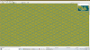
After looking around the random map, I saw deltaRivers.pcx being used in most areas, so I created a non-random section, which looks like this:
It appears that deltaRivers is always used next to desert (thus becoming flood plains; the flood plains graphics are also visible), but in other areas there's a pattern to when it's used, and when it isn't. But the pattern occasionally changes.
I spent enough time trying to figure out the rhythm for forests and mountains back in the day to not try to solve it for these. Still, my searches didn't turn up much definitive, a bit surprising since I would have expected some posts over the years about trying to combine deltaRivers from one pack for the deltas with mtnRivers from another pack, and noticing some differences like this.
Anyone else ever notice this? I thought I knew which parts of terrain generation were random, but it would seem otherwise...