archontophoenix
Chieftain
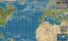
I've noticed that lots of people create Earth maps, but complain that it's difficult to get the relative sizes and shapes of the landmasses correct. I thought it might be helpful to start from actual satellite images with the correct relative areas, and I found some images like that at http://www.evl.uic.edu/pape/data/Earth/.
Here's a Java-language utility for creating BTS Earth maps from some of those images (the images are included in the zip file):
http://forums.civfanatics.com/uploads/54867/Image2MapBeyond.zip
The maps include no bonuses, just terrain. The resulting map is intended to be edited by hand in order to make a genuinely playable scenario.
The numeric parameters in the program err in favor of water rather than land at coastlines, so peninsulas often wind up too skinny and islands often disappear. Terrain types and forest cover are based on the colors of the maps used, which are sometimes misleading (sometimes there's ice on tropical coastlines, for example). You can fix these problems with hand editing.
Apologies for not making this a normal map script in Python, but I'm much more fluent in Java than Python. Perhaps someone will be ambitious enough to do the translation...