Here's a map I've been working on, based on the pangaea shown in the Animal Planet mini-series, "Future is Wild". This is a map based on 200 million years into the future.
How did I make this? For those who want to know how a map can be made...
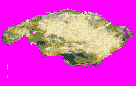
I went to the Animal Planet website and looked at the Future is Wild page. They had a video with the pangaea map. I took a screenshot of it, cropped it, then reduced it to 16 colors. I got rid of the ocean colors, and made it pink temporarily. Then, I was left with 9 base colors (just the right amount for land tiles). In order to get the bmp2bic util to work, I had to temporarily resize the canvas (i.e., from 256x183 -- not the correct measurements BTW -- to 256x256). Remember, this program only works on vanilla Civ3 sizes. Once saved, I opened the Civ3 editor, and "configured" the bmp for a scenario. By that, I mean this:
When you save the bmp2bic file, the graphics are very choppy (they look like your old console video game tiles - 1 graphic each for grass, water, etc.). I had to select grassland, and click a few grassland tiles, then move the scrollbar. It takes awhile sometimes.
Then, I saved it, and imported it into C3C, and then cropped the image (F12). Now, the tundra is going to be turned into marshland, since bmp2bic didn't have marshes (only tundra). There's also the issue with the mis-labeled palette that it uses for forest and jungle, which I'll have to redo the whole thing.")
Anyway, here's a preview.
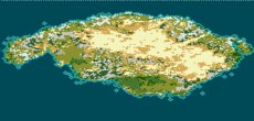
False Topography map:
How did I make this? For those who want to know how a map can be made...
I went to the Animal Planet website and looked at the Future is Wild page. They had a video with the pangaea map. I took a screenshot of it, cropped it, then reduced it to 16 colors. I got rid of the ocean colors, and made it pink temporarily. Then, I was left with 9 base colors (just the right amount for land tiles). In order to get the bmp2bic util to work, I had to temporarily resize the canvas (i.e., from 256x183 -- not the correct measurements BTW -- to 256x256). Remember, this program only works on vanilla Civ3 sizes. Once saved, I opened the Civ3 editor, and "configured" the bmp for a scenario. By that, I mean this:
When you save the bmp2bic file, the graphics are very choppy (they look like your old console video game tiles - 1 graphic each for grass, water, etc.). I had to select grassland, and click a few grassland tiles, then move the scrollbar. It takes awhile sometimes.
Then, I saved it, and imported it into C3C, and then cropped the image (F12). Now, the tundra is going to be turned into marshland, since bmp2bic didn't have marshes (only tundra). There's also the issue with the mis-labeled palette that it uses for forest and jungle, which I'll have to redo the whole thing.
Anyway, here's a preview.
False Topography map:

") I do know that the western side had what looked like a huge river.
I do know that the western side had what looked like a huge river.

 I love that series! All I want is the finished map, I don't need the squid things.