I have spoken with Laskaris about this both in PM and in some of these discussions. If all goes well he won't have nearly the amount of work in order to accomplish this. Our goal (assuming he agrees with my proposal I recently sent him) is to use his map to test and perfect the climate engine, thus having the engine create the C2C version of the Earth map. If all goes well, the only changes that will need to be made to the resulting map are placements that arise from the random element in the engine (i.e. placement of specific vegetation and bonuses).
I don't mean to be a naysayer, but I'm not sure that any climate engine we can come up with could model all the local climates to the leve of detail that my 232 x 112 plot map has. Even with the Global Climate Models that run on supercomputers, they have trouble getting the small-scale, local climates right. Granted, we aren't trying to program an actual Global Climate Model, with vertical atmospheric cells, deep ocean currents and so on, but something more simple and straightforward. Still, expecting the climate engine to create an accurate model of Earth, in all the details, is probably too ambitious a goal.
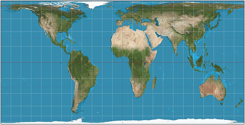
I agree that using my map to make the engine as good as we can make it might be a good idea, but this raises another issue: the question of map projections. I use a cylindrical equal-area projection for my Gigantic Accurate Earth Map, with standard parallels at 37.3 degrees north and south of the equator. I think there is a lot to be said for using equal-area projections of a planetary surface in Civilization. Cities and the plots they occupy are in many ways the core of the game, so depicting landmasses with their accurate areas is important. Distortions of distance, on the other hand, are not that bad because distance is rather abstracted in Civilization, anyway (armies that take 20 years to reach their destination? yeah right!).
The equal-area projection is a pretty complex one, though, and might not be the best one for the various GeoRealism engines to work on. So, assuming that you want to use an equal-area projection as the final result, you have two choices:
1) Let the GeoRealism engines work with maps that are already in an equal-area projection, meaning that the lines of latitude are not evenly spaced - there is a large space between the equator and 10 degrees latitude, but a much smaller one between 80 degrees latitude and the pole, and so forth:
Or, 2) Let the GeoRealism engine work an another map projection that is more well-suited for straightforward mathematics, like an equirectangular projection where all the latitudes are evenly spaced out, and then convert the map into an equal-area projection in a separate operation afterwards.
And if you don't want to use an equal-area projection at all, then 3) My map is of no use to you, anyway.
")
