Inter-City Roads

Junglecutter

Honorable Delegate
Joined
Apr 1, 2006
Messages
341
Location
Singapore
Propossed Inter-City Road Map - Version 2.00


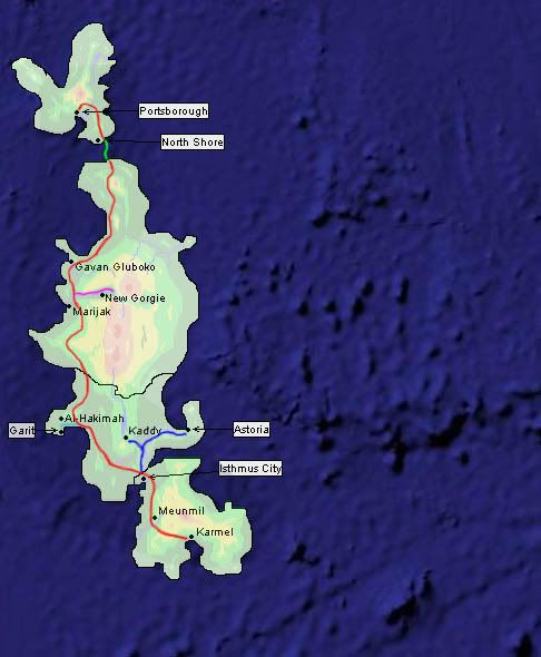
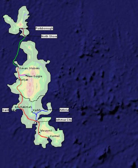
(Roads are based on construction on the easiest local terrain)

Suggested Map by Provolution w/ ferry from Gevan


Names are not important at this time(though brainstorming some now will save time later)

Feel free to suggest alternate routes.:)
 
Great work Junglecutter.

I will vote for this one, but it would be wise to add an interstate road to Astoria just in case, and a normal highway going through Al Kaminah through Kaddy by the Lake and to Astoria. Besides, we need an updated map with Kaddy, as West36 added.
 
@Provolution


I can't find an updated map though, an there is already a highway to Astoria(Blue)
 
Oh, I see, the provincial interstate follow the river, gotcha.

Astoria is now down to 2 MPs anyways, just letting you know.

If only Splime would be so kind to make the updated map. He is the best on maps of us.
 
I'll remove Novoe Vladivostok then, if no one else can...
 
Good call Splime, need to reinstall a decent graphics program here.

Kaddy is also your party member West36's latest contribution.
 
Currently, NoVlad is abandoned, but I am strongly in favor of there being a city there. I mean, river mouth... come on.


Where exactly is Kaddy?
 
We can see if we can direct a new MP to set up a town there.

Would be good with a Russian town there, a natural place for a good town.
Besides, Northern Province needs more representation.
 
Just to be sure, that green one is a ferry right? Because it shouldn't be a bridge, if we want one of those we should have to build it ourselves.
 
Kaddy is just south of the great lake, Winters Lake, John called it. Kaddy is also mentioned on page 9 in Map discussion and registry, your original map thread.

A sort of Russian town that was ceded away in 1854.

I will put up the interstate Isthmus-Karmel for a vote in the Southern Province thread.
 
Oh, I think North Shore should have a direct ferry to Gavan, and the road go from there. This is by far the most economic solution. The Northern Cape is merely wilderness, and no highway should go through there. That ferry trip is 312 KM long, and would take about a day to travel, which means Cook Island is quite independent in many ways. The preferred means of travel from Cook would be by air.
 
Khadyzhenskaya is on Page 9 in the Map discussion thread, as Provolution said.
But I'm not sure if the the name "Winters Lake" agrees with that kind of name.
 
The lake was named by someone from Astoria, the man/boy that made the topographic map, including that lake.
 
I guess now that he left the game, you may surely change it.

At least for the south, we tried to agree on the major landmarks, so set up a Central Province naming thread like North and South did, and make proposals.

If enough MPs in your province agrees, these names are official.

But you are right, that lake belong to the central province.
 
That ferry trip is 312 KM long, and would take about a day to travel, which means Cook Island is quite independent in many ways.

Err... Google Earth tells me the following approximate measurements for the width of that channel:

25.11 km
15.60 miles
13.56 nautical miles
14,755.63 smoots (I have no clue what a smoot is... :lol: )

Therefore, Cook Island is fairly close. A bridge/tunnel system is feasible for such a distance. (Example: The [wiki]Chesapeake Bay Bridge-Tunnel[/wiki] is 23 miles long.)
 
I think that's with the 'new' ferry to Marijak...without the road going to nowhere but the top coast.
 
Well, the ferry would ideally suited be a joint vote of Cook Island and Northern Province, since you all depend on it and so on for trade. Options could be:

North Shore-Gavan ferry
North Shore-Marijak ferry
North Shore-Northern Point Ferry

For the tunnel-bridge, that has to be built later, as we are a small economy.
 
When I said Marijak, I meant Gavan.... My bad.

Though, on the other side, a ferry could conceivably go to Portsborough as well. It depends on what they want to do.
 
Top Bottom