Lough Neagh, Ireland - 392 km2 - 1 tile
Lake Balaton, Hungary - 592 km2 - 2 tiles (because of it's shape), should be changed to 1?
Lake Ferto / Neusiedlersee, Hungary - 315 km2 - not present
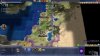
Dead Sea, Levant - 600 km2 - 1 tile currently, change it to 2? (if Balaton remains 2)
Galilee Sea, Levant - 166 km2 - probably it's better to leave it out
Lake Tuz, Anatolia - 1600 km2 - 1 tile, should be more probably
Lake Egirdir, Anatolia - 482 km2 - 1 tile
Lake Beysehir, Anatolia - 650 km2 - 1 tile
Lake Garda, Italy - 370 km2 - 1 tile
Lake Geneva, Switzerland/France - 581 km2 - 1 tile
Lake Constance / Bodensee, Switzerland/Austria - 541 km2 - 1 tile
Lake Scutari / Skadar, Balkans - 370-530 km2 - 1 tile
Lake Ohrid - 358 km2, Balkans - 1 tile, represented together with Prespa
Lake Prespa - 259 km2, Balkans - represented together with Ohrid
Lake Vattern - 1912 km2, Sweden - 2 tiles
Lake Vanern - 5650 km2, Sweden - 3 tiles
Lake Malaren - 1140 km2, Sweden - 2 tiles
Lake Hjalmaren - 483 km2, Sweden - represented together with Malaren
Lake Storsjon - 464 km2, Sweden - 1 tile
Lake Peipus - 3555 km2, Estonia/Novgorod - 3 tiles
Lake Onega - 9700 km2, Russia - 4 tiles
Lake Ilmen - 982 km2, Novgorod - 1 tile
Lake Beloye - 1130 km2, Russia - 1 tile
Lake Ladoga - 17700 km2, Russia - 8 tiles
Lake Saimaa - 4400 km2, Finland - currently represented by a series of lakes (because of it's shape)
Lake Paijanne - 1080 km2, Finland - currently represented by multiple lakes
Limfjord in Denmark - not actually a lake, will be changed to salt lake or coast
There are a couple other lakes in Finland and Russia not mentioned here.
Swarbs is right, Sea of Galilee is much smaller than any of the other lakes we currently have.
I also don't think a lake should be represented if it's much less than 4-500 km2.
")

") ) so I don't think we need that much water in what is quite an arid area.
) so I don't think we need that much water in what is quite an arid area.