merijn_v1
Black Belt
Don't get me wrong, I do really like the larger map proposal. I gives a lot of new opportunities. But adding only a few columns to the current map just for Arabia isn't worth the effort.
Sorry I don't see a better place for this. Any support for moving the English city from Exeter to Bristol in the 1200 scenario? Makes the naval game a bit more challenging.
I am very excited for 2.0, and a larger map.
Until then, I think the game would be improved by expanding the map 5-10 tiles to the east, as this would make more room for the Arabs, and make Trebizond viable. Expanding to the east is easy, compared to expanding to the west, which would require all coordinates to shift.
What do you think?
I see your point about Arabia, but personally I would like to see the map expand to include all of Eastern Europe, up to the Urals and the west edge of the Caspian. That would also have the advantage of including Baghdad, Mosul, Trebizond and other cities which were not part of Europe, but did play an important role in the region as a whole.
That would help make the AI Arabs more threatening and viable than they are at the moment, and would avoid the need for excessive revolt mechanics in Jerusalem, as the Arabs could respond to Crusades with their own armies built on a much stronger economic base. It would also make the Seljuks and Mongols more threatening, as rather than spawn a few units at a time in Anatolia and European Russia they could spawn en masse in Iran and the Ural passes and sweep west
Also in the long term we could add Georgia which was an important influence on Eastern Europe at the time and possibly the Golden Horde and Seljuks as playable civs.
Of course I understand this is going to be a lot of work (and I won't be able to do it!) so happy to wait until you guys feel you are in a position to make such a major addition.
I agree generally, that was one of the main reasons for my 2.0 project.
Still, I don't want to start such huge changes on the main mod.
If I ever get into it, it will be for the RFCE 2.x series, with a much more carefully planned map from the start.

Is there any chance that 2.0's map could include the entirety of Scandinavia? Please?
Not too much.
The shape is more or less given.
Also, there is no real need for those territories, there was little to no populace there during the timeline of the mod.
And most importantly, the further we go north, the harder it is to make any map-projection appealing enough.
")
Most good new computers could easily handle a xtra-large map. Mine could probably handle 250X300, but I digress.
Would the 2.0 map at least go a little farther north?
Most good new computers could easily handle a xtra-large map. Mine could probably handle 250X300, but I digress.
Would the 2.0 map at least go a little farther north?
First of all: Why do you want to go further north?
What do you want to represent there from the medieval history of Europe?
Also how do you balance those territories' shape and size? (and again, this is the most important thing)
If you go up that north, either the shape or the size will be way too much distorted IMO, no matter what projection you use.
I've experienced that as well. Norway even settles Scotland when I played England and killed off the Scottish.
Norway never goes for Iceland, though. Maybe an automatic spawn of a settler somewhere in between the years of 960 and 1060 would help. That would also prevent the exploit of a non-Viking human building Vinland because I presume Norway would build it sooner or later then.
I noticed that the Andalusia province is almost 50% of Iberia. Maybe break down the province into 3 peaces.
The problem is that RFCEurope has sufficient granularity where some small islands (like Malta) can be added as land tiles, while other small islands are best suited as 'features' on water tiles, and I'm not sure where the dividing line is or should be. We could simply keep all the existing island tiles and add the new feature around those, but I get the sense part of the reason for including the island feature in the first place is to get rid of all those one-tile sites that never amount to much.
There should obviously be a salt lake near Jerusalem, to represent the Dead Sea.
There are also two major salt lakes in eastern Spain, near Torrevieja & La Mata.
I also found a endorheic/salt lake in eastern Turkey (Lake Van), but I don't think that'd fit on the map. The same applies to the Caspian Sea and the Aral Sea, neither of which appear in the map area.
No idea where to put fresh water lakes -- frankly, I'd suggest replacing any one-tile seas in the current map with fresh water lakes, unless there's a good reason why a specific tile should't be replaced.
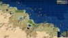
For reefs, there should be one or two in the Skerki Channel between Sicily and Tunisia, as well as one northwest of Tunisia to represent the Sorelle Rocks. There's also the Sha'b Abu Nuhas reef in the northern part of the Red Sea.
Per Wikipedia, there's also coral reefs in the North Sea, a bit northeast of Scotland, as well as another west of North Africa (either in the far southwestern corner of the map or outside the map area entirely).
I'm not entirely pleased by this, because every resource I could find seemed to be focusing on coral reefs as ecological habitats, rather than as naval hazards that we're looking for.
The problem is that RFCEurope has sufficient granularity where some small islands (like Malta) can be added as land tiles, while other small islands are best suited as 'features' on water tiles, and I'm not sure where the dividing line is or should be. We could simply keep all the existing island tiles and add the new feature around those, but I get the sense part of the reason for including the island feature in the first place is to get rid of all those one-tile sites that never amount to much.
True, there is no clear line. We will probably decide on a case by cases basis.However, in the 'Suggestions and Requests' thread, I proposed adding the following islands or island groups:
- Along the eastern coastline of the Adriatic, especially near Ragusa
- Near Nantes and the western coast of France
- Both north and west of Scotland, as well as the Isle of Man
- Along the western coastline of Norway
- Near Amsterdam and the Heligoland Bight
- Near Copenhagen and the sea between Denmark and Scandanavia
- Scattered throughout the Aegean Sea
- Between Corsica and mainland Italy
Yeah, more or less that was my initial plan for it.For semidesert, I'd be inclined to just add it between the plains and desert in North Africa and the Middle East, and outright replace any desert tiles in the rest of Europe with the new semideserts. Use that as your new baseline, then adjust as necessary.
No reefs are present on the map ATM.
Most of those can be added probably.
But yeah, I'm mainly looking for naval hazards, even if there are not that much around Europe.