Marla's Map, Scipio Modification Edition IV

Joined
Nov 27, 2001
Messages
582
Location
Denver CO, United States of America
The Scipio Modification - Edition IV
--------------------------------------
Based from Marla's Map v1.05
--------------------------------------

NOTE:You must Right Click and Save Target

Download here: Scipio Map Modification Edition IV (67k)

*Modifications in Edition IV *
-------------------------------

I cannot attach things to this post so please scroll down for a mini-map picture of the Edition IV world.

Europe
---------
Europe Has once again been resized. As a consequence Northern Africa has been shortened but still represent a realistic proportion.

-Spain now has the Cantabrian Mts. and Sierra Morena Range placed. This means spain has a lot more hills but still represents an excellent place to settle.

-The area around france has been expanded and should now offer more options for new settlements.

-Italy has been expanded to offer more room (but a cramped one) for additional cities.

-Sicily has been remodeled and offers more room for setllement.

-Greece has been remodeled and is now much more realistically represented.

-The Tagus, Guadalquivir, Douro, and Ebro rivers of Spain have all been reset for a more realistic placement.

-Denmark has been moved more West and is now more realistic in appearence.

-The German area has been expanded.

-Sweden and Norway have been remodeled. They are shorter then i'd like but still the same length as before, just moved somewhat north.

-The Mountain range on Norway/Sweden (I forget its name) has been remodled for a more realistic setting. This means that some tundra, and hills have been placed on the Western shores of Norway to make this area a place one can place cities, but still is accurate to the mountain range of that region.

-The Kola Peninsula has been enlarged to represent its real size.

-Iceland has been remodeled to obtain a mroe realistic shape. It is now closer to Greenland by neccesity rather realism.

-England has been remodeled and is now a little bit more bigger. It unfortunatly is a little to close to norway and iceland but is more realistic in proportion to Europe I beleive.

-All these modifications to Europe were made to improve gameplay as well as improve the accuracy of hte map in these regions. Unfortunatly I can't make norway or sweden as big is they are in a vertical manner, but they still look good on the map. Europe now is preportioned more realistically, in my opinion, to the rest of the world then it was before.


Asia Minor/Middle East
----------------------------

-Turkey has been increased in size and now has a better placement of the Toros Baglari range.

-The connection between africa and the Arabian peninsula has been reduced in size for a more realistic impression of the size of this area.

-The dead sea has been placed though it just appears as a little tiny river in a corner next to the two saltpeter. This is because the Dead Sea is a major producer of salt and saltpeter.


Africa
----------

- North Africa has been reshaped to be a little more realistic as ell as providing area for Europe to expand into. It still is proportionate to the rest of the world.


North America
------------------

-Mexico has been expanded to be mroe realistic in size adn shape.

-The Baja peninsula has been moved and is more realistic in placement.

-The Sierra Madre Occidental and Oriental have both been remodeled for realism.

-The Start location and shape of the area around Washington D.C. has been changed to make the location and area be mroe realistic.


If you might notice a lot of changes have been made for realism . These are all neccessary and practical changes in my opinion, and I think represent a better earth with more accurate proportions and precise palcement of terrain. This map is still far from being 100% realistic but I think its getting a lot closer now. I'll post pictures in the next posts.
 
There a quite a few things that I don't particulary like about this map...but it is certainly one of the better MAPS...

1. Why is New Zealand the major producer of Aluminium for the world...this makes absolutely no sense at all! At present Australia is the main producer followed by Guinea/Brazil and then Jamaica...

2. The Mediterrean for playability purposes could do with being less crushed whilst the Sahara need not be so massive!

3. Enough coal in the mountains of scotland to supply an entire civ...no...the Caledonian mountains of scotland are composed of METAMORPHIC from LONG before the Carboniferous...no coal to play with there...Coal mining in Scotland is more located in the Lowlands...

If you believe Britain justifies a second coal resource then locate it in either the NE of England (county durham) or in the middle of in the Pennines (which isn't well represented on your map due to England being pretty small).

4. Japan...her coal and iron supplies were insufficent...she was VERY reliant on foreign import...consider japan is formed due to a subduction zone and you'll realise that the likelihood of much coal formation being present as rather unlikely.

Manchuria was a primary target for japan to forfill her need of iron ore and coal for her industrialisation...

5. Basically the map would be improved if Europe was given more room at the expense of Africa as human civilisation (in civving terms) certainly is most active here.


I'll leave it at that as my primary suggestions...don't take it hard, I think your work is EXTREMELY GOOD :goodjob:


Can't wait to see edition 3 :)
 
Thanks for the suggestions Kitten and i'll be sure to consider them for the map when I make my next set of modifications. Though I think all of them have merit, I don't think however, I can satisfy each one without comprimising the playability of the map. And I'm always a bit hesitent to change its look, which I consider to be its best attribute.

The late response has been due to the Medal of Honor: Allied Assault demo which has consumed the greater part of my gaming/free time of recent. Otherwise thanks for the critique's and i'll be sure to take each at their value :).
 
One thing, I just got a chance to take a glance at the map and your suggestions and I realised I forgot to make my original modifications to resource allocation (in Edition I) to New Zealend. Thats why it was so abundent there. Sorry to everyone, I apologize for this mistake and will, in its wake, release one last Marla's Map, Scipio Modification to fix this problem and increase gameplay for those who want it. A problem has arrised, I am not able to release a mod version using Marla's map. I am not able make some of the modificataions I want for my mod proper without a v1.06 map. Unfortunatly my older maps (ones pre-existent to my HD before patching the game) have not and will not convert to v1.06 when I use the CivEditor. So I'll have to make my own :(. If someone has a suggestion as to how to patch my maps it would save me a lot of effort and time. Just putting another shot in the dark out there in hopes someone will see it with my answer.
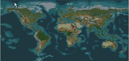
 
Mini-Map Picture
 

Attachments

  • scipiomapmodivpic.jpg
    scipiomapmodivpic.jpg
    17.4 KB · Views: 3,162
Here's a picture of the map in the mini map from Scipio Map Modification Edition IV.
 

Attachments

  • scipiomapmodivpic.jpg
    scipiomapmodivpic.jpg
    17.4 KB · Views: 3,459
Scipio, you need to put these various editions of your map in one thread. When you release a new version, simply delete the old version of the file and upload a new one in the same post/thread. It'd be very confusing if every map maker open a new thread for each new version of the map.

Please read the files forum usage FAQ for more info:

http://forums.civfanatics.com/announcement.php?s=&forumid=52
 
Understood and apologies about starting the new thread. I'll try and follow the proper protocal now that I know. Thanks for merging my thread with the previous whoever did so.
 
Noted about the Uranium mine near Quebec, but I just wanna make sure I can find it on a reliable map source first before I implement it. :)

I would like people who live in specific regions to give me ideas for improving the map or of course and hope more people will write back with suggestions and comments. I've seem to have a lack of those :). That may be due to the few downlaoding of my maps and the case that its a modification of another one, but I do feel this is an excellent modification this time round, providing teh bigger but still excellent looking Europe.


One thing i'd like to note is that unfortunatly the NB map with less barbarians has a mistake in which the extra saltpeter isn't present in N. America. I'll try and fix the NB up and but a new one up sooner rather then later, but my definition of sooner is loose. So write please, i'm intrested most in critique's that you feel reduces gameplay, falters in realism, or any other qualm you seem to have. Of course an encouraging word here or there might be nice. :)
 
I like your modifications to Marla's map. That's why I used it (v2) as the base for my Realistic Starting Nations scenario. Trust you to change it again! ;)

Have you seen the modifications I made to the oceans, seas and coasts, and my reasoning for it in the scenario?

One important point regarding barbarians. I discovered in the rules editor that on all levels except deity, the player gets a massive combat bonus against barbarians, for example 200% on regent and 800% on cheiftan!

So the solution may not be to place more barbarians, but to reduce the bonuses to make them more effective. I've changed the bonus to 0% for regent on up, and just 100% on warlord and 200% on cheiftan.

Paul
 
Hey scorpio, magnificent map!

But there is one mistake I noticed, in the area of Israel, above the red sea, instead of desert you putted mountains! it should be all desert there, its the negev desert, and it just where the 3 green mountain tiles you putted.

hope you can fix that :)

Still, Great map! :goodjob:

And, 2 tiles above these mountains, one tile right, put a snowy mountain (mount hermon) which takes place in the border of syria and Israel, and it is snowy at winter and green at summer. and below it put some more grassland, the golan is green and not plain, but these are all thins, and they dont really matter, I just noticed that because I live in israel.
good job with the map :)
 
One more thing:
In the east border of Israel you forgot to put the dead sea, just put one dot of sea there and 2 tiles of saltpepper around it, because its a MAJOR source of salt for the entire world.
just a suggestion
 
and also like to thank kitten for her helpful suggestions. Enjoy!

HER :confused: I'm a kitten that likes to chase the birds ;)
 
Well thanks for all the replies all. :)

To Ice, thanks for the suggestions about the area around the dead sea and Isreal. I find that often the people who live in specific regiosn know the best about em'. I'll be sure to apply your suggestions in the next mod.

To Paul, I haven't actually downloaded your scenario but will be sure to do it ASAP. Thanks for using my mod as your base and will look for some of those modifications made in your own map for my next edition. :)

To Kitten, well all I can say is ooooops, I should learn to take a pass on assumptions.

And lastly to Akilles, don't worry. They'll be some uranium by Quebec in short order.

Note: The Edition III NB map has been updated, though the name is the same. It contains the Saltpeter in N.America now as well as a few modifications suggested by IceBlaze and Akilles. However, I have yet to look over Pauls map so that will have to be Part of Edition IV. :)

I'm intrested in any more suggestions for my moded map and further modifications to the game itself. I was planning on creating some Manufactured goods such as textiles and electronic components but I can't require city improvements for resources! Wouldn't it be great to be able to build 7 factories to be able to produce textiles or 5 factories and 5 research labs for electronic components. Could be a great balance for industrialized countries with little luxeries against less developed countries with plenty of resources. Anyways I have more under the table, and other things planned, just not sure if I can accomplish all of them with the limited editor and my small computer knowledge. Oh well, thanks again all.
 
Originally posted by Scipio Africanu
To Paul, I haven't actually downloaded your scenario but will be sure to do it ASAP. Thanks for using my mod as your base and will look for some of those modifications made in your own map for my next edition. :)

It's mainly just the water features that I changed, and after playtesting I've realised I need to add a strip of sea around all the coasts. Ocean right next to coast doesn't work very well.

The modifications I made to Asia/Alaska and Greenland were just to create a bit of a gap on each side of America to stop civs reaching there too early in the game. The gaps aren't strictly realistic so it's up to you if you want to include those, but the shapes are slightly better because they're less stretched.

I added more barbs to North America, increased them from roaming to restless and removed the player attack bonuses. I may have overdone it because I'm having an awful lot of combat out there. (Still there's no-else to fight at the moment, the other civs are being very slow in moving out there.)

Paul
 
As far as the Dead Sea, here is my suggestion. Since the Dead Sea is only 394 sq. miles, I don't think it deserves a full square. Here is my reasoning... The Great Salt Lake in Utah, U.S.A. is 1,600 sq. miles and it is only represented by one square.

Some details are just too small to try and represent in the limited abilities of the map editor and to keep the map in proportion.

Here's a suggestion to solve it, though it's tricky, use the river overlay, and if you put it in one corner of a square, it shows up as what looks to be a little lake. I was able to do it, after several tries. Sometimes if you don't put it in the right spot, it hooks up with the Tigris and Euphrates Rivers, though.

I tried giving the Dead Sea one full square, but it just didn't look right, and really made a mess of the map.

As far as resources, I would find some reference that gives you just the MAJOR sources of them, because there are alot of countries that supply at least some of them. And find some balance between the reality of major sources and what is needed for the sake of gameplay.

In the 1999 TIME almanac it lists that Greenland has natural resources of iron, coal, and uranium, this would not justify giving Greenland all those resources in this game, however.
 
Originally posted by Bamspeedy
Some details are just too small to try and represent in the limited abilities of the map editor and to keep the map in proportion.

Which begs the question, should every little island be represented? They may look pretty but could they really support the kind of populations we see in the game? I'd tend to think not in many cases.

Take Ascension Island for example, it's strategically important but only has a population of about 1000. It's primarily just a military base and little else.

On Marla's map Wales is represented by just two squares, so a one square island is actually half the size of Wales, that's pretty damn big.

I think larger islands and groups of small islands should qualify, but probably not the very small ones, unless they're in a very important strategic position.

Paul
 
Alright, i'd like to address some of the suggestions made of recent.

Firstly, I agree that the dead sea should only be represented by the river lake thing. I've had some problems getting it done but it shouldn't be much of a problem. However I have found that they only form lake's when near mountains and hills which could be a problem with the flat terrain around there.

As for resource allocation, most of the resources you see present are fairly large contributers to national or international trade and stockpiles in that region. I gathered this information from the 2000 New York Times Almanac. However in some areas some resources have to be allocated for gameplay balance alone. Though I would like to make it is realistic as possible, it is a fine line between ruining and increasing gameplay because of it. If I had made these resources demand of a depth of say 10,000 tons per resource the map would be significantly reduced and gameplay could be destroyed. I have made it about for the capacity of 6,000 tons of the sed designated resource for a bi-annual (6 months. This does not mean they produce this much, just have the cpaacity to do so) for each resource. However the Aluminum in Europe, Iron in New Zealend, Some Uranium sources in Europe, and a few oil deposits in Russia and the one in Norway have all been added for balance issues. They do represent sources of each resource, but not nearly enough for the 6,000 tons per bi-annual. Soem resources are present merely because they were very significant taps of each resource in the past. Becasue we can't use them today, doesn't mean they weren't significant resources in the past. I appreciate your concern and suggestions, and I will review my resource allocation, but in my opinion I believe the resources are properly distrubited.

As for the isalnds, I agree some of them are represented by to much land for their size. However these are relics from the original map by Marla of which I have yet to scrutinize. I will most definatly do so in the near future and thank you for your opinion.

I hope this doesn't sound rude or brash in any manner but I am entitled to my own position :). I'd like to thank you all for your concerns and constructive criticism and will evaluate each request and see how it may effect gameplay. Thanks again.
 
Top Bottom