Lamabreeder
Chieftain
- Joined
- May 11, 2004
- Messages
- 54
Introduction
Spain. The year is 1031. The Caliphate of Cordoba has been formally dissolved. The once glorious empire is split into numerous small kingdoms, the so-called Taifas, who are fighting amongst themselves as much as against the slowly rising Christian kingdoms in the north and in the east, in the shadows of the Pyrenees.
Taking on the leadership of one of the Taifas, can you create a greater destiny and reunite the lands of the Moors under the flags of your house? Or can you, leading one of the Christian kingdoms, seize the day and carry on the Reconquista, the reconquest of the lost lands, taking the Muslim Taifas one by one? In, let's say, less than four and half centuries?
You will play on a 40x40 tiles map wich loads and plays very fast despite the relatively high number of civilizations (18). Standard rules are in effect. Gamespeed is Marathon to stay longer in medieval times and to have cheaper troops as opposed to buildings.
Playable civilizations are the five Taifas Cordoba, Sevilla, Granada, Valencia and Majorca, and the five kingdoms of Leon, Castille, Navarra, Portugal and Aragon. On the map present but not playable are France, the Almoravids, Badajoz, Toledo, Zaragoza, Silves, Cartagena and Almeria. The last six are minor civilizations and always at war with everybody.
What's this?
Attached to this post is a zip file containing a number of maps. This includes next to the main scenario the base map and some "free play" settings on said map. A detailed list:
Installation
Unzip the attached file in a directory of your choice. Move those files you want in either your WorldBuilder directory (most likely C:\Documents and Settings\My Computer\My Documents\My Games\Beyond the Sword\Saves\WorldBuilder) or, probably better, in your public maps directory (most likely C:\Documents and Settings\My Computer\My Documents\My Games\Beyond the Sword\PublicMaps). Delete the downloaded file and any extracted file unused. Note that Civ4 may not find the new files immediately if you do this while Civ is running.
A word on the map
The map represents a portion of earth almost exactly from 10° west to 5° east and 35° north to 45° north as depicted in Akademische Verlagsanstalt, "Peters Atlas", 1989.
The transformation to a 40x40 tiles grid is, of course, not without loss of information and imprecision. I have tried to be mostly true with coast lines and river flow. The general location of mountain ranges should be vaguely correct also although I have already taken artistic license here, i.e. to create space around the city of Jaca in the pyrenees. The distribution of grassland vs plains, however, (and other land terrain was not used for this map) is purely functional. In general I placed plains on lowlands and grasslands on hills. This way, all tiles have the basic output, especially with regards to food, making balancing considerably easier. Balancing was done by assigning every city a number defining its maximum possible food surplus after working all tiles that produce more than two food (after irrigating). This food surplus can be translated into production (mines or hills with forest) or commerce (cottages). The distribution of food bonuses was purely functional, that of strategic resources mostly as well, although I placed copper near Toledo because my historical atlas, Bayrischer Schulbuchverlag, "Grosser Historischer Weltatlas", 1970, Vol. II, p. 87, indicated such a thing. Distribution of luxury resources was mixed: I placed gems next to almost each capital, the rest was a rough translation of what said atlas indicated, or how I (mis)understood or (mis)interpreted it.
Short historical overview
The Visigoth empire on the Iberian peninsula was invaded 711 by Berbers and successfully conquered in the following years for the Ummayad Caliphate, except for a small part in the north, the later kingdom of Asturia, precursor of Leon, Castille and Portugal. After the overthrow of the Ummayads back home in Damascus, an Ummayad survivor flew to the Iberian peninsula, grabbed power and founded the Emirate of Cordoba 756 which lasted until 929, with the power of the Emirs ever dwindling. 929 Abd-al-Rahman III came to power, elevated himself to Caliph and subjugated all Islamic areas again. He reigned for 50 years. After his death a power struggle between the heirs of his heir and the heirs of his Chancellor broke out. The power struggle bound all resources and ultimately lead to the demise of the Caliphate, which was officially dissolved in 1031. Lots of independent kingdoms, called Taifas, now fought against each other. After the fall of Toledo into Christian hands in 1085 the Berbers under Almoravid rule were called for help, who instead conquered the Taifas. The Almoravid rule detoriated and again, Taifas emerged. After the fall of Lisbon into Christian hands 1147 the Berbers this time under Almohad rule were called for help who, well, who instead conquered the Taifas. The Christian kingdoms completed their Reconquista with the conquest of Granada in 1492, the same year the new world was (re-)discovered.
Additional notes
I have tested the maps to a certain amount, but issues may still remain, mainly concerning historical accuracy. For instance I do have the feeling that France might be to strong, since it ended up in one of my games doing most of the Reconquista. The Almoravids on the other hand might be either too weak or too much hampered by the fact that they are on another continent. They never came by for a "visit" in any of my (few) games. I am loosely thinking about closing the strait of Gibraltar, so that the Almoravids can invade Hispania much more easily.
Screenshots
The screenshots are taken from the start of the Taifa scenario if not noted otherwise.
Galicia (Nortwestern Spain):

Castille start position (Northern Spain):

Crown of Aragon start position (Pyrenees, Eastern Spain):

Taifa of Sevilla (Southwestern Spain):

Taifa of Granada (Southern Spain):

Taifa of Valencia (Southeastern Spain):

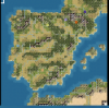
Aerial view of the southern part of the clean map (resources highlighted):

Aerial view of the northern part of the clean map (resources highlighted):

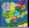
View from orbit onto most of the Iberian peninsula of the map with preplaced barbarian cities - in identical positions as in the Taifa scenario:

The last two screenshots are the overview maps of the scenario and the clean map, which I both have attached to this posting.
Happy Civving!
Spain. The year is 1031. The Caliphate of Cordoba has been formally dissolved. The once glorious empire is split into numerous small kingdoms, the so-called Taifas, who are fighting amongst themselves as much as against the slowly rising Christian kingdoms in the north and in the east, in the shadows of the Pyrenees.
Taking on the leadership of one of the Taifas, can you create a greater destiny and reunite the lands of the Moors under the flags of your house? Or can you, leading one of the Christian kingdoms, seize the day and carry on the Reconquista, the reconquest of the lost lands, taking the Muslim Taifas one by one? In, let's say, less than four and half centuries?
You will play on a 40x40 tiles map wich loads and plays very fast despite the relatively high number of civilizations (18). Standard rules are in effect. Gamespeed is Marathon to stay longer in medieval times and to have cheaper troops as opposed to buildings.
Playable civilizations are the five Taifas Cordoba, Sevilla, Granada, Valencia and Majorca, and the five kingdoms of Leon, Castille, Navarra, Portugal and Aragon. On the map present but not playable are France, the Almoravids, Badajoz, Toledo, Zaragoza, Silves, Cartagena and Almeria. The last six are minor civilizations and always at war with everybody.
What's this?
Spoiler :
Attached to this post is a zip file containing a number of maps. This includes next to the main scenario the base map and some "free play" settings on said map. A detailed list:
- SpainTaifas1031AD. This is the main scenario.
- SpainClearWithNotes. This is the base map with notes. This map may be used for a scenario and is not intended to be played as is.Spoiler :I have placed labels on the map to denote where important cities might be placed (which is sometimes a little off from a more realistic location as is the case with Badajoz and Zaragoza to enable a better gameplay) and below it a number which designates the food surplus of this location. That is the number of tiles which need not be irrigated or windmilled, not regarding the intrinsic food surplus of 2 that every city has.
- SpainFactions. This is the base map with notes and factions. This map may be used for a scenario and is not intended to be played as is.Spoiler :It is SpainClearWithNotes extended by the definition of eighteen civilizations as used in the Taifa scenario. Defined are names, start positions, but not technologies and also no city names.
- SpainFreePlayAD700. "Free Play Mode". All 10 civilizations start with a few units and no cities on a clear map. The starting date of 700 AD is rather arbitrary.
- SpainFactionsAD700-02. "Free Play Mode". The same as SpainFreePlayAD700, except the number of civilizations included is raised from 10 to 14, mainly to release a bit of pressure from Cordoba.
- SpainFactionsAD700Barbs. "Free Play Mode". The same as SpainFreePlayAD700, except here lots of lightly defended barbarian cities are preplaced in (more or less) historical positions.
Installation
Spoiler :
Unzip the attached file in a directory of your choice. Move those files you want in either your WorldBuilder directory (most likely C:\Documents and Settings\My Computer\My Documents\My Games\Beyond the Sword\Saves\WorldBuilder) or, probably better, in your public maps directory (most likely C:\Documents and Settings\My Computer\My Documents\My Games\Beyond the Sword\PublicMaps). Delete the downloaded file and any extracted file unused. Note that Civ4 may not find the new files immediately if you do this while Civ is running.
A word on the map
Spoiler :
The map represents a portion of earth almost exactly from 10° west to 5° east and 35° north to 45° north as depicted in Akademische Verlagsanstalt, "Peters Atlas", 1989.
The transformation to a 40x40 tiles grid is, of course, not without loss of information and imprecision. I have tried to be mostly true with coast lines and river flow. The general location of mountain ranges should be vaguely correct also although I have already taken artistic license here, i.e. to create space around the city of Jaca in the pyrenees. The distribution of grassland vs plains, however, (and other land terrain was not used for this map) is purely functional. In general I placed plains on lowlands and grasslands on hills. This way, all tiles have the basic output, especially with regards to food, making balancing considerably easier. Balancing was done by assigning every city a number defining its maximum possible food surplus after working all tiles that produce more than two food (after irrigating). This food surplus can be translated into production (mines or hills with forest) or commerce (cottages). The distribution of food bonuses was purely functional, that of strategic resources mostly as well, although I placed copper near Toledo because my historical atlas, Bayrischer Schulbuchverlag, "Grosser Historischer Weltatlas", 1970, Vol. II, p. 87, indicated such a thing. Distribution of luxury resources was mixed: I placed gems next to almost each capital, the rest was a rough translation of what said atlas indicated, or how I (mis)understood or (mis)interpreted it.
Short historical overview
Spoiler :
The Visigoth empire on the Iberian peninsula was invaded 711 by Berbers and successfully conquered in the following years for the Ummayad Caliphate, except for a small part in the north, the later kingdom of Asturia, precursor of Leon, Castille and Portugal. After the overthrow of the Ummayads back home in Damascus, an Ummayad survivor flew to the Iberian peninsula, grabbed power and founded the Emirate of Cordoba 756 which lasted until 929, with the power of the Emirs ever dwindling. 929 Abd-al-Rahman III came to power, elevated himself to Caliph and subjugated all Islamic areas again. He reigned for 50 years. After his death a power struggle between the heirs of his heir and the heirs of his Chancellor broke out. The power struggle bound all resources and ultimately lead to the demise of the Caliphate, which was officially dissolved in 1031. Lots of independent kingdoms, called Taifas, now fought against each other. After the fall of Toledo into Christian hands in 1085 the Berbers under Almoravid rule were called for help, who instead conquered the Taifas. The Almoravid rule detoriated and again, Taifas emerged. After the fall of Lisbon into Christian hands 1147 the Berbers this time under Almohad rule were called for help who, well, who instead conquered the Taifas. The Christian kingdoms completed their Reconquista with the conquest of Granada in 1492, the same year the new world was (re-)discovered.
Additional notes
Spoiler :
I have tested the maps to a certain amount, but issues may still remain, mainly concerning historical accuracy. For instance I do have the feeling that France might be to strong, since it ended up in one of my games doing most of the Reconquista. The Almoravids on the other hand might be either too weak or too much hampered by the fact that they are on another continent. They never came by for a "visit" in any of my (few) games. I am loosely thinking about closing the strait of Gibraltar, so that the Almoravids can invade Hispania much more easily.
Screenshots
The screenshots are taken from the start of the Taifa scenario if not noted otherwise.
Galicia (Nortwestern Spain):
Spoiler :

Castille start position (Northern Spain):
Spoiler :

Crown of Aragon start position (Pyrenees, Eastern Spain):
Spoiler :

Taifa of Sevilla (Southwestern Spain):
Spoiler :

Taifa of Granada (Southern Spain):
Spoiler :

Taifa of Valencia (Southeastern Spain):
Spoiler :

Aerial view of the southern part of the clean map (resources highlighted):
Spoiler :

Aerial view of the northern part of the clean map (resources highlighted):
Spoiler :

View from orbit onto most of the Iberian peninsula of the map with preplaced barbarian cities - in identical positions as in the Taifa scenario:
Spoiler :

The last two screenshots are the overview maps of the scenario and the clean map, which I both have attached to this posting.
Happy Civving!
")