Rhye
's and Fall creator
(Preview #1 here)
(Preview #2 here)
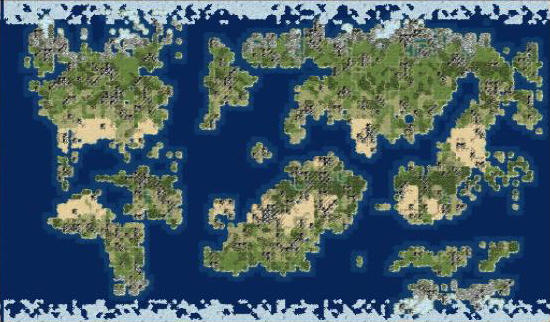
Let's see how the RFC RAND world looks like.
The biggest priority is to ensure that the world contains all the civs at the same time.
Randomly generated maps usually fail, because their % of land is very low (the huge size can contain up to 11 civs), unless the size is exaggerately big.
This is the typical result of the Terra mapscript:
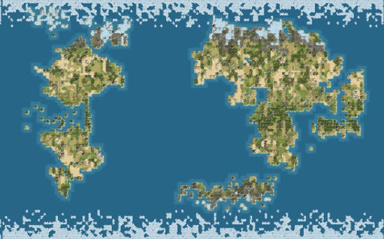
The ocean is 20 or more tiles wide.
RFC uses a different script, based on Terra, but that ensures that water coverage is limited to 60-65%.
A parameter called "Earth likelihood" (is it grammatically correct?) sets how much the world generated is similar to the Earth or more random.
Eventually, an algorithm checks that the two biggest groups of continents are separated by at least 5-6 water tiles.
This screenshot not only shows the landmasses. A few comments can be added:
- Oceans are enough big to separate the two "worlds"
- Terrains are disposed as shown in preview #1: big areas
- The equator isn't actually centered, but in this case, it's more southwards. Because of this fact, the (in this case) northern hemisphere is more comfortable (except for tundra and marshes), while the southern one offers a lot of jungle and desert
- This map is actually smaller than the one in the first screenshot!
(Preview #2 here)
Let's see how the RFC RAND world looks like.
The biggest priority is to ensure that the world contains all the civs at the same time.
Randomly generated maps usually fail, because their % of land is very low (the huge size can contain up to 11 civs), unless the size is exaggerately big.
This is the typical result of the Terra mapscript:
The ocean is 20 or more tiles wide.
RFC uses a different script, based on Terra, but that ensures that water coverage is limited to 60-65%.
A parameter called "Earth likelihood" (is it grammatically correct?) sets how much the world generated is similar to the Earth or more random.
Eventually, an algorithm checks that the two biggest groups of continents are separated by at least 5-6 water tiles.
This screenshot not only shows the landmasses. A few comments can be added:
- Oceans are enough big to separate the two "worlds"
- Terrains are disposed as shown in preview #1: big areas
- The equator isn't actually centered, but in this case, it's more southwards. Because of this fact, the (in this case) northern hemisphere is more comfortable (except for tundra and marshes), while the southern one offers a lot of jungle and desert
- This map is actually smaller than the one in the first screenshot!

")
