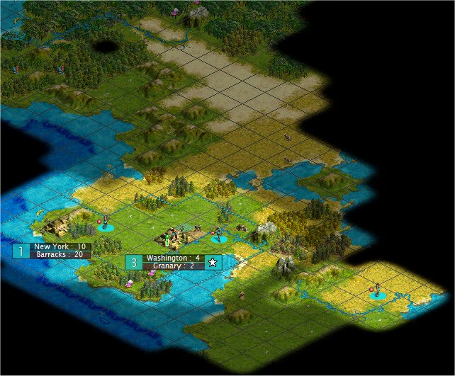
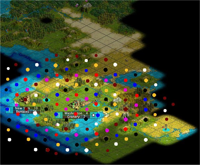
Ring City Placement

My method of counting just imagine you have a knight piece in chess and it turns direction each time it hits one of the eight axis. And in cases it did not hit right on the axis, it is a mirror image around the axis.
 
Yikes! I just spent 2 hours trying to figure out what distance to put my second ring after popping an advanced tribe in a solo game. Would anyone care to take a look at a picture and make some recommendations? (there are two slight mistakes in the second maroon distance (7.5) but just ignore the two tiles that are wrongly colored)

Speaker_-_Map.jpg


Speaker_-_CRP.jpg
 
RCP gives you very little advantage in this start. No matter what radius you choose, over half your second ring locations will be in the ocean.

You can still reduce corruption by placing a few cities at equal distance, but you won't see any powerful low-corruption rings.
 
Sorry, I was a too general in my last post. I meant to address the 2nd ring question.

That first ring with New York does look good. You could fit 5 cities in with no problems, and they all get a nice early production boost. The 6th city (4 tiles southeast) would have to give up freshwater to fit in.

In the second ring you could fit in 7 cities at radius 7.5, but a couple of those are in bad locations (on top of shielded grassland with no freshwater; in the middle of 1-food tiles). RCP certainly wouldn't hurt, but I can't see a huge benefit either.
 
I've been taking lots of screenshots and doing some editing for my own "urban planning." Thought this might help:

Speaker_-_Map-rings.jpg


Without regard to recourses, here's how the numbers add up:

(+x indicates predicted water squares, not guarantee of accuracy, of course ;) )

dist......city sites
4.........7
4.5......5
5.........4
5.5......5
6.........6
6.5......7
7.........6+2
7.5......8+1
8.........7+3
8.5......9+2
9.......10+3
9.5.....11+2
 
I can't really comment on the situation above, not having reviewed it carefully, but I thought that I'd offer some quick analysis numbers for all land squares (ie pangea) in the target area:

As noted in the initial charts, but not counting adjacent squares:
Distance 1.0 1.5 2.0 2.5 3.0 3.5 4.0 4.5 5.0 5.5 ... 7.0
# Sites 5 5 5 9 9 9 13 13 13 17 21

More analysis shows that you can maximize the number of squares used at 5.5 (178 squares) counting shared squares as 0.5, and unused as 0. The best % utilization is at 5.0 in a "crossed H" pattern, with 7 cities, 10 shared & 2 unused for 95.2%.

Ciao!
 
I've spent ages trying to work out a decent RCP placement during this month's GOTM (printed out the map so far and put lots of coloured numbers on the tiles!), and am thinking about adding an app into my CIVReplay stuff to do this. What I'm thinking is you open up a .SAV, it shows you the map (as seen in CRpViewer/CRpSettleLoc but with FOW), you select a city from the list of those available, it overlays the map with pretty colours and useful RCP distances. Would anyone be interested?
 
Originally posted by Dianthus
... and am thinking about adding an app into my CIVReplay stuff to do this ... Would anyone be interested?
Yes!! I think that would be a wonderful present! I mostly gave up on RCP this month (I managed distances of just a few early towns) because it was so tedious (to me :) ) working out all the options. Decided to just barrel ahead without. I'd love a utility like that and would use it.

One request from me: allow selection of any tile as the center, not just a selection of any city. I hit my limit of frustration thinking about RCP this month while trying to pick the best location for my new Palace town - I was choosing among possible center locations before settling it and eventually gave it up, just picking the place I liked most without considering RCP.
 
Me too. I was thinking about a photoshop overlay but using an interactive screen that comes from an existing sav would be awesome!

I've downloaded your CivReplay but never fired it up. This would be a great excuse for me to get it going.

Keep up the good work.:goodjob:
 
Originally posted by SirPleb
I'd love a utility like that and would use it.
I'll probably get this into the next release of the CIVReplay stuff at the end of this month, assuming this months GOTM doesn't steal all my "free" time :).

Originally posted by SirPleb
One request from me: allow selection of any tile as the center, not just a selection of any city.
I'm not sure I'll get this into the 1st release. I don't currently have a way of associating a mouse click with a particular tile on the map. That's why I mentioned the city list as it's easier! I'll give it a go though as I want to be a able to do context sensitive stuff in CRpViewer/CRpSettleLoc anyway.
 
Originally posted by ControlFreak
I've downloaded your CivReplay but never fired it up. This would be a great excuse for me to get it going.
ControlFreak, make sure you look at the latest version (I updated it about a week ago). It looks a lot better with the forest/jungle/hills/mountains/rivers/resources!
 
I realized I never even installed the first one. Just downloaded the zip. I trashed it and got version 2.1. It looks great! (other than the part about everyone elses lines being higher than mine:lol: )

Question, will this work for 1.27 patched games? I'm guessing you'll have to release another version. (Sorry for threadjacking.) I think RCP overlay will be a fabulous feature!
 
Originally posted by Qitai
RCP
Notice that my 3 distance town and 3.5 distance town has the same corruption level. Break away from game to do some testing on corruption. Test result shows that I always get same corruption for cities at n and n+0.5 (e.g. 10 and 10.5 gets same corruption). [/B]

GOTM spoiler link deleted

Trying to gather the info in one place. Thanks Qitai. :goodjob:

Edit: Sorry Chieftess :blush: And thanks
 
Has it been confirmed that for "City Rank" in the corruption calculations is only based on the number of cities closer to the capital than the city in question? Or is there a secondary criteria for determining rank such as the age of the city?
 
Originally posted by sysyphus
Has it been confirmed that for "City Rank" in the corruption calculations is only based on the number of cities closer to the capital than the city in question? Or is there a secondary criteria for determining rank such as the age of the city?

When I first started testing I was labeling cities by order of creation and distance from palace. Sometimes outer cities were placed before inner cities and the age of a city never made any difference. All cities in any particular ring all had the same corruption.
 
As far as anyone knows, and until we get evidence suggesting otherwise, rank depends only on distance. :)
 
Back
Top Bottom