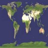
Scenario maker's fantasy come true!

Here, I located the original source:

http://www.johnstonsarchive.net/spaceart/cylmaps.html

-- (Also has cool map of Mars with water) --

which is in turn derived from Cornell University's Interactive Mapping and Data Analysis online machine.

The map shows sea levels +80 meters (probably impossible as a result of human efforts, due to the amount of ice stored in deep Antartic crevasses; equals ~10,000 years hypothesized climate change.

... And here's a better jpg for mrtn :) :
 
Ozymandias, this is much better; it's gorgeous.
 
Very cool!...Especially a forested Antarctica!:D Your mapping program seems to be the same one I linked to in Post #1...Though it has given rise to the fact that +80 meters is the max...I'll change that...:)
 
P.S. I just tried that pic in BMP to BIC and it didn't work...I sense a long day of color-editing ahead....:undecide:
 
Originally posted by Amenhotep7
P.S. I just tried that pic in BMP to BIC and it didn't work...I sense a long day of color-editing ahead....:undecide:

Probably a silly question, but I uploaded it as a .jpg -- you did convert it to a .bmp first, yes?

Best,

Oz
 
I converted itfrom Jpeg to Bmp...:undecide:
 
Well, I'm working on this map. Ozymandias says that it should convert right away. When I go to convert it, it doesn't work. The BMPtoBIC output is a whole lotta ocean and nothin' but...Help?:(
 

Attachments

  • earthicefree3.jpg
    earthicefree3.jpg
    18.2 KB · Views: 83
Originally posted by Amenhotep7
Well, I'm working on this map. Ozymandias says that it should convert right away. When I go to convert it, it doesn't work. The BMPtoBIC output is a whole lotta ocean and nothin' but...Help?:(

:( Yeah, it's wierd, I just tried it on a different .bmp and got basically Greenland and Antarctica and literally nothing else! -- Yet El Mency evidently used this utility to generate some extraordinary maps (one was so good that Teturkan thought his had been "borrowed).

Anyway, here's the CFC thread on the topic:

http://forums.civfanatics.com/showthread.php?postid=509766#post509766

(really begins at the fourth post)

-- Hopefully you'll find some help in there.

Apologies,

Oz
 
Uhh, All I need now is how to convert palletes.:undecide: I don't think Photoimpression4 or mspaint'll do...So exactly where is a demo of Photoshop?:confused::D
 
Hmm..Well, with all the ice in the world, it's not possible to flood more than 80 meters, but sure!:) Of course, I'll need to finish my Ice Age map, World as the Greeks saw map, Caribbean map, and I may put my Atlantis area map on hold for more flooded world map...I'll be a very busy Pharaoh!:lol:
 
Anybody who can tell me how to edit pallates???
 
Can somebody at least point me to a tutorial???:confused: Either that, or I could just make an edit of Marla's map, but I don't wanna do that, since that's kinda cheating.:(
 
Originally posted by Amenhotep7
Can somebody at least point me to a tutorial???:confused: Either that, or I could just make an edit of Marla's map, but I don't wanna do that, since that's kinda cheating.:(

Why? I'm editing Teturkhan's map and plan to give him full credit.

-Oz

PS Of course T's map was released with the product; you might want to ask Marla's permission first -- certainly a polite gesture :) -- but upgrades have been ongoing to her map without her ...

-Oz
 
I could hand-edit the colors on the .bmp.:undecide: I'll ask Marla, and hopefully she'll gimme her persmission.:)
 
Back
Top Bottom