You are using an out of date browser. It may not display this or other websites correctly.
You should upgrade or use an alternative browser.
You should upgrade or use an alternative browser.
TETurkhan Test of Time (Map & Mod)
- Thread starter TETurkhan
- Start date
wurkwurk
Chieftain
Tet:
Is it possible at all to make LM hills desert hills? The Sahara looks pretty odd with green hills popping out of an empty desert.
Is it possible at all to make LM hills desert hills? The Sahara looks pretty odd with green hills popping out of an empty desert.
warmwaffles
Programmer
Never have heard of that idea that is great. I better put that in my personal mod.
I havent seen desert hills but ive seen desert=boneland plains=wasteland forest=acient forest they each look different, you shuold be able to do the same with hills, change the appearance of Landmark hills or deserts, even the amount of food and sheilds it provides.
I saw it in the WH mod (warhammer mod). I got it off Civ fanatics heres the link take a look at it see what i mean.
http://forums.civfanatics.com/showthread.php?threadid=66060
I saw it in the WH mod (warhammer mod). I got it off Civ fanatics heres the link take a look at it see what i mean.
http://forums.civfanatics.com/showthread.php?threadid=66060
wurkwurk said:Tet:
Is it possible at all to make LM hills desert hills? The Sahara looks pretty odd with green hills popping out of an empty desert.
He has already done that. You can see a picture in the previous page.

")
Finally done shaping South America. Now to do the Islands in the Pacific...
This is now what I call my 'retirement map' - no more after this one - it is just way too much work!
Originally I was using El's huge map for test of time 2.0, and thinking about it now, maybe I should have cause it would have saved me a lot of time... anyhow what is done (or almost done") ) is done.
) is done.
I have dedicated my entire weekend to this... I want to finish by the end of tomorrow (Sunday).
This is now what I call my 'retirement map' - no more after this one - it is just way too much work!
Originally I was using El's huge map for test of time 2.0, and thinking about it now, maybe I should have cause it would have saved me a lot of time... anyhow what is done (or almost done
) is done. I have dedicated my entire weekend to this... I want to finish by the end of tomorrow (Sunday).
some terrain just seems out of place color wise when placed besides others... I have already given up some level of accuracy as far as terrain type goes in order to get the right shape along coasts... if I also try to get the colors to flow more naturally then the terrain accuracy will even less...
I am happy with the current balance. Just be patient and wait until the map is done.
Here is a preview of the Great Lakes (note - sea units can now access them via the Atlantic).
I am happy with the current balance. Just be patient and wait until the map is done.
Here is a preview of the Great Lakes (note - sea units can now access them via the Atlantic).
Attachments
tjedge1
Writer of writerly things
That is breathtaking TE. Amazing work. I can't wait to play this mod.
azazel93
Aspiring World Dictator
Damn those maps look great! i had recently uninstalled civ from my comp because i didnt think the new tet would ever get done, lol, guess i was wrong, lol!
ill be checking back everyday until its done, by the way, when is this thought to be finished?
ill be checking back everyday until its done, by the way, when is this thought to be finished?
Lord Apolon
Warlord
- Joined
- Apr 28, 2002
- Messages
- 131
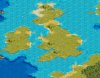
Wow. Can't wait. A bit surprised by the lack of forests in England... but he said there aren't rivers yet either, so we'll see.
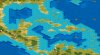
I think the pollution is some kind of gridding system. Look at the Cuba map; all the polluted squares are aligned horizontically and vertically with other polluted squares...
Can't wait. Just re-installed Civ on my new laptop, too, so I should be able to run these maps without insane slowdown.. I hope.
Let me clarify a few things.
1. Only the shaping of the coasts has been done so far. The forests, rivers, mountains etc still has to be done along with Civ start points and city locations (since all places that you can settle in this map are predetermined).
2. Pollution spots serves as markers where longitude and latitude lines cross on a globe. Sometimes I even break each square (on globe) into further smaller pieces. This helps me to get the spacing right in certain spots. It is the same system that I used in creating the 256x256 world map.
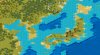
3. The preview images are not separate maps but part of one world map. It is absolutely huge and thus the time delays. The level of detail that can be reached on such a huge map is amazing though incredibly time consuming. That is why I call this map my retirement one I have no desire to do another. 3 maps is enough - any more and I will lose it!
1. Only the shaping of the coasts has been done so far. The forests, rivers, mountains etc still has to be done along with Civ start points and city locations (since all places that you can settle in this map are predetermined).
2. Pollution spots serves as markers where longitude and latitude lines cross on a globe. Sometimes I even break each square (on globe) into further smaller pieces. This helps me to get the spacing right in certain spots. It is the same system that I used in creating the 256x256 world map.
3. The preview images are not separate maps but part of one world map. It is absolutely huge and thus the time delays. The level of detail that can be reached on such a huge map is amazing though incredibly time consuming. That is why I call this map my retirement one I have no desire to do another. 3 maps is enough - any more and I will lose it!
Similar threads
- Replies
- 2
- Views
- 333
- Replies
- 4
- Views
- 277
- Replies
- 1
- Views
- 335
- Replies
- 2
- Views
- 276