Arne's Worldmap 180x180

Arne

King
Joined
Apr 24, 2001
Messages
890
Location
Rostock (GER)
The Map is based on the [Huge and bad] Firaxis Map (180x180) and it is basicly for CFC's who have problems with Marlas Map because Marlas is too large. It was my first map, but there are lots of changes compared to the Original Firaxis Map. My main focus was on a) a slighly larger Europe, b) making sure interistig naval movement.

The readme is german only, sorry. (In new Version for C3C no readme is included).

-----------------------------------------------------------------------------------

NEW: C3C-Version: minimap-Preview C3C-Europe-Preview

The File [edit: C3Cversion 2.1] is available (only) here.

-----------------------------------------------------------------------------------
Version 1.2: There are some changes like:

starting locations moved
+ Americans moved southern a few squares,
+ Zulus moved eastwards (near the Civ2-starting-location)
+ Aztekes moved to Mexico City (instad of starting at Yukatan)
+ Persians moved soth-east. It is still not the korrekt starting location, because Persepolis is situated only 2 squares away from Babylon, so I put it between Babylon and Dehli.

terrains are changed
+ some smaller changes in Asia, Europe, South America and Australia
+ it IS changed the eastcoast of US/Canada
+ (but NOT added any new rivers)
+ some coastlines are changed again (Mexico and some smaller others)

some ressource placements are changed
(more whales, uranium, fish...)

-----------------------------------------------------------------------------------
Version 1.3 is now available.

There are only minor changes like:
- added some Rivers (Mackanzie, Youkon...)
- added the Shetlands (Tundra+Oil) to represent Northsea Oil
- added some Bonus graslands in England and Japan
- moved SP for Japan one square - river now goes along SP
- added goody hut in England
- added Gems to Namibia
- some smaller changes to terrain, ressources and coastlines

ATTENTION: Sorry, versions 1.2 and 1.3 are no longer available. But there is a new C3C-version. It's still a pure map, no rules changed. Europe is again larger and there are a lot smaller changes all over the world.

Version C3C 2.1

- greenland and other cold regions are much harder to settle
- changed a lot of terrains
- Sandinavia and other parts of Europe are larger and nicer again
- iberian Peninsula is a few terrain dots larger
- NW-Africa Coastline changed
- the Black Sea is now little larger than in C3C version 2.0
- russian SP moved
- added some snowcapped mountains n N- and S-America
- added some ressources al over the world

* Still need some hints for spanish SP and also for Hethitian and ottoman SP
* It's still a pure map, no rules are changed
 
Good Work!:goodjob:

First playable worldmap with large european continent! (weiter so!!) :love:
 
Nice map. Persepholos (sp) started too far north, though. (about 13 tiles or so). Haven't seen the NA civs yet...
Also, the Zulus are starting on the opposite side of Africa. They should be at their Civ2 position. Mexico also looks a little warped (from the screenshot perspective).

Tenochtilan is in Guatamalia on this map, not where it's supposed to be, in Mexico City.
 
Originally posted by Chieftess
Nice map. Persepholos (sp) started too far north, though. (about 13 tiles or so). Haven't seen the NA civs yet...
Also, the Zulus are starting on the opposite side of Africa. They should be at their Civ2 position. Mexico also looks a little warped (from the screenshot perspective).
Persepolis: Yes, I know. It's more the position of Samarkant, then Persepolis ;)
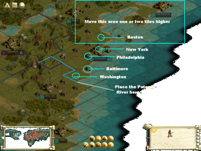
. But I tough, there is much space for all Civs, and why they should start all near eachother (Persepolies near Babylon). Do you all think, I should fix this?

Zulus: Well, it seems, I should fix it.

Mexico: hmmh... is it? Well I check this out. (The Aztecs are starting at Yukatan [like Maya would start]. My intension was, they should settle more in the southern direction instad also northern, so I placed them there.) May be, Mexico is to small, but the Coastline should be mostly correct. I still miss the zoom or minimap in the editor...
 
One more. Washington. It's around where New York is right now. It should be a few squares lower (just to the left of that fish - where Baltimore is - I'm hoping you *do* know where Baltimore is... :) ). Or, you could put it one tile to the south-west, which is Washinton DC. Plus, there's no Patomic river there... (make it go diagonal for a a square or two - right below that fish.

(picture with descriptions in the next post).
Hey, I like my "back yard" to be accurate. :D
 
That one area where I said one or two tiles north. I would prefer 2. (It takes me 3 hours to get to New York - 1.5 to Philly - and it would take me 6 hours to get to Boston, so Boston is a little too close. I know New York (the state) has Long Island, which sticks out, but Boston's cove is more prominent.) Plus, you could move the entire Eastern Canadian region up along with the North Eastern US. The "foot" of the Hudson Bay is a little short. (it could be fixed if Eastern Canada were moved north and west few squares.) Besides Boston, Newfoundland (that area where the two is) could be moved up an additional tile or two from Boston. It looks a little close.

Lake Ontario (the eastern most lake) should be (both tiles) pushed one tile north-west. Also, Lake Superior (the western most lake) should have be enlarged (take a look at an actual map to see what the lakes look like).

BTW, you can tell I was using a "trainer" to test some stuff out. (mainly modern armor vs spearmen, and why some spearmen seem to defeat my modern units. :))
 

Attachments

  • midat.gif
    midat.gif
    420.8 KB · Views: 7,067
Originally posted by Chieftess
That one area where I said one or two tiles north. I would prefer 2. (It takes me 3 hours to get to New York - 1.5 to Philly - and it would take me 6 hours to get to Boston, so Boston is a little too close. I know New York (the state) has Long Island, which sticks out, but Boston's cove is more prominent.) Plus, you could move the entire Eastern Canadian region up along with the North Eastern US. The "foot" of the Hudson Bay is a little short. (it could be fixed if Eastern Canada were moved north and west few squares.) Besides Boston, Newfoundland (that area where the two is) could be moved up an additional tile or two from Boston. It looks a little close.
Thanks for comment. :) Hmmm, I don't know if I would change this all. There are some reasons against this: North and Southamerica are settled by only 3 Civs. If I add more Space on the NA East Coast, they will become even more stronger then they are allready now. I think, I will have a look at it, and try to correct some things (Washington for example) but I think, I will not add more good space for cities in NA.

Originally posted by Chieftess
Lake Ontario (the eastern most lake) should be (both tiles) pushed one tile north-west. Also, Lake Superior (the western most lake) should have be enlarged (take a look at an actual map to see what the lakes look like).
Oh well, it's hard to make this right, because the space for all the lakes is small and if I used an other terrain, the coastline will be different... Even on Marlas much larger(!) Map the lakes where not showed really correct. And if I add one suare to Lake Superior then it seems to large to me. However, I'll try it out.
 
I'm new to Civilisation III, infact I haven't got it yet! Buying it tomorrow or the next day, but looking through this site I'd like to play on a real earth map and there seems to be 2 to choose from, this one and Marlas Map (the bigger one)...

So from users who've tired one or both, which is the best? Are they both good, is one better than that other...?

I have an AMD-1000 (overclockable upto 1300'ish) and Geforce-2 MX video. I gave the specs because I not sure if thats sufficient to run Marlas Map or not? It should be tho right?

Anyway which is the best map.
Thanks kindly
 
Now is the second version (v.1.2) available at the Civ Universum. There are some changes like:

- starting locations moved
+ Americans moved southern a few squares,
+ Zulus moved eastwards (near the Civ2-starting-location)
+ Aztekes moved to Mexico City (instad of starting at Yukatan)
+ Persians moved soth-east. It is still not the korrekt starting location, because Persepolis is situated only 2 squares away from Babylon, so I put it between Babylon and Dehli.

- terrains are changed
+ some smaller changes in Asia, Europe, South America and Australia
+ it IS changed the eastcoast of US/Canada
+ (but NOT added any new rivers)
+ some coastlines are changed again (Mexico and some smaller others)

- some ressource placements are changed (more whales, uranium, fish...)
 
Really great map. The marla-maps are way too slow for my computer. Huge maps are slow too, but not 25 minutes per turn slow. Anyways, a few suggestions:

-Merge Japanese Islands - Having all of the Japanese islands together will help Japan quite a bit, they are quite weak as it is (on island)

-Add Scottish oil - Add an arctic or desert tile to the tip of Scotland and put oil there to represent north sea oil - helps Island stuck England

-Add (many) goody huts to Britain, Ireland and Japan - The Island civs are too weak otherwise.

I'll give more suggestions the more I play it.
 
I've noticed the problem with island civs. Thats why I added the Thames River and the Tone-gawa River even if they are normaly to small for being on this map. And both islands are made a little larger (f.e. compared to remaining Europe). My first solution was, to add galleys instad of scouts to these both civs (or give the technology to build some). But since maps with changed rules edited with the english version can't be played with german version (remember our site is a german one) all changed rules are moved away.

@Merging Islands together: One of the most important things (to me) during making this map, was making the islands really being islands. So merging islands togehter seems not to be a good solution.

@goody huts: Adding goody huts is of cource a good idea. I don't know, why I don't make it til now... there seems to be space for 2 huts on Britain an one in Ireland. And also two on Honshu and one on Hokkaido.

@North Sea oil: Finaly adding North Sea Oil is a good idea too. I think, I will add a one tundra square Shetland island and put oil on it. So I hope, these Shetlands can be settled by any civ, but England sould be the first.

Thank you for comment and suggestions. :)
 
Just a small suggestion on the island civs, edit them to start with map making. While they start off technologically advanced, they can get off those islands much easier. I have only tested it twice so far, but it did make a difference.
 
I still work on this. Remember: I can't change any rules as long as the german Version can't use it. So I added in version 1.3 (still in process) some sqares to Britain (-> should give the England player space for one more city), moved the Starting location for Japan one square south east (-> Now the capital is situated on the Tone-gawa River and it's possible to growing fast and without using a aqueduct).

Some plans for v.1.3
- add Yukon River
- move Island one square
- (may be) add more/check ressources
- ...?

British Islands in version1.3:
 
Originally posted by bhamtiger
How do I fix the start positions with your 180x180 world map?

Thanks,

bhamtiger
Fixing? Hmmh, in Version 1.2 they are fixed. I wrote a small tutorial "How to play with and how to create starting positions by using Gramphos Civ3MultiTool v0.83" at our site. [Note: Please use the newest versions of C3MT or CPT for newer Civ3 versions than 1.17f. The tutorial was written for 1.17f and C3MT v0.83.] The tutorial is in German only, but there are some picts to show what I mean. It's simple, it looks more complicatet then it is.

The translated tutorial:
First you need a tool for doing this. (Gramphos C3MT or CPT). Then you need a text editor (notepad) and of cource Civ3edit.

1. CREATE starting positions (for my map this step is allready done)

1.1. start Civ3CopyTool (part of C3MT)
1.2. "Select BIC-File" - open the *.bic in CopyTool
1.3. "Generate CPF" - CopyTool is creating a *.CPF-file with starting positons generated in Civ3Edit
1.4. start notepad - open this in 1.3. created *.CPF-file and the "example.cpf" from the C3MT directory
1.5. open *.bic in Civ3Edit
1.6. copy NAME=**** and ID=**** for the correct civs from "example.cpf" into your *.CPF (compare with map in Civ3Edit)
1.7. save the CPF

2. How to play with starting positions? (Only this step is necessarily for playing my map with correct starting locations.)

2.1. start Civ3, open "ArnesWelt1_2.bic", save Game immediately - before doing anyting else (-> somthing like "4.000 BC ***your nation***.SAV")
2.2. start C3MT SaveGameModifer, load "4.000 BC ***your nation***.SAV"
2.3. Load Starting Positions in SaveGameEditor (*.CPF file)
2.4. save new (**Gamename***.SAV) in SaveGameEditor
2.5. load saved file (**Gamename***.SAV) in Civ3
2.6. play

I hope, this cold help a little? I don't know, if the new patch 1.21f this friday will make somthing easyer then this is. But, like I sad before, this is easyer then it seems.
 
GoodJob!!:goodjob:
 
Thank you Cherokee158, thank you Strider. :)

I stoped working on the next version of this map for long time. May be I could finish it now. I think, I will remove the added terrains to Britain again. Simply becouse Britain is great, but it isn't that great like is will be if the squares where added. ;) Compared to the rest of Europe, of cource. I have to test now my solution. Hope it works with most Civ3-versions.
 
Top Bottom