- Home
- Forums
- CIVILIZATION IV
- Civ4 - Creation & Customization
- Civ4 - Project & Mod Development
- Civ4 - Dune Wars
You are using an out of date browser. It may not display this or other websites correctly.
You should upgrade or use an alternative browser.
You should upgrade or use an alternative browser.
Arrakis.py map script discussion
- Thread starter cephalo
- Start date
Deliverator
Graphical Hackificator
If I remember correct, the polar regions had a more moist atmosphere compared to the rest of the planet, wich made it easier to extract water from. And the terrain was more rocky/hilly compared to the rest of the planet.
Changing food to water sounds best to represent the scarceniss from water. Windfalls should further only be buildeble on food and hill terrain.
I have opened a separate thread to discuss the pros and cons of changing food to water.
Deliverator
Graphical Hackificator
For the next phase maybe I'll arrange the most fertile areas toward the pole. The trick will be to make it look like something naturally occuring. Concentric circles would probably look dumb. There has to be a second factor along with distance from the pole that would effect habitability. Any ideas?
"As indicated by large salt flats, Arrakis once had lakes and oceans."
I'm wondering if you can simulate rivers carving out valleys and lakes in the landscape. The rivers could radiate in a random way out from the centre. The river valleys could be desert waste/deep desert and the ridges the fertile rock areas.
cephalo
Deity
"As indicated by large salt flats, Arrakis once had lakes and oceans."
I'm wondering if you can simulate rivers carving out valleys and lakes in the landscape. The rivers could radiate in a random way out from the centre. The river valleys could be desert waste/deep desert and the ridges the fertile rock areas.
I kinda wish that we could de-couple 'sea' tiles from the PLOT_OCEAN plot type in the SDK. Salt flats and wet sand would look much better as PLOT_OCEAN's. I'd like the water vs. land travel to go by terrain type. That way I could also make the dunes be considered ocean.
EDIT: Is the source code included in the 'dune wars' folder? I'm at work so I can't check. I may be able to figure out if this can be done.
Deliverator
Graphical Hackificator
I believe Keldath has included it as a auto-unzip file called sdk.exe.
cephalo
Deity
I'll try to get updated version next week. I still want a chance to see what my options are for what I'm going to put on it.
Deliverator
Graphical Hackificator
I still want a chance to see what my options are for what I'm going to put on it.
This is an intriguing sentence. What do you mean exactly?
cephalo
Deity
This is an intriguing sentence. What do you mean exactly?
I'm messing around with the dll so that water is tied to terrain type rather than plot type. I'm hoping that we can have land types lying low like ocean but walkable for salt flats, and water types for hills so the the dunes can be considered water by the AI.
So far it's half way working... I'm getting some weird results that I need to understand further to get things under control.
One thing that I was not expecting, is that hills and peaks can be placed directly on the ocean floor. I had thought that there were basically 4 different altitudes, but it doesn't work that way. If I use WB and place a peak on the deep desert, I get the peak shape with the deep desert texture! My understanding of the system has become unhinged lol.
EDIT: One thing that will need to be done is to get rid of the specularity of the water surface. If I make 'arid' in the ocean level, it blends with the water surface texture and changes the color in an unappealing way.
Deliverator
Graphical Hackificator
If you mean the sparkly sand sea, I'm not a big fan of it anyway...
cephalo
Deity
Well, I don't think it's possible to remove the land water distinction. I was able to set isWater() according to terrain type, but the problem is that the graphics engine already uses terrain type to decide on the base altitude of land or water, and it happens outside of the dll.
I can set land terrain below the water line with WB, but when you save and then load the game, all the land types in the 'lowlands' will raise above the water line and all the water types will sink below the water line. That means we can't use the low altitude for salt flats like I wanted.
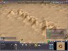
Interestingly, both base altitudes, water or land, can have peaks and hills. Just for fun I made the map script use peaks in the deep desert, and here is a screenshot. You can see the tips of the hill tops just peering above the water line!
No matter what happens, it would be nice to get rid of that visible water texture.
I can set land terrain below the water line with WB, but when you save and then load the game, all the land types in the 'lowlands' will raise above the water line and all the water types will sink below the water line. That means we can't use the low altitude for salt flats like I wanted.
Interestingly, both base altitudes, water or land, can have peaks and hills. Just for fun I made the map script use peaks in the deep desert, and here is a screenshot. You can see the tips of the hill tops just peering above the water line!
No matter what happens, it would be nice to get rid of that visible water texture.
Attachments
") .
.Deliverator
Graphical Hackificator
Could we make the water completely transparent so that you basically just see the sea bed? I suppose the problem would be units then looking like they're hovering in the air, but that might be fixable.
cephalo
Deity
Could we make the water completely transparent so that you basically just see the sea bed? I suppose the problem would be units then looking like they're hovering in the air, but that might be fixable.
Yeah, maybe we should leave it alone. It looks like I'm not going to be able to do some of the stuff I wanted.
cephalo
Deity
Alright, I'm not ready to give up just yet. The problem I mentioned is purely graphical. If I make a different xml tag on the terrain infos to denote land other than the existing one, we can still have 'land' in the ocean basin that will be recognized as land be the AI. The old bWater tag will be used by the graphics engine as normal, while the new tag will decide if the map plot is water or land. That should work! That way we can have salt basins that are actually basins instead of plateaus.
cephalo
Deity
Ah it's no good. I succesfully made it so that units and improvements could use the low land, but there's alot of important stuff that's not happening when you try to place a city on the lowlands. The city buildings don't show up and none of the tiles are workable. I may have to just make do with what we have.
Lord Tirian
Erratic Poster
The former is due to the CityLSystem and can be changed as far as I know and the latter is due to the lack of the unlocking technology - just give out the water tile working tech as start tech.The city buildings don't show up and none of the tiles are workable.
Cheers, LT.
cephalo
Deity
The former is due to the CityLSystem and can be changed as far as I know and the latter is due to the lack of the unlocking technology - just give out the water tile working tech as start tech.
Cheers, LT.
Thanks LT, maybe there's a mod out there that places cities on ocean that I can look at.
The thing about working those tiles, I have the CvPlot::isWater function return my new flag for whether something is land or not. It should be viewed as land in that sense.
cephalo
Deity
Well, maybe I don't want to be adding a whole bunch of complexity just to have lowland tiles. For now at least I'm going to work on a playable version of the map script, with the best tiles at the pole.
Deliverator
Graphical Hackificator
Another playable version would be cool, seeing as version 1.3 of the mod is not far off.
Water for Food is now implemented so if you want we could have a Polar Sink terrain than has a higher food (water) yield.
Water for Food is now implemented so if you want we could have a Polar Sink terrain than has a higher food (water) yield.
Similar threads
[Map Script]
Continental Drift Map Script
- Replies
- 27
- Views
- 5K
- Replies
- 0
- Views
- 433
- Replies
- 0
- Views
- 264
- Replies
- 3
- Views
- 686