Hex Grid

Akkon888

한국 사람
Joined
Mar 20, 2009
Messages
358
Location
서울
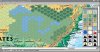
I was messing around with Paint.Net today, and decided to make a hex grid similar to one that may be seen in Civ5. It is in the attachment below.

The grid is not actually made of hexes, but it does imitate what would be the movement pattern for units in Civ5. My grid has 507 tiles, which surprised me. It seems that 1000 tiles in a game would be sufficient now.

Anyway, just thought I'd post this and let people have fun with it.

Edit: Created a new hex grid, with 120000 tiles. :eek: :eek: :eek: :eek: See post 14 for the attachment.
 

Attachments

  • Hex Grid (507 T).png
    Hex Grid (507 T).png
    6.8 KB · Views: 4,056
I have played on hex grids for nearly 50 years, yes most of that was on Avalon Hill type Board games. Hex jus does spatial relationships so much better than squares
 
Also, remember to turn it sideways before you make any maps else you will have to fix them later by distorting them.

East-West is one of the straight line directions - not north-south.
 
I think he is trying to demonstrate how squares can be used in place of hexes, but offset from it's neighboring row to get all the benefits of hexes? i think?

Problem is graphically that would look horrible... and... why the heck are you so dedicated to squares that you would do this!?
 
This reminds me of a while back when I programmed a couple of bots to play the game of Hex.
For a command line output (before a GUI was made) it was perfectly adequate to use an ordinary square grid but you had to know which diagonals corresponded to adjacency.

e.g.
Code:
+----+
|XO[COLOR="blue"]X[/COLOR] |
| O[COLOR="blue"]XX[/COLOR]|
|OOO[COLOR="blue"]X[/COLOR]|
| O[COLOR="Blue"]X[/COLOR] |
+----+
is a game where X managed to connect the top and bottom of the board.
Before long it was second nature to look at square grids that had different adjacency rules.

I just had the thought that in Civ4 you could emulate a hex grid by simply disallowing all movement on the northwest to southeast axis (or the other diagonal axis, but not both obviously). I wonder if that would be a cool little experimental mod to try, and I wonder how difficult that would be.

I'm no expert on Civ4 code, but this is a pretty standard way of representing hex grids in algorithm competitions. And it is just as easy to relate to (code-wise) as square grids.

If Civ4 adjacency isn't hard-coded into the game, it is of course trivial to change. I have my doubts on that one, though. If it is hard-coded (in path-finding, distance calculations, etc.), you'd need to locate every single place a square grid is assumed and change it there.

Other than that, you get some issues with city BFC and graphical representation. What would be the scope of such a mod? Which things would you want to change?
 
My guess is that the adjacency rules are hardcoded in some places and not in others. For example, I remember seeing two functions for distance calculations (i.e. one for unit movement and the other one counting diag distance as 1.5). So most distance calculations are probably not hard coded if those two functions exist.

As for graphical issues, they would not be a great concern if this were to be a small experimental mod. For things like BFCs etc., yeah, something would need to be done. My first thought is to simply stick with the BFC as being the 2-radius ring of a hex grid where there are 6+12 tiles in the 2 rings and the centre tile in the middle. This is almost the same as the square-grid BFC.

At this point this is just me wanting to experiment. Don't assume I'm intending to create a quality mod out of this. :)
If I or someone had time to do this mod, and if it worked, it might give us some insights into how civ would play out on a hex grid, but those playing it would need to keep an open mind about the graphical representation and not get frustrated with their new movement restrictions and weird BFC shapes etc.
 
I think he is trying to demonstrate how squares can be used in place of hexes, but offset from it's neighboring row to get all the benefits of hexes? i think?

I'm not sure what the OP is trying to show, but using a square grid with every other row or column shifted, (or assumed to be shifted) is a shortcut to designing a hex map if you don't have a hex grid available. For instance if you are using paper, or if you are using an image file with 1 pixel per tile.

I show how that works in this post.
 
Yes, I was taking a shortcut. I do not know how to quickly produce hexagons using my paint software.

With that being said, I know that my original grid may have lacked the amount of tiles neccesary to create many maps. So, I took about 15 minutes copying and pasting a new grid, of about 120000 tiles. :eek: :eek: :eek: :eek: Trim the page size if you wish.

Just curious, does anyone know the amount of tiles the largest Civ4 map contained?
 

Attachments

  • Hex Grid (120000 T).png
    Hex Grid (120000 T).png
    4 KB · Views: 354
Big waste of time to make empty hex maps in Paint! There's already software for making hex maps.

This is one of my favourites, but it's difficult to find:

http://www.enworld.org/forum/general-rpg-discussion/241913-looking-aks-hex-mapper.html

It has its own tileset but you can also make blank hexmaps (in bmp format) or superimpose a hex grid on an image. It won't do a 200 x 200 tile map, but it will do a 150 x 150 tile map (that's 22500 tiles)

The tileset is made up of images that are stored in bmp format as well, so, if someone designed something that would convert bmp images into game maps, you could set up coloured tiles to be read by the converter and paint them overtop of the underlying image.

Here's a 104X73 tile map of North America, with a hex grid superimposed. I've also included a cropped part around the Great Lakes where I filled a few cells with terrain.
 

Attachments

  • GF075.jpg
    GF075.jpg
    591 KB · Views: 199
  • Clipboard01.jpg
    Clipboard01.jpg
    276.3 KB · Views: 611
Back
Top Bottom