You are using an out of date browser. It may not display this or other websites correctly.
You should upgrade or use an alternative browser.
You should upgrade or use an alternative browser.
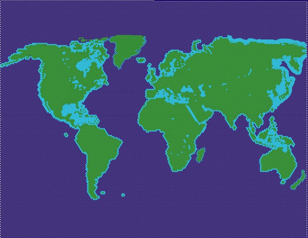
Hexagonal Map of EARTH!!!
- Thread starter GigaNerd
- Start date
Ahriman
Tyrant
I never understood why some regions got so dominant in history? Why did Afrika and the Americas develop so slow compared to Europe and Asia?
Try reading Guns, Germs and Steel by Jared Diamond. His argument is basically that the East-West continental shape allowed better trade and growth of ideas (not blocked by bands of desert or jungle), and that the fertile crescent, India and China happened to be blessed with particularly valuable domesticatable animals and crops. Horses, cows, pigs, sheep, wheat, barley, rice etc.
Zebras and Llamas just aren't as useful animals, and corn isn't as good a staple crop as wheat or rice.
So basically; climate and natural resources.
But Diamond is a Geographic Determinist; some cultural determinists place more impact on institutions and technological developments.
* * *
The British Isles are certainly not longer than France is and New Zealand is hardly the same length as Australia.
Umm... yes they are. Check a map. UK is noticeably further north-south than France is (but much less wide)
And New Zealand tip to tip is almost Melbourne-Cairns, which is about right for those maps. Trust me, I've driven it
")
That's my point - France is actually much longer than the British mainland, but the map proportions are historic, rather than accurate.
Edit: My best Google-fu puts Le Havre to Marseille at 500 miles and Portsmouth to Aberdeen at 440, if that.
Edit: My best Google-fu puts Le Havre to Marseille at 500 miles and Portsmouth to Aberdeen at 440, if that.
Tomice
Passionate Smart-Ass
Come on, guys!
Some folks here try their best to give us an idea how the world would look like in hexes, and yo complain about details. I feel very enlightened by this pictures, it gives a much better feel for how hexes affect the shape of the game world (not only the real-world maps)
Some folks here try their best to give us an idea how the world would look like in hexes, and yo complain about details. I feel very enlightened by this pictures, it gives a much better feel for how hexes affect the shape of the game world (not only the real-world maps)
Tomice
Passionate Smart-Ass
Try reading Guns, Germs and Steel by Jared Diamond. His argument is basically that the East-West continental shape allowed better trade and growth of ideas (not blocked by bands of desert or jungle), and that the fertile crescent, India and China happened to be blessed with particularly valuable domesticatable animals and crops. Horses, cows, pigs, sheep, wheat, barley, rice etc.
Zebras and Llamas just aren't as useful animals, and corn isn't as good a staple crop as wheat or rice.
So basically; climate and natural resources.
But Diamond is a Geographic Determinist; some cultural determinists place more impact on institutions and technological developments.
* * *
Umm... yes they are. Check a map. UK is noticeably further north-south than France is (but much less wide)
And New Zealand tip to tip is almost Melbourne-Cairns, which is about right for those maps. Trust me, I've driven it
I would love to play a civ4 world map shaped after your ideas now! ;-) In fact, I never played world maps that often because I hate the idea of european civilisations exterminating each other in bronce age wars and the lategame being a conquest of the inca, polynesian and zulu mega-empires.
Not that I want those people to never win, it's just not the purpose of playing a realistic map when it doesn't allow to replay history to a certain extent.
When traveling africa (kenya and tansania) i was surprised how fertile many areas appeared. I believed the poorness of these countries will directly relate to their geography...
Ahriman
Tyrant
Edit: My best Google-fu puts Le Havre to Marseille at 500 miles and Portsmouth to Aberdeen at 440, if tha
Le Havre to Marseilles is on a diagonal. If you're allowing that then you should measure UK diagonally.
Also, Aberdeen is not on the northern tip; Orkney is ~100km north of Aberdeen.
More importantly, the UK is of such historic importance that it needs to be large enough to support multiple cities. This is a far more important feature than exact geographic accuracy.
The maps look good!
Come on, guys!
Some folks here try their best to give us an idea how the world would look like in hexes, and yo complain about details. I feel very enlightened by this pictures, it gives a much better feel for how hexes affect the shape of the game world (not only the real-world maps)
man thats soo true.... where is the love? GigaNerd and Mef, bigup to you mans. Kudos! It is easy to just look at those maps and not understand how much work and time has gone into it. A little negative feedback never hurts more than stick and stones but we should all at least show our appreciation for their hard work.
Feedback: japan still looks sadly tiny... i wonder how it would actually work in the real game
I agree with you on the historical relevance, Ahriman, but the British mainland is such a silly little triangular mess, that it's almost impossible to get a straight line  The Orkneys and the Shetlands are also nowhere near the mainland
The Orkneys and the Shetlands are also nowhere near the mainland jesus! how long do you guys spend on this?!
A map like this doesn't take long to create. You only need to trace the shapes of the continents and then fill the rest with green or blue.
A real map in the game will take much longer obviously, with all the different terrain and resources...
@ Mef
How many hexes does that map have?
I don't know, why don't you count them?
")
@ Mef
Sweden is made a tad odd. I can understand why you might want Zealand in, but if that is the case it should be closer to Jutland so you can make Skåne too. All in all you actually lack Skåne on the map. If it is a reference to that neither Denmark or Sweden want that place I don't know.
There are a lot of areas on a world map which are debatable and I'm thankful for every input I can get (I plan to make a world map for Civ V).
What do you think, should Skåne, Sjælland and Jylland be connected, like the Japanese Islands?
This would create a bridge between Central Europe and Sweden, and that's maybe not very desirable because you don't want to see Germany in Sweden.
But, I guess, historically it would be adequate to have a connection between Denmark and Sweden. Additionally, these regions are very close and hard to represent in a world map if you want to keep them seperated.
Post 5 looks fantastic, but is probably way too big to be playable.
Actually I want to make a bigger map if it's possible.
And I'd be VERY disappointed if a map the size of my draft would run too slowly. The game should be able to handle big maps...

Ahriman
Tyrant
he Orkneys and the Shetlands are also nowhere near the mainland
?
The closest part of the Orkneys (Muckle Skerry) is less than 6 miles off the coast of Scotland.
Shetlands and Faroes are a ways off.
Perhaps you are confusing which is which?
I'd say that you shouldn't be able to get to get to Scandanavia from Central Europe by land except *maybe* through Denmark. (A 1 hex spot at Copenhagen can act as a naval bridge to the Baltic if there is a city there).What do you think, should Skåne, Sjælland and Jütland be connected, like the Japanese Islands?
I'd be very surprised if it wouldn't be very slow. The map is gargantuan.And I'd be VERY disappointed if a map the size of my draft would run too slowly.
I'd be very surprised if it wouldn't be very slow. The map is gargantuan.
In Civ IV it would be slow, but in Civ V a map this size should (at least I hope so) run smoothly.
Multi-core support alone should make a big difference and with combat changed from stack vs. stack to front lines, the game needs to support big maps...
The scale is way too small and the hexes are arranged the wrong way.
I made a bigger scale draft of a world map in an earlier thread back in February (a lot of islands are missing).
Thankfully the edges will look a lot less sharp in the game.
How is Isle Isabella on the map but hawaii not?
How is Isle Isabella on the map but hawaii not?
This is not an actual world map for the game, it's just a draft, mainly to see how the continents look on a hexmap.
A lot of islands are missing, terrain varieties are missing, resources are missing, and so on.
KrikkitTwo
Immortal
- Joined
- Apr 3, 2004
- Messages
- 12,418
.
A bit off-topic: I never understood why some regions got so dominant in history? Why did Afrika and the Americas develop so slow compared to Europe and Asia? Those maps in civ always bring up this question for me...
Read "Guns, Germs, and Steel" by Jared Diamond, interesting theory on that (also explains why sub saharan africa was dominated by 'blacks' from West Africa as opposed to Pygmies from the Congo, or Khosians (sp) from S Africa.
Basically it was the food supply (middle east got a good resource starting spot) and how easily it could spread.
edit:Ahriman beat me to it.
Basically more pop=more power AND more tech
With the lack of a Viking Civ then Germany would be the desirable Civ to have up there, mostly because of the common culture. Else you could just place the Viking start position in Denmark or Sweden (Alternatively have the tree countries as separate city-states).There are a lot of areas on a world map which are debatable and I'm thankful for every input I can get (I plan to make a world map for Civ V).
What do you think, should Skåne, Sjælland and Jylland be connected, like the Japanese Islands?
This would create a bridge between Central Europe and Sweden, and that's maybe not very desirable because you don't want to see Germany in Sweden.
But, I guess, historically it would be adequate to have a connection between Denmark and Sweden. Additionally, these regions are very close and hard to represent in a world map if you want to keep them seperated.
I think having Jylland, Fyn, Sjælland and Skåne connected would be a really good idea actually. While Denmark is an island kingdom then you cannot represent that on a world map - at least not properly. If rivers work anything like in Civ 4 then you can put a river all around Sjælland & Fyn to represent them being islands (Wacky idea I know).
To make the bridge work you need to make Copenhagen/Roskilde an attracktive place to make a city since you want the Baltic to be connected to the sea (This could even represent the Sound Toll!).
I think having Jylland, Fyn, Sjælland and Skåne connected would be a really good idea actually. While Denmark is an island kingdom then you cannot represent that on a world map - at least not properly. If rivers work anything like in Civ 4 then you can put a river all around Sjælland & Fyn to represent them being islands (Wacky idea I know).
It's not a wacky idea, I did this in some of the maps I made for Civ IV, but it looks really ugly with the way the rivers look in Civ IV. From the screenshots it seems like this will look much better in Civ V.
To make the bridge work you need to make Copenhagen/Roskilde an attracktive place to make a city since you want the Baltic to be connected to the sea (This could even represent the Sound Toll!).
Ideally, city states will be freely modable which would allow for Copenhagen or other Skandinavian cities to be included in the map. But that remains to be seen.
This is not an actual world map for the game, it's just a draft, mainly to see how the continents look on a hexmap.
A lot of islands are missing, terrain varieties are missing, resources are missing, and so on.
I know, but how is the world did you create a map that somehow included isle isabella and NOT hawaii?
I know, but how is the world did you create a map that somehow included isle isabella and NOT hawaii?
I just added some random islands and then stopped, because it's not really worthwhile to add all islands to a rough draft.
Similar threads
- Replies
- 62
- Views
- 3K
- Replies
- 1
- Views
- 2K