in case you want to release an updated version of the map, here's my two cents worth of suggestions:
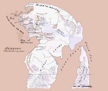
1) In the very north, there's that bay at the north coast of Eriador. It's the bay of Forochel and the entire area south of it was described as an icy waste. So I'd put tundra there, not lushy green forests and grassland.
2) the area in northeast Eriador, west of the Misty Mountains, there was very little population throughout the ages and the terrain was called the "weathered heath". IMHO Plains would be best.
3) Most Gondorians lived in Anórien (west of the Anduin between the Entwash and Minas Tirith) and in the western part of Belfalas, which appears to be rather crunched.
4) The lands east of the Anduin were called "The Brown Lands" because Sauron had scorched them at the end of the second age, and nothing grew there except for hard weeds. Plains would be good to represent this area, as it could have been turned into something arable.
5) The Morannon, the gate of Mordor, was a natural opening between the Ephel Duath and the Ered Lithui, the mountain chains forming the northern and western border of Mordor. Udûn and Barad-Dûr look cool on your map!
6) The Ered Luin and Mirkwood are quite big on your map. Between the Ered Luin and the western coast of Gondor, there should be room for the coasts of Enedwaith and Minhiriath... the rivers Greyflood (flows near Imladris) and Isen actually both have their own estuaries into the sea, while they seem to flow together on your map.
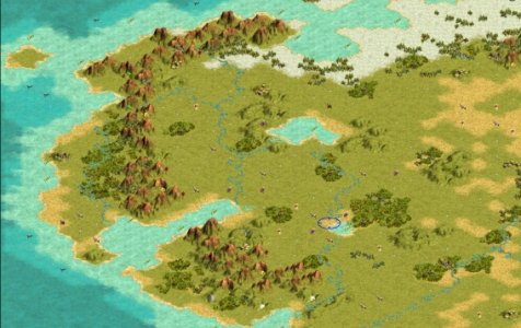
But that map is already fun to play! I'm just missing that one hill for Moria, but I already modified the map a little to make that possible. (I made it so you can set up Moria as a link between the eastern and the western side of the Misty Mountains. I carved a little valley out of the eastern side...)


 Yes, elves like bows
")
 . I also have some interesting (well, at least I think they are) suggestions for a Tolkien scenario/mod pack, I just wasn't sure if this was the right place to post them (since this is a forum about maps
 ") )
)