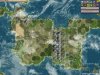
#1: While this may look like an island bridge, it is nowhere like the ones you mentioned because of its horisontal orientation. Were it vertical, it might have looked far more natural. But this one looks like it's a Panama stuck to Virginia instead of Mexica (while the continent itself has a neat southern horn which would most certainly suit this "bridge" better. If only the two continents were aligned vertically, not horisontally.
I see your point, but to me there's no reason why the orientation of such a land bridge should be north south. I see nothing in tectonics plate theory that would explain why such bridges should be NS. In a few hundreds of millenia, New Guinea will probably be an EW bridge for instance.
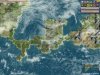
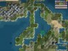
Which is what seems to happen all to often with this script. See #3 and #4 - there are continents which are pronouncedly horizontal themselves, especially the lower one at #3 and the upper one at #4. The latter is even more strangely located at 90 degreed to its neighbour (with a rather queer intersection - two bridges forming an inner sea).
I don't see this as a problem but
Can this script be made to prefer more earthlike vertical continents?
Yes. Though I wouldn't do it in general (Asia is kind of EW).
Modifying the neighbour() function around line 500 could help with that.
Untested, you could replace this bit (and the same for right):
Code:
		left = self.plateMap[leftX + y*self.mapWidth]
		if (left != 0):
			if (roll <= self.plateSize[left]):
				return left
with:
Code:
		left = self.plateMap[leftX + y*self.mapWidth]
		if (left != 0):
			if (roll <= self.plateSize[left]):
				if (i >= self.numSeaPlates and self.dice.get(10,"less horizontal continents") > 5)
					return left
			else:
				return left
You'd probably have to play with the 5 value in order to get something between horizontal blobs and vertical one line strips.
And both horizontal continents are pushed to the extreme sides. Which to me seems like another frequent displeasing feature of this script. Can it be made to simulate a more earthlike pangaea division with continents occupying the more or less central parts of the globe?
The continents are currently slanted to appear mostly in one hemisphere (can be N or S, real Earth is North if you forget the unpleasant Antarctica which is not in the central part). This can be turned off by removing stuff around line 225 in get Coord function : Remove all this:
Code:
		if (i >= self.numSeaPlates + (self.numContinents/3)):
			y = 2 + self.dice.get(2*self.mapHeight/3,"y seed for plate")
			if (i >= self.numSeaPlates + 1 + (self.numContinents/3)):
				if (self.mostLands == 0):
					y = self.mapHeight - y - 1
			elif (self.mostLands == 1):
				y = self.mapHeight - y - 1
		else:
Also remove one tab on the next line. The result will be more spread out. If it's still too near the poles to your taste, you must replace the aforementioned block with something like:
Code:
		if (i >= self.numSeaPlates + (self.numContinents/3)):
			y = self.dice.get(self.mapHeight,"y seed for plate")/2 + self.mapHeight/2
		else:
And also the same two continents are far too narrow for their size, to my taste. It doesn't look natural either. Same is true for the smaller continent in #1 - it does not seem to be a full continent connected to the larger one via an island bridge either - instead, it is more like a loose outgrowth of it (which in turn raises the question of why it is there if it is not bridged continents, after all).
It is there because of plate boundaries. I tried to minimize these occurences but got too much water. It's not that easy to tweak unfortunately.
One way to achieve it might be to change the generate() function around line 200 by changing the self.movePlates(false) to self.movePlates(true), or, if that's not enough, by removing the self.erode() and self.movePlates(false) altogether. Both solutions, particularly the latter, would also create less hills and peaks however.
I suppose I could have just summed it all up as: can you please make your script produce not only earthlike terrain but also more earthlike continent placement and outline, too? Fatter continents (vertically-oriented if elongated and/or linked via an island bridge) closer to the equator and with less "outgrowths" (i.e. big offshoots which suddenly grow fatter than it would suit a continental "tail").
Did you try the Terra option? This one may be too Earthlike since it's predictably the same number of continents.
I'm not committing these changes to the script because I personnally prefer the script the way it is. I may add options if that seem to workn but options mean more clicking around or I should devise a better UI than the one provided by default.
 . The problem is though that there is still thundra in the map, is there some other function that causes this or something?
 ...
...")