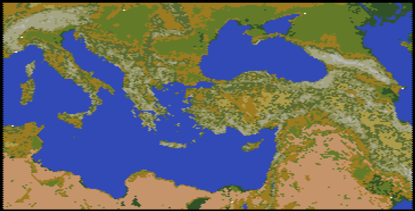
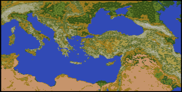
@Konig15 Well... I may never be truly satisfied with this map, but I feel like it's at least halfway decent, so I'm going to post it and see what you think. (Actually if anyone else reads this thread and wants to offer feedback too, please do so!)
The map size is 180 x 182 for a total of 32,760 tiles.
I ended up using all of the base terrain types.

There are a few key things to note:
- "Grassland" should be changed so that mining it produces "Jungle", not Forest (see differentiation of those below).
- "Forest" is used for rugged upland forest (mostly coniferous) so it should probably be renamed to "Pine Forest" and may need a different graphic.
- "Tundra" is used for High Plains. It would benefit from a different graphic (perhaps a lighter or more yellow version of Plains?), but the stats for Tundra are fine.
- "Glacier" is used for extremely high mountain peaks, normally snow-covered. I'd recommend setting this terrain to be Impassable to most military units.
- "Jungle" is used for flat lowland forest (mostly deciduous) so it should probably be renamed to "Broadleaf Forest" or something similar and also needs a different graphic. I'd recommend changing the stats of this in Rules.txt to exactly match those of the Forest terrain, except that irrigating it should change it to Grassland instead of Plains.
Special terrain resources will also need to be edited to align with those changes, with the geographic region of the map, and perhaps with the historical era of the scenario. For a realistic scenario set in pre-modern times, I'd recommend removing the transform or terraform capabilities entirely.
TOTPP adds support for 5 additional terrain types (16 instead of 11) which are
not used on this map, so that amount of expansion or flexibility is still available. For example, you might want to create a type that's even more fertile than Grassland, and place it strategically near large cities to support their historic sizes/growth. Note that those TOTPP extra terrain types have to be placed in the game itself, using cheat mode -- the map editor doesn't recognize or support them.
I added a few rivers, but more are probably needed (this is the area of the map that I'm least satisfied with). The ones I added are:
Po, Danube, Kizilirmak, Euphrates, Tigris, and Nile.
I would have liked to add more, but getting the placement of rivers correct is pretty time-consuming and I was just running out of steam to work on that aspect of the map.
I tried to pay attention to the number of tiles using each terrain type, in order to create a balanced map. Here's the final tally (percentages are relative to the total number of
land tiles on the map; note that overall 65% of the map is land and 35% is water):
- Plains: 21.5%
- Desert: 21%
- Forest: 15% (coniferous forest)
- Jungle: 11.5% (deciduous forest)
- Hills: 11.5%
- Mountains: 7.5%
- Grassland: 5%
- Tundra: 3.5% (high plains)
- Swamp: 3%
- Glacier: 0.5% (mountain peak)
I hope this map is useful! I hereby grant permission for any designer to use this map for a scenario, with as many edits as you deem necessary. All I ask is that you document the map source somewhere in your Readme or credits.
View attachment 607963
 Here's a glimpse of what I've got so far... still some more work to do, though, before I'm ready to post a final map. Thanks for your patience!
 Here's a glimpse of what I've got so far... still some more work to do, though, before I'm ready to post a final map. Thanks for your patience!

 There are a few key things to note: