Guatenadian
Prince
I would say add some of the land of the Woods Cree, Poundmakers Agenda directly references the Iron Confederacy and the Iron Confederacy was primarily made up of the Woods and Plains Cree.

I think technically we could examine treaties between the British/Canadians and the Iron Confederacy. While we can question the legitimacy of some treaties or wonder if legal and effective control are different, it's at least a starting point. Here is the Treaty 6 that Poundmaker helped negotiate:
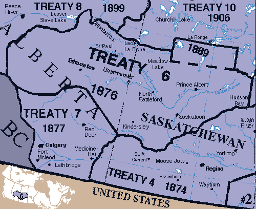
It's certainly possible I'm misreading the map, but I think this is what it conveys. The territory being negotiated by the First Nations' Federation is marked Treaty 6. In exchange for schools and medicine, the Federation would cede sovereignty to the Queen. The Canadian government would reserve land, that is unfortunately not marked. The "Medicine Chest" clause is a big deal because it was interpreted differently by both sides. The First Nations believed it meant the Canadian government would provide healthcare in perpetuity because the introduction of Small Pox to the area was a major reason they signed the treaty.
I would mark the Iron Confederacy territory as all of Treaty 6, though it's up for interpretation. One could limit the Cree to just the reservations (which I frustratingly can't find) or argue that losing sovereignty in the treaty means they cease to exist as holding territory. I personally chose to mark it as the Treaty 6 boundaries. This also seems to fit where the theater of operations was during the North-West Rebellion (which seems to have a problematic name, but whatever).
Here is another map of the Cree for that time period that places them a bit farther south during the North-West Rebellion. There are no borders in this one, unfortunately. At first I thought the rivers were borders, but that was just wishful thinking on my part.

Ok spent the morning working on Georgia for the new map (which will come out of release day) and well The Middle East is getting hella crowded

And there's still Ottomans/Byzantines to cram in there eventually.
Well just wait for Babylon, Palmyra, Phoenicia, the Ottomans, Byzantines, Assyria etc...Ok spent the morning working on Georgia for the new map (which will come out of release day) and well The Middle East is getting hella crowded

 ). I believe the answer to that would be Ed himself
It would be a bit odd, like Auckland being in the Australia city list, even though NZ was technically run from Australia for a bit


I've only just now looked at your City placement list @bite; and wow! Incredible job
Regarding your comment on Germany/HRE - "However, it is also quite clear that someone on the Firaxis team really likes their reformation history" I'm surprised that no one has had a stab at your comment in this thread (unless I missed it scrolling through five or so pages in the wee hours this morning
To be exact... we were never run from Australia cos that country did not exist at the time
We were run from that unplayable faction in the Australian scenario - New South Wales. And as our parliament is 50 odd years older than Australia's...we are the older country
")
I've been trying to note the City names of the R&F Civs, and I think this is the most suitable thread to post them. Let me know if I missed any names.
Spoiler :CreeSpoiler :(since the Cree aren't known for their cities, Firaxis is using the native names for the reserves)
Mikisiw-wacîhk
Piyesiw-Awasis
Mistahi-Sipihk
Pihtokahanapiwiyin
Mistawasis
Paskwaw-Askihk
Georgia
Tbilisi
Tskhumi
Akhalkalaki
Kaspi
Kutaisi
Rustavi
Batumi
Zugdidi
Gori
Korea
Gyeongju
Chuncheon
Gwangju
Sangju
Jinju
Seoul
Jeonju
Daegu
Yangsan
Gongju
Mongolia (an improvement over the Civ5 list)
Qaraqorum
Qaraqoto
Aksu
Urumqi
Hami
Almaliq
Kokeqota
Ulaanbaatar
Qarabalghasun
Choir
Netherlands
Amsterdam
Arnhem
The Hague
Haarlem
Rotterdam
Utrecht
Tilburg
Eindhoven
Nijmegen
Groningen
Maastricht
Apeldoorn
This might not be among the most valuable contributions to this thread but I really think there should be an achievement for using an Apostle or Missionary on this city when it's already following your religion, called "Preaching to the Choir"Mongolia (an improvement over the Civ5 list)
Choir

@bite isn't it time to update this post's title? As far as I know, the mapping has been continued past the Nubia DLC. Might attract more 'viewers' that way ;-) I myself am a junkie for maps and map data. It's even part of my profession, as I'm a traffic and mobility engineer. Love to see the updates and am looking forward to R&F maps ;-)
Very interesting stuff - kudos!
For the purposes of analysing how represented a region is though, these colour blob maps aren’t very helpful. In pure game terms, the civs are the cities that they inhabit and no more. They represent the core culture and political entity that leads the empire in question. For example, your map gives the impression Central America is full, but their is not one Central American city on the spanish city list. It’s conquered territory, not part of the Spain that Civ is representing.
I would be very interested in seeing a map with only data points for cities on it, and all the cities for all the civs (no city states). I think that would be a fairer and very interesting way of viewing Civ distribution
Good point, I forgot to update it with SEA, though there will likely be a new thread once R&F is out
I tossed around about doing a map of just cities but it soon became apparent that it was not going to work just with America let alone those civs that overlap. This is why I have the individual city maps, the big map is the all in everything goes, but in the city maps it is just the core components.
I tried out a map where I put every city for every civ on the same map, now before I committed myself to this I did a test mock up with just American cities.
With only American cities (and this is a civ with no overlap with any other civilization atm) it soon became a complete mess because of the number of cities in a the same area. Now add to this somewhere like Greece where there is three different civs in the same area, and civs like The Aztecs and Khmer where most of the cities are clustered in the one area, and a map like this becomes quickly impossible.
Now someone has set it up that they tagged every city on google maps, and that sort of works but even then it is too cluttered in places.
For the Netherlands I spotted "Batavia" the Dutch Name for Jakarta (Indonesia) during the Dutch colonial times at 1.09in the upper right corner.