Playable real Earth map 130x130 with correct resources

Veryeager

Chieftain
Joined
Mar 15, 2003
Messages
15
Location
Russia
Forgive for not-so-nice English.

Introduction

It is interesting for all to play on the "Real Earth map". More size of a map - more opportunities for approach to reality, therefore the map-makers increase the sizes of maps up to the unimaginable sizes (for example 362x362: http://forums.civfanatics.com/showthread.php?threadid=44762). In result - to play on such map becomes almost impossible. Empires are too big, to manage of all your cities is out of human abilities, the computer must be very fast.

If to reduce the size of a map with keeping "real" proportions of continents, then, for example, Britain and Japan (or Germany, "restricted" by France, Italy and Russia) receive too small opportunities for initial development and are in a not advantageous situation. Besides it is impossible to place in Europe many cities, therefore on such map it is impossible to create the good global scenario, where it would be taken into account the events of the European history.

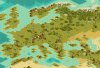
The decision of a problem consists in creation of the map, in which the relative sizes of continents and main islands are changed (at preservation of proportions of each continent), and Europe with Japan are increased, first of all at the expense of reduction of Northern territories of Canada, Alaska, of Greenland and Siberia (as their excessive sizes on many "realistic" maps are a consequence of use of the Mercator’s projection). An example of maps, where such attempt is made, are the Kal-el’s map (http://forums.civfanatics.com/showthread.php?threadid=39670); in his post he well explains his approach to map-making.

However his map (as well maps of all map-makers, which I have to view) suffers by a number of large lacks, which undermining the very idea of "realness".

Why the low and flat Ural mountains have turned to similarity of Hymalai? Why the Columbia river follows from the Big-Salt-Lake? Where the mountains of Western Iran have disappeared? Why Western Siberia is covered with hills and steppes (though actually it is absolutely flat plain entirely covered with woods), and where their huge oil fields? Why the most part of Russia is covered with tundra (and partially by steppes), instead of woods (as actually)? Why, on the contrary, the woods cover half of Australia (instead of steppes)? Why it is steppes on an Calimantan (Borneo) island which in reality wholly covered with jungle? Where is the rich oil fields in Venezuela, great iron deposits in Australia, large aluminium deposits in Guinea? Where is the oil of Indonesia, because of which Japan has entered the Second World War?... (The list can be continued and continued...)

...And why there are no spices in India on this map?!!! =:0 India without spices - it is Persian gulf without oil!!! :)

However, many other known maps (for example, famous Marla’s map and its modifications) are more worse in this respect.
 
In my map Europe and Japan are increased not only at the expense of reduction of the relative sizes of Siberia, Central Asia, Alaska, Greenland and South America, but also at the expense of some reduction of the area of oceans (though Galley still can not cross neither Atlantic, nor Pacific ocean - unless only in area of Alaska); the polar areas not playing roles in game are reduced also. Only real geographical zones and resources are taken into account. I placed mountains in areas, where actually they achieve height more than 2500 meters; lower mountains I considered as hills. Certainly, there are exceptions caused, for example, necessity to place the certain resource.

Certainly, all starting positions of civilizations are placed also.

Europe on my map 130x130 is more big (and more correct) than on a Marla’s map 255x205 - see pic.

I recommend that you set tundra as unsettlable (in map editor: Scenario/Custom Rules, then Rules/Edit/Terrain/reset "Allow cities") and reduce the corruption (Rules/Edit/Difficulty Levels).
You may to increase number of civilizations to 16 (standard for this size of map - 12): Scenario/Scenario properties/number of players.
 

Attachments

  • 130.jpg
    130.jpg
    16.6 KB · Views: 3,086
Well, this one looks significantly better than your 80 X 80 map.

South America is still squished a bit.

Asia still stretches too far south.

Africa still stretches in the west.

India is still too far south.

And North America is still stretched.

All though, aren't as bad.

I still personally would prefer Kal-el's 140 X 140 map over this one, despite the defects you pointed out. I can easily point out more on this one. :) But, I do COMPLETELY agree with you though about the inaccuracies of Marla's famous world map and the others which use the highly distorted Mercator projection.
 
You are right, but the distortions of outlines of continents are made consciously, according to a primary plan - to make a map more suitable for game. So, Southern America has not played of the large role in world history, and there is no start position on it. Therefore I have increased Northern America at the expense of Southern. Africa was stretshed in the west, because its width was defined(determined) in width of Europe and Mediterranian (and Europe was considerably increased).

By the way, in general it is impossible to achieve an exact outline of continents (even because any projection from the globe on the map brings in the distortions)! Therefore outline of continents always will be deformed. But the conformity to real geographical zones, mountains rivers and resources inside each continent is carefully observed in my map (as far as it is possible). You can try to find any little errors in this sphere, but you can not find such gross blunders here, as on Kal-el's map.
 
Give me time, I can find blunders on almost anything :p
 
Well let's see, Corsica isn't represented (though it could be).

Too many hills/mountains in Romania/Bulgaria.

I didn't know Lake Huron connected into Lake Ontario.

Or that Lake Ontario was so close to the Atlantic Ocean.

There isn't a major river that flows from Lake Erie to Lake Huron like that.

Lake Erie also is way too close to the Atlantic Ocean.

The Mississippi is too close to the Great Lakes.

The Appalachians are poorly represented.

The Mississippi and Missouri stretch way too far north (neither goes into Canada).

Alaska is completely distorted and seems to be tilted on its side.

Japan, while I realize you made it larger for playability, is MASSIVELY not to scale, and also seems to be tilted on its side.

The Arabian Peninsula is much too narrow, Persian Gulf too wide.

You kinda shrunk the Pacific too much, as you have New Zealand sitting under Mexico/USA????

Norway/Sweden is very distorted.

Ireland is too far north.

I will admit though, alot of your placement of terrain is very sound, and alot of the rivers and lakes elsewhere look good too. Europe on the whole looks excellent. In my opinion, Kal-el's still has the upper-hand but this map isn't as bad as I thought at first glance.
 
---------Procifica’s remarks
My answers

---------Well let's see, Corsica isn't represented (though it could be).

There is 2 small islands to the west from Italy. Northern is a Corsica, southern - Sardinia.

---------Too many hills/mountains in Romania/Bulgaria.

In complete conformity with a reality. About half of Romania covered with mountains (Eastern and Southern Carpathians); the most part of Bulgaria covered with mountains (Rodopy and Stara-Planina, or East Balkans).

---------I didn't know Lake Huron connected into Lake Ontario...
---------...
---------...The Mississippi is too close to the Great Lakes.

The area of Great lakes is very difficult for modeling on a map of such size (and this fact confirmed by Great lakes area on the Kal-El’s map, which contains almost all mentioned lacks). However, maybe I shall try to alter this area.

---------The Appalachians are poorly represented.

I agree. Maybe I shall to alter it.

---------The Mississippi and Missouri stretch way too far north (neither goes into Canada).

The Mississippi and Missouri in reality (and in my map) stretch to north to latitude of middle of Lake Superior. Canada is little bit to the north. By the way, on the Kal-El’s map Mississippi stretch far to the north, down to Vinnipeg lake :)

---------Alaska is completely...
---------...
---------Norway/Sweden is very distorted.

So was planned according to the general concept of the map. Concerning Arabia: to whom are necessary these deserts? But in my Arabia enough of oil. :) And maybe I shall correct it slightly.

---------Ireland is too far north.

Not too, but on one position. But I have noticed there one place, where Atlantic can be crossed on Galley. It should be corrected.

Probably it will be necessary to create the second variant of a map. Therefore I shall be grateful for the constructive remarks.

It is interesting, that there was no remark about resources.
 
I didn't look for resources when finding my "blunders"...didnt' need to :p

The Carpathian mountains though aren't as high as other mountain chains in Europe. And plateau areas should be represented with plains and/or pine forest, to give more variety and realism.
 
The lack of oil in Indonisia is a very good issue to be raised here. Almost all earth maps don't have Indonisian oil, and I always add it in my own games, but it's true, that's the real reason Japan attacked Pearl Harbor, and it should be represented on more earth maps in the future.
 
I have chatted a lot with Kal-El about projections. And we agreed that Mercator's and Miller's are the worse.
In my opinion your first attempt is very good, considering that it's a 130x130 map. But I think that it still need improvements (expecially on the shapes of the continents) to reach Kal-El's level. But I'm sure you can do it.

Now, some suggestions:

-quote: "Galley still can not cross
neither Atlantic, nor Pacific ocean - unless only in area of Alaska".
If there's one zone to cross the oceans, it's all useless. Remove it.

-16 civs in that map are too much in my opinion. Why don't you make a 160x160 version?

-Your criticism to other people's maps about steppes instead of for example jungle doesn't think about the coasts: often a plain or a grassland, or a desert is needed to better re-create the realistic shape. This is a bit unrealistic but surely better looking

-Why is America at the right? If you say that oceans aren't so important (a thing that I agree) then you shouldn't give the pacific the central position. It only shows how much is shrank.

-I see that you suggest changing some rules in the editor. What you suggested about tundras is only the tip of the iceberg. You could go into the problem in more depth. This is important, as rules and map choices are strictly connected to improve gameplay and realism. In my mod (see signature) rules changes are described in four pages of the readme.
 
Originally posted by Rhye

-quote: "Galley still can not cross
neither Atlantic, nor Pacific ocean - unless only in area of Alaska".
If there's one zone to cross the oceans, it's all useless. Remove it.

Being able to cross between Siberia and Alaska is more historically accurate. How do you think the "native Americans" got here? It's a good thing to include this, in my opinion.
 
Originally posted by Nagorak


Being able to cross between Siberia and Alaska is more historically accurate. How do you think the "native Americans" got here? It's a good thing to include this, in my opinion.

Yes, that's true. But when AI discovers America in 1000BC, where historical accuracy will be?
 
OK! I had time to make the corrected variant!

Now galley will not cross Atlantic, Appalachians is more high, and there are a lot of other little changes.

Download Playable Earth map 130x130 for classic CIV III Version 2:
 

Attachments

  • playable_real_earth_130x130_ver2.zip
    27.8 KB · Views: 168
Download Playable Earth map 130x130 for PTW Version 2
 

Attachments

  • playable_earth_130x130_ptw_ver2.zip
    33.2 KB · Views: 180
Im surprised about the lack of forests in europe.Europe used to be full of forests
 
TVA22 - The lack of oil in Indonisia is a very good issue to be raised here. Almost all earth maps don't have Indonisian oil, and I always add it in my own games, but it's true

My map 256x256 has oil resource in Indonesia. ;)
Give the guy sometime though, take a while before a map will be to everyone's liking.

keep up the good work - Veryeager:goodjob:
 
Top Bottom