Ribbentrop-Beck Pact - should Poland ally with III Reich

expediency can make lots of odd partnerships . Nazis would return to Lech hunting sooner or later but would a Germany without Adolf at the helm would similarly be aggressive ? A great mistake on part of Poland was allowing Adolf get away with the Chezchslovakia -apologies for spelling mistake , only because Germany could have been much better (hence dangerous) later in something like 1950s .

for any opposition to the notion that the Soviets could have been made to behave , all that was required that they would be in the fight .
 
This territory (red borders) was considered as Ukraine in the 17th century, as compared to modern Ukraine (black borders):


As you can see modern Ukrainian statehood expanded in all directions compared to historical Ukraine.

But it mostly expanded towards the western direction - mostly at the expense of Poland (the regions of Galicia and Volhynia).

It also expanded at the expense of Russia and territories historically conquered by Russia (such as Crimea).

==================================================

On the other hand, the part of historical Ukraine that today is part of Moldova (to the north-east of Iasi) is Transdniestria:

http://en.wikipedia.org/wiki/Transnistria

Transdniestria today (yellow territory - part of historical Ukraine, now part of Moldova which struggles for independence):

 
"Nah, they would go around Poland, never through it. Just like they did Belgium!

Actually, it's alternate history in which Poland built the best possible fortifications in all eternity.
 
This territory (red borders) was considered as Ukraine in the 17th century, as compared to modern Ukraine (black borders):


As you can see modern Ukrainian statehood expanded in all directions compared to historical Ukraine.

But it mostly expanded towards the western direction - mostly at the expense of Poland (the regions of Galicia and Volhynia).

It also expanded at the expense of Russia and territories historically conquered by Russia (such as Crimea).
Ukraine as a defined territorial entity only came into existence in 1917; how can you talk about "expansion" when there was nothing to expand?
 
Krain in Slavic languages is the same as March in Germanic languages. (Or close enough)

Anyway, the map is showing the borders of Ruthenia, a region of the Rzeczpospolita, versus the borders of Modern Ukraine.
 
Ukraine as a defined territorial entity only came into existence in 1917

This is not true.

Ukraine as a defined territorial entity came into existence in 1590 when this name was for the first time used in an act of Parliament.

From that point on this name was used many times and it denoted a defined territorial entity - for example in a map made by Polish cartographer Tomasz Makowski in 1613 and in a map titled "Delineatio Generalis Camporum Desertorum vulgo Ukraina" made by French cartographer William Beauplan in 1648, as well as in another map of the same cartographer in 1651, in which Beauplan defined Ukraine as territory between the Dnieper River and the Southern Bug River.

Finally, in 1658 the Treaty of Hadiach proposed to transform the Commonwealth of Both Nations into the Commonwealth of Three Nations consisting of three legal entities, thanks to creation of the Ruthenian Duchy in lands defined as Ukraine (Kiev Voivodeship, Bratslav Voivodeship and Chernihiv Voivodeship).

So your claim that Ukraine as a defined territorial entity came into existed only in 1917 is far from the truth.

My map shows the borders of Ukraine as defined in the Treaty of Hadiach in 1658.

However, the understanding of what area constituted the borders of Ukraine was similar throughout the entire 17th century. Initially - in 1590 - Ukraine encompassed areas of Kiev Voivodeship and Bratslav Voivodeship. In 1635 as the result of the Treaty of Polyanovka (1634) the Czernihiv Voivodeship was created from part of lands ceded to Poland by Russia in 1634 and that Voivodeship was also incorporated to territorial entity defined as Ukraine.

Certainly none of the lands which belonged to the Kingdom of Poland already before 1569 (since the 14th century) were considered as Ukraine.

In other words - the regions of Eastern Galicia, Volhynia and Podolia were never considered as parts of Ukraine.

=============================

Something about William Beauplan (in English):

http://mapy.muzeum-polskie.org/articles-about-the-collection/works-by-wilhem-de-beauplan.html

=============================

Another 17th century map of Ukraine was that by Vincenzo Maria Coronelli from 1690.

At that time Ukraine was already politically divided - one part was in Poland, the other part was in Russia. Coronelli called the Polish part of Ukraine "Vkraine ou Pays des Cosaques" and the Russian part "Okraina". In Coronelli's map Ukraine is limited from the south-west either by Southern Bug River (or by Dniester), from the north-west by Horyn River and from the north by Pripyat River. The Dnieper River divided Polish part of Ukraine from Russian part of Ukraine at that time.

Western Ukraine (within red borders) as defined by Coronelli in 1690 compared to modern Ukraine (black borders):


Original map of Coronelli from 1690:


Anyway, the map is showing the borders of Ruthenia, a region of the Rzeczpospolita

Not it is not.

It is showing proposed borders of the Ruthenian Duchy, which was to be located within the real borders of Ukraine, a region of Rzeczpospolita. That Ruthenian Duchy - a political entity, not a territorial entity (unlike the region of Ukraine, within which that political entity was supposed to be located) never came into existence, because provisions of the Treaty of Hadiach were annihilated by Russian intervention and Ukraine entered a historical period called "The Ruin":

http://en.wikipedia.org/wiki/The_Ruin_(Ukrainian_history)

In the article above we can see the borders of Ukraine in the 18th century - Right Bank Ukraine map and Left Bank Ukraine map:


Compared to Right Bank (Western) Ukraine according to Coronelli in 1690:


Both maps combined show the borders of Ukraine in the 18th century:


Not much change compared to borders of Ukraine in 1658 (red lines):

 
The old division between Polish (Right Bank) and Russian (Left Bank) Ukraine after 1650s has its traces still visible until nowadays:

However, of these 5 macroregions, only Center (Right Bank) and East-Center (Left Bank) were parts of historical Ukraine:


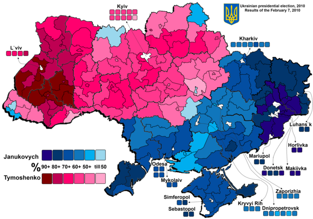
People in historically Polish lands (West) and historically Ukrainian lands (Center, East-Center) vote differently than the rest of Ukraine:


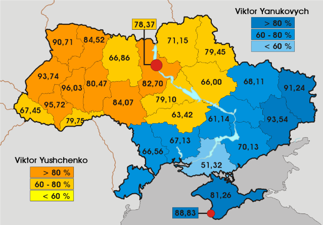
In 2004 presidential elections distribution of votes was the same - historical Poland + historical Ukraine voted for Yushchenko:


=======================================

Similar traces of Partitions of Poland still exist in Poland.

Judging from the map of Polish railways, you can easily draw the borders between Prussian partition and Russian-Austrian partitions:

To the south and east of red line = Russian partition (in the north) and Austrian partition (in the south):


The same basing on map of presidential elections in Poland (Russian: Congress Kingdom, Prussian: Duchy of Poznan, Austrian: Galicia):


And parliamentary elections in Poland (borders of Russian and Austrian partition zones can be seen):

 
I wonder where Domen got the impression that quantity of argument can substitute for quality.
 
Traitorfish:

When talking about Ukraine "as a defined territorial entity since 1917" - were you talking about Western Ukraine or Eastern?

In this thread:

http://historum.com/european-history/22023-ukraine-57.html#post1538269?postcount=568

User Andrey from Ukraine noticed - correctly - the fact that WUPR (Western Ukrainian Republic) wanted to be separate from the rest of Ukraine:

Andrey said:
Emperor Trajan said:
Andrey said:
Emperor Trajan said:
Domen said:
Emperor Trajan said:
Lviv was taken from Ukraine by war.
Not really.

The city became Polish in 1340 as the result of an inheritance agreement (signed in 1338) between King of Poland Kazimierz III the Great and Duke of Principality of Galicia Bolesław Jerzy II of Mazovia. Both guys - Kazimierz III the Great and Bolesław Jerzy II - were from Piast dynasty.
I am talking about the war in 1918.
Lviv was part of the Austro-Hungarian Empire, and Lviv had never been of Ukraine, before 1939 year.
http://en.wikipedia.org/wiki/West_Ukrainian_People's_Republic

http://en.wikipedia.org/wiki/Battle_of_Lemberg_(1918)

Yeah, I know, but it happened when the Austro-Hungarian Empire collapsed. And WUPR proclaimed itself as separate from the rest of the Ukrainian state.

So treating Ukraine as just one defined territorial entity in 1917 - rather than two separate entities - is wrong anyway.

As just one defined territorial entity Ukraine exists since 1939 - when the Soviets "united" (occupied) both parts of it.
 
Someone here was writing about the "liberation" of Vilnius in 1939.

Another short-lived liberation of Vilnius took place in 1990:

http://en.wikipedia.org/wiki/Polish_National-Territorial_Region

http://translate.google.com/transla...ia.org/wiki/Polski_Kraj_Narodowo-Terytorialny

And before that:

http://translate.google.com/transla...dniopolska_Socjalistyczna_Republika_Radziecka

======================================

The Polish National-Territorial Region (Polish: Polski Kraj Narodowo-Terytorialny) was an autonomous region in Lithuania, self-proclaimed by the local Poles on 6 September 1990. The region included areas surrounding Vilnius (Polish: Wilno), capital of Lithuania, where Poles formed the majority (60–90%),[1] This Eastern part of Lithuania had been part of Poland (from 1922) before being attached to Lithuania under the Mutual Assistance Treaty with the Soviet Union in 1939. The autonomy region with capital in Naujoji Vilnia (Polish: Nowa Wilejka) included 4,930 km² and population of 215,000 (66% of them were Poles and 34% in Naujoji Vilnia[2]). The Polish autonomist movement (the leaders of which included Jan Ciechanowicz) was related to the Yedinstvo movement and had tacit support from Moscow (thus, when following the Act of the Re-Establishment of the State of Lithuania the Soviets applied a blockade against Lithuania, the areas of Eastern Lithuania with significant minority population were mostly spared of the blockade, with the aim of gaining minorities' support for Moscow). In the region, the Polish Red-and-White flags were used as official flag and Rota was used as an anthem in the region.

The Lithuanian government declared the formation of the Polish autonomous district in Lithuania unconstitutional. After the August Coup of the Soviet hardliners had failed, the Lithuanian parliament suspended on 3 September 1991 the democratically elected local councils that had sought autonomy or secession from Lithuania.[3]
Despite all of post-1945 deportations - including the ethnic cleansing of Poles in Vilnius itself - Poles were still majority in the region in 1990. And they still are the majority in the countryside around Vilnius today (even though the city itself has been thoroughly ethnically cleansed from Poles).

Polish National-Territorial Region in 1990-1991 (excluding the city of Vilnius itself - as since the 1950s Poles were no longer majority there):


======================================

Here I posted the results of population censuses for the city of Vilnius in period 1897 - 2011, if someone is interested (post #416):

http://historum.com/european-histor...choslovakia-42.html#post1685987?postcount=416
 
Top Bottom