No they cannot.
Density of urban network (how many towns per - for example - 1000 km2) is a better indicator of population of the countryside than size of towns. Towns were output markets for the countryside (and inversely) - dense urban network indicated populous countryside. Size of towns was a secondary thing.
Even today large cities cannot be used as approximate indicator of overall population density.
In 1350 Rus had average population density of 2 people per 1 km2 (of course there were huge regional fluctuations*).
By comparison Italy & France in 1350 had average population density of 28 / km2 (regional fluctuations were smaller).
*Many regions of Rus were complete wilderness, while some other had population density of 10 / km2 or more.
That would seem quite a significant factor to me.
If I recall this correctly, based on recorded town privileges (keeping markets etc.), the German lands in the High Middle Ages time period in question, contained some 4000 towns. Since city walls were a defining feature of these, we should be able to assume that outside of more specifically dedicated fortresses and castles of various kinds Germany alone should have contained some 4000 fortified urban centers. Most of which would of course have been rather small, with only something like 50 of them having more than 5000 inhabitants (still, a quarter of a million people inside them). The thing is rather their ubiquitousness.
Italy and southern France at least showed a distinct pattern of fortified urban centers of varying size Milan at the very top of the food chain surrounded the agricultural lands servicing the urban center. The thing is, the agricultural population would cluster around the fortified urban center, and they certainly would head there for protection in time of war. Virtually all farmland was thus controlled by an urban center, of varying size.
You can clearly see this in southern France, where all these medieval villages and towns cluster on ledges along the river valleys, i.e. defensible and easily fortified positions, where anybody looking to do a spot of farming on the valley floors would have to climb down from the high ground alongside it, where people lived for defensive reasons. These place are usually godawfully windy, and the choice to live there certainly weren't made for practical reasons, but entirely for defense. It's a positively paranoid mixed urban-agricultural landscape, signalling the locals' of the times conviction someone was always suspected of being out to get them.
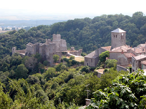
This is an example: Saissac castle.
Saissac is just one of these small medieval towns in Languedoc, placed on a tringular outcrop of the Black Mountan range above the river valley below, where the fields lay. The greenery hides the fact that below the castle is a sheer drop. The triangle shape of the outcrop means you can only approach the village from one side. That side was protected by a wall, with towers.
Once through that you were in the village. The villagers however would be further out on the outcrop, beyond the church. You can see the tower of the church to the right in the picture. The church is an integrated defensive feature. The wall against the village contains only arrow slits, and the body of the church is positioned so that it cuts off access to the castle, with just narrow walk ways on either side between the church and sheer drops. It's de facto a second wall.
Only past the church would an attacker be able to get to grips with the castle itself, first the outer wall and then the keep. That's a single approach, up in the mountains, town wall, fortified church, outer wall, keep four lines of defense. And that's just one small south French village. Nothing special really...

") )
)