W-I-P: Storm Over the Pacifc

yes, there will be some type of isolation. it will hinge on the 3 'region' resources: Industry, Imperialism, and Pacific Islands. then there'll be the country resources which will isolate some stuff. not sure i want to mess around with isolating rail and road connections just yet. not ruiling it out. just want to try and stay as organic as possible in the first versions.
 
some promised screens :

1 strat and lux resources. last lux shown is Spices. need to plug in bonus

2 i modified the eastern part of new guinea last night

3 japanese city gfx from AoI

4 size1 city @ iwo jima

5 aleutians
 

Attachments

  • strat and lux resources.png
    strat and lux resources.png
    26.3 KB · Views: 144
  • new guinea.jpg
    new guinea.jpg
    163.9 KB · Views: 200
  • japan.jpg
    japan.jpg
    160.6 KB · Views: 134
  • iwo jima.jpg
    iwo jima.jpg
    105.9 KB · Views: 160
  • aleutians.png
    aleutians.png
    413.5 KB · Views: 166
it dawned on me last night when reviewing new guinea geography that the dutch were beat by May 1942, the proposed start date for the scenario. will have to look at it more closely to see if the dutch get benched like the french.
 
it dawned on me last night when reviewing new guinea geography that the dutch were beat by May 1942, the proposed start date for the scenario. will have to look at it more closely to see if the dutch get benched like the french.

To be honest I think an epic scenario should have more than 4-5 civs. Although turn times are important, I think it would be more fun to try to simulate the war from the beginning(or at least 1941).
I think the original civ scenario tried to do this but wasn't very successful in terms of limited naval combat/troop deployment. With the ideas you've picked up from AoI, I think you could do a much better job of simulating the flow of battle.
 
thanks for the remarks. i'll be sure to change the chinese commies.

i've been working in the map over the last days, placing resources, modifying some geography, and adding some cities. attached are some screens.

1. Borneo and its oil

2. bottom part of Malay Peninsula and its abundant resources

3. Philippine Islands and surrounding area
 

Attachments

  • PI.jpg
    PI.jpg
    128.7 KB · Views: 109
  • malay peninsula.png
    malay peninsula.png
    298.1 KB · Views: 138
  • borneo.jpg
    borneo.jpg
    163.4 KB · Views: 123
more:

4. SE Asia

5. Soloman Islands and eastern part of New Guinea

6. Japanese stronghold at Truk and surroung islands
 

Attachments

  • se asia.jpg
    se asia.jpg
    286.3 KB · Views: 161
  • solomans.jpg
    solomans.jpg
    144.6 KB · Views: 100
  • truk.jpg
    truk.jpg
    96.1 KB · Views: 99
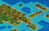
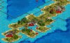
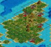
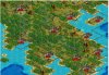
i did some more work yesterday, pretty much finishing off the dutch indies. so i move south from there and head to australia which leads to a few issues to resolve going forward.

primary issue is how to represent the US in Australia? the northeast part of the continent was loaded with american personnel and equipment. the easiest option imo is to give the yanks a city or two in that northeastern corner, cairns perhaps and maybe townsville? they were major US bases and the first push against the japanese was conducted from here (against targets in the solomans iirc).

i am always hesitant to soil the geographical integrity of a continent by placing cities from far away civs on it. but australia may be an exception here...since history says that part was used by US forces and the fact that the continent is so damn big (on the biq file). iow, there is a lot of room on this map to place a few USA cities down under and preserve australian integrity.

another issue i've been grappling with is the fact the McArthur was commander of all forces in the sw pacific. this included australian forces that were under his charge. i read that McArthur wouldn't allow US forces to be led by Australian officers. fair enough. so this lends to the question: should Australia be rolled into the US position? i am leaning towards not doing this for obvious reasons. i think the few US cities on the continent down there will suffice. thoughts?

another option for those that wish to see more civs instead of less is to split apart the commonwealth civs and make each one its own. so it would be Australia, NZ, British India, Canada. not sure i want to go this route but thought i'd put it out there. comments appreciated :)
 
As much as I think it would be an interesting idea to break the Empire up into its individual countries it would be difficult to do so. Also some commonwealth sent very little to the Pacific for example the Pacific War for Canada was very much a minor theatre for the Canadians. After we lost 2000 of our troops at Hong Kong. The Prime Minister of Canada declared that only volunteers would be sent to the Pacific. We also had HMCS Uganda vote itself out of the pacific with her crew with 600 of the 900 voting against serving in that war.

So if you were to have Canada as an individual nation in your scenario it would be very difficult to mimic that aspect of Canadian history and for a person to win the war playing Canada. However, it would be a very interesting idea to try!
 
agreed that Canada's role was really limited. and that is part of the problem in separating each commonwealth nation. on the flipside of this though, Australia had a distinct role in the war as did the commonwealth forces in India. so it's at least plausible to consider splitting. but i am probably not gonna do it ;)

anyone have suggestions for gfx for the Great Barrier Reef? i searched a little but couldn't pinpoint anything specific. thinking LM Sea terrain if possible.
 
Everything looks great so far, personally I find city placements the most enjoyable part of scenario creation.

I also don't see separating the Commonwealth as that viable, but some advantages it would bring are that historically at this time Canada, Australia, etc.were mostly independent anyways. It would also be much easier to choose which units get made where(i.e Indian infantry, Aussie) without having to put trade barriers everwhere.
 
trade barriers aren't an issue. the land masses are separated already. so isolating commonwealth builds is easy with the no water/air trade. there could be some small quirks with some unit and/or building builds. but nothing i could not get around (as mentioned :)). separating them (mainly aussie and india) could allow for some more dynamic layers. but i'm not so concerned about layers quite yet. perhaps the single best reason to separate india and australia : the city gfx

i want to see if i can find a place for the Dutch, perhaps some type of colonial govt in exile (or something like that). do not want to get too exotic with it though. will look into it today :D
 
Splitting up a monolithic 'Commonwealth' would be a good move, with Australia + NZ, British + India and Canada being the three 'successor states', if you like.

Representing the US presence in Australia could be done using invisible US cities as bases.

Setting up tech triggers for the construction/entry into play of the British Pacific Fleet would provide some interesting dynamics.

Depending on the end point of the scenario, there is scope for some of the cancelled units/postwar developments such as the Midways and Audacious CVs and various cruisers for the RN, USN and IJN. Further consideration could be given to the Montanas and Super Yamatos.
 
thanks for the remarks, old buddy. glad to see you still check in :)

atm, i am leaning towards splitting up the commonwealth countries (but keeping them all aligned of course). it will solve a handful of small issues imo and sort of relegate each commonwealth country to their respective theater. iow, being split up will, i think, let the AI concentrate more on their areas. now, i am sort of new to the pacific theater and i am surely learning stuff as i go along. so bear with me on all this :)

i did some more work on the map over the last few days, particularly Australia. i added in a few cities for them and i also added the US into Queensland (northeast australia). i gave the americans 4 cities: cairns, townsville, rockhampton, and brisbane. it's a little clunky, i'll admit. but there is no map 'squishing' where US cities on the australian continent are butting up against aussie cities. so that part is not a problem. but it just seems a little weird atm. i'll post a screen of the continent in due time. all told, i think australia has 15 cities + or -. some are isolated while the ones in New South Wales (se australia for those not familiar) are blocked together. final step for the map and australia: get the resources right. i have some in there based on some research i did thus far. but need to put in finishing touches.

hopefully, i will take the scenario past 1945 and probably introduce some of the what-if's. so montanas, super yamotaos and the like will probably be in play :D and yes to RN projections into the pacific.
 
Top Bottom