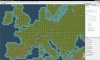
This is somewhat inspired by the Road to War mod for CIV 4: BTS. So far it's just an early map (I've uploaded a screenshot of part of it). I'm posing this to see what sort of interest there is.
This map will include Europe as far north as Lapland and as far east as a line drawn through the middle of the Caspian Sea, and as far south as a line drawn through the top of the Persian Gulf. It will also include substantial parts of the eastern seaboard of North America, probably as far west as the Great Lakes somewhere.
I'm making the map as realistic as possible, to the point of making it to scale with an actual map -- I divided the map into a grid and divided World-Builder into a same scale grid and then painted each square in by eye. It's going to include geographically correct rivers as well (Meuse, Vistula, Don, Volga, etc). There will be some improvements from the RTW map, such as the Crimean Penninsula actually being a penninsula (no overland route straight from Sevastapol to Rostov enclosing the Sea of Azov)
You can see mountains and hills and rivers. I plan to add forest and marshes later (the Ardennes, and the Pripet Marshes will be included.)
Some things I'd like to do: Smaller countries I'd like to represent with city-states. For example, all three of the Low Countries, Denmark (Room for 2 Danish cities on the map, though), Switzerland, Albania, and all three of the Baltic States. Maybe Ireland as well. This requires adding (or renaming) city-states to the actual country names.
Anyway, thoughts? I will probably update this thread as I continue working.
")