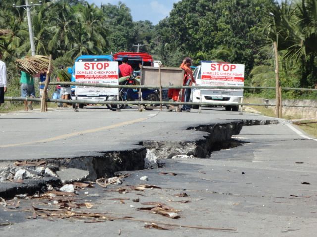
7.2 Carmen Bohol

7 richter scale earthquakes indeed are quite threatening. If the buildings in the area hit were not designed with large earthquakes taken into account then many will collapse. The last major earthquake in my own city was around 7 richter as well (just checked, it was 6.6, not very surprisingly), although (afaik) only one building collapsed, an apartment building, and there even had been a trial of the civil engineer on account of supposedly not following the laws regarding quake-protection.

Strange things happen after such horrors. For example, i was born later on that year ;)
 
7 richter scale earthquakes indeed are quite threatening.
Yes, they are. Someone has already mentioned the Loma Prieta earthquake, which was magnitude 6.9

Although its epicenter was 60 miles from San Francisco, CA it still did major damage in that city, including collapsing a freeway and the bridge which crosses the bay to Oakland.

The freeway collapse alone killed 42 people.
 

Attachments

  • LomaPrietaCypressViaductSanFrancisco.jpg
    LomaPrietaCypressViaductSanFrancisco.jpg
    70.2 KB · Views: 39
I used a program I saw in the Polish WWII thread called 'distance as the bird flies' or some such and between where I am and Sagbayan where the epicenter was is less than 25 miles, not 35 as I originally estimated. Here's the aftershock record as it now stands starting with the original quake.

http://www.phivolcs.dost.gov.ph/html/update_SOEPD/EQLatest.html

Description: Description: Description: C:\Programming\EQP\ISSOP\EQP9-14\Internet\EarthquakeBanner.jpg
PHIVOLCS Earthquake Bulletins of latest seismic events in the Philippines are listed below. The event parameters (hypocenter, time and magnitude) are determined using incoming data from the Philippine National Seismic Network
Philippine Standard Time (PST) is eight hours ahead of Coordinated Universal Time (UTC). (PST = UTC + 8H) UTC is the time standard for which the world regulates clocks and time.
Earthquakes in this list with their date and time underlined in blue have reported felt intensities. Intensity ratings are based on the PHIVOLCS Earthquake Intensity Scale(km)


Date - Time Latitude Longitude Depth Magnitude Location
(Philippine Time) (ºN) (ºE)
18 Oct 2013 - 04:54 PM 09.76 123.90 003 4.6 014 km N 22° E of Tagbilaran City
18 Oct 2013 - 04:48 PM 09.81 123.98 001 4.7 023 km N 37° E of Tagbilaran City
18 Oct 2013 - 02:38 PM 09.92 124.01 005 3.0 035 km N 30° E of Tagbilaran City
18 Oct 2013 - 12:56 PM 16.72 122.12 020 4.0 027 km N 35° W of Dinapigue (Isabela)
18 Oct 2013 - 10:40 AM 09.74 123.70 027 2.9 020 km N 59° W of Tagbilaran City
18 Oct 2013 - 09:49 AM 09.88 123.85 031 2.5 026 km N 2° W of Tagbilaran City
18 Oct 2013 - 08:33 AM 09.71 123.62 004 4.9 027 km N 74° W of Tagbilaran City
18 Oct 2013 - 06:53 AM 09.86 123.79 001 3.4 025 km N 17° W of Tagbilaran City
18 Oct 2013 - 05:25 AM 09.68 123.60 001 3.8 029 km N 82° E of Tagbilaran City
18 Oct 2013 - 05:09 AM 09.91 124.07 019 2.4 038 km N 38° E of Tagbilaran City
18 Oct 2013 - 04:39 AM 09.78 123.95 014 3.6 019 km N 34° E of Tagbilaran City
18 Oct 2013 - 04:33 AM 09.78 125.42 036 3.2 009 km N 22° W of Sulat (Eastern Samar)
18 Oct 2013 - 04:04 AM 11.67 124.29 026 3.0 007 km S 82° W of Kawayan (Biliran)
18 Oct 2013 - 03:58 AM 09.87 123.98 009 2.5 029 km N 30° E of Tagbilaran City
18 Oct 2013 - 03:43 AM 09.80 123.93 007 2.7 021 km N 24° E of Tagbilaran City
18 Oct 2013 - 03:30 AM 12.45 124.60 096 3.6 007 km S 37° W of Catarman (Northern Samar)
18 Oct 2013 - 03:06 AM 09.87 124.05 001 3.6 033 km N 40° E of Tagbilaran City
18 Oct 2013 - 02:48 AM 09.99 124.18 001 3.3 053 km N 42° E of Tagbilaran City
18 Oct 2013 - 02:39 AM 09.78 124.11 019 3.0 032 km N 63° E of Tagbilaran City
18 Oct 2013 - 01:59 AM 09.77 123.92 022 2.6 016 km N 27° E of Tagbilaran City
18 Oct 2013 - 12:57 AM 09.81 123.97 018 2.9 040 km N 40° E of Tagbilaran City
18 Oct 2013 - 12:24 AM 09.97 124.13 019 2.9 048 km N 40° E of Tagbilaran City
18 Oct 2013 - 12:17 AM 09.94 123.98 001 3.3 036 km N 22° E of Tagbilaran City
18 Oct 2013 - 12:13 AM 09.97 124.22 022 3.4 054 km N 48° E of Tagbilaran City
18 Oct 2013 - 12:04 AM 09.97 124.31 018 3.5 062 km N 55° E of Tagbilaran City
17 Oct 2013 - 11:11 PM 09.64 123.83 007 3.4 003 km S 72° W of Tagbilaran City
17 Oct 2013 - 11:09 PM 10.02 124.23 022 3.1 059 km N 44° E of Tagbilaran City
17 Oct 2013 - 10:44 PM 09.81 123.80 019 3.3 019 km N 18° W of Tagbilaran City
17 Oct 2013 - 10:27 PM 09.86 124.28 037 2.7 053 km N 63° E of Tagbilaran City
17 Oct 2013 - 09:56 PM 09.63 123.58 001 3.4 031 km S 86° E of Tagbilaran City
17 Oct 2013 - 07:55 PM 09.97 124.15 003 3.2 049 km N 42° E of Tagbilaran City
17 Oct 2013 - 06:39 PM 11.49 122.02 022 2.5 007 km N 29° W of Culasi (Antique)
17 Oct 2013 - 05:49 PM 09.93 124.07 001 2.5 040 km N 36° E of Tagbilaran City
17 Oct 2013 - 04:27 PM 09.68 124.15 024 2.3 033 km N 82° E of Tagbilaran City
17 Oct 2013 - 02:35 PM 09.75 124.12 024 2.9 032 km N 68° E of Tagbilaran City
17 Oct 2013 - 01:46 PM 09.91 124.27 005 4.5 055 km N 58° E of Tagbilaran City
17 Oct 2013 - 01:38 PM 09.73 123.65 010 4.0 025 km N 66° W of Tagbilaran City
17 Oct 2013 - 12:37 PM 09.76 123.81 016 2.9 014 km N 22° W of Tagbilaran City
17 Oct 2013 - 11:36 AM 09.81 124.37 007 4.6 061 km N 72° W of Tagbilaran City
17 Oct 2013 - 11:29 AM 09.83 124.35 006 4.6 058 km N 70° E of Tagbilaran City
17 Oct 2013 - 07:37 AM 09.78 123.77 001 5.5 018 km N 31° W of Tagbilaran City
17 Oct 2013 - 06:19 AM 09.90 124.02 005 4.4 034 km N 32° E of Tagbilaran City
17 Oct 2013 - 05:27 AM 09.81 123.67 019 2.6 027 km N 49° W of Tagbilaran City
17 Oct 2013 - 03:56 AM 10.06 124.18 009 3.4 058 km N 38° E of Tagbilaran City
17 Oct 2013 - 02:57 AM 09.78 123.55 005 3.8 037 km N 66° W of Tagbilaran City
17 Oct 2013 - 01:04 AM 09.89 124.01 005 4.6 032 km N 32° E of Tagbilaran City
16 Oct 2013 - 11:35 PM 09.78 123.55 020 3.5 037 km N 66° W of Tagbilaran City
16 Oct 2013 - 11:32 PM 09.58 123.94 010 3.5 012 km S 51° E of Tagbilaran City
16 Oct 2013 - 11:08 PM 09.65 123.61 023 4.8 027 km N 89° W of Tagbilaran City
16 Oct 2013 - 09:17 PM 09.76 123.56 016 3.5 035 km N 68° W of Tagbilaran City
16 Oct 2013 - 08:12 PM 09.52 123.98 016 2.0 019 km S 45° E of Tagbilaran City
16 Oct 2013 - 08:01 PM 09.96 124.23 016 3.1 054 km N 50° E of Tagbilaran City
16 Oct 2013 - 07:08 PM 09.65 123.62 003 3.3 026 km N 88° W of Tagbilaran City
16 Oct 2013 - 06:15 PM 10.03 124.12 014 3.8 052 km N 34° E of Tagbilaran City
16 Oct 2013 - 05:56 PM 09.92 124.02 001 4.0 035 km N 31° E of Tagbilaran City
16 Oct 2013 - 05:18 PM 09.71 123.60 005 2.8 029 km N 76° W of Tagbilaran City
16 Oct 2013 - 04:46 PM 09.97 124.24 017 3.1 056 km N 49° E of Tagbilaran City
16 Oct 2013 - 04:20 PM 09.82 124.03 007 3.6 027 km N 45° E of Tagbilaran City
16 Oct 2013 - 03:36 PM 09.68 123.61 019 3.6 028 km N 82° W of Tagbilaran City
16 Oct 2013 - 03:31 PM 09.67 123.59 001 4.2 030 km N 83° W of Tagbilaran City
16 Oct 2013 - 03:17 PM 09.66 123.62 003 3.9 026 km N 87° W of Tagbilaran City
16 Oct 2013 - 03:11 PM 09.72 123.58 009 3.0 031 km N 74° W of Tagbilaran City
16 Oct 2013 - 02:41 PM 09.63 123.53 001 3.8 036 km S 87° W of Tagbilaran City
16 Oct 2013 - 02:33 PM 09.93 124.15 013 4.5 045 km N 46° E of Tagbilaran City
16 Oct 2013 - 01:33 PM 09.70 123.61 001 4.3 028 km N 77° W of Tagbilaran City
16 Oct 2013 - 01:28 PM 10.04 124.20 016 4.4 058 km N 41° E of Tagbilaran City
16 Oct 2013 - 12:36 PM 10.05 124.12 001 2.8 053 km N 33° E of Tagbilaran City
16 Oct 2013 - 12:23 PM 09.84 123.95 001 4.0 024 km N 25° E of Tagbilaran City
16 Oct 2013 - 12:11 PM 09.94 124.26 003 2.6 055 km N 54° E of Tagbilaran City
16 Oct 2013 - 11:04 AM 09.94 124.30 008 3.5 058 km N 56° E of Tagbilaran City
16 Oct 2013 - 10:42 AM 09.93 124.29 012 5.1 057 km N 56° E of Tagbilaran City
16 Oct 2013 - 09:36 AM 09.75 123.56 010 5.1 034 km N 70° W of Tagbilaran City
16 Oct 2013 - 09:12 AM 09.89 123.91 001 2.6 027 km N 12° E of Tagbilaran City
16 Oct 2013 - 08:45 AM 09.96 123.95 032 3.3 037 km N 17° E of Tagbilaran City
16 Oct 2013 - 08:28 AM 09.81 123.89 002 2.6 019 km N 12° E of Tagbilaran City
16 Oct 2013 - 07:50 AM 09.95 124.11 001 3.2 044 km N 39° E of Tagbilaran City
16 Oct 2013 - 06:51 AM 10.02 124.14 010 3.7 052 km N 37° E of Tagbilaran City
16 Oct 2013 - 06:05 AM 09.94 123.96 007 2.9 035 km N 20° E of Tagbilaran City
16 Oct 2013 - 05:44 AM 09.89 124.01 010 3.8 032 km N 32° E of Tagbilaran City
16 Oct 2013 - 04:53 AM 09.95 124.12 006 3.4 045 km N 40° E of Tagbilaran City
16 Oct 2013 - 04:45 AM 10.05 124.15 003 3.8 056 km N 37° E of Tagbilaran City
16 Oct 2013 - 04:34 AM 10.01 124.13 002 3.8 051 km N 37° E of Tagbilaran City
16 Oct 2013 - 04:00 AM 09.80 124.31 023 3.3 053 km N 71° E of Tagbilaran City
16 Oct 2013 - 03:53 AM 09.84 123.86 005 3.7 022 km N 0° E of Tagbilaran City
16 Oct 2013 - 03:47 AM 09.68 123.60 006 4.1 028 km N 81° W of Tagbilaran City
16 Oct 2013 - 03:30 AM 10.03 124.20 005 4.3 058 km N 42° E of Tagbilaran City
16 Oct 2013 - 03:04 AM 09.91 124.02 006 3.8 035 km N 31° E of Tagbilaran City
16 Oct 2013 - 02:23 AM 10.03 124.14 003 2.2 053 km N 37° E of Tagbilaran City
16 Oct 2013 - 02:21 AM 09.66 123.60 009 3.1 029 km N 86° W of Tagbilaran City
16 Oct 2013 - 02:08 AM 09.96 123.96 004 3.0 037 km N 18° E of Tagbilaran City
16 Oct 2013 - 02:02 AM 09.95 124.19 004 3.8 050 km N 47° E of Tagbilaran City
16 Oct 2013 - 01:40 AM 09.77 123.93 005 3.8 017 km N 31° E of Tagbilaran City
16 Oct 2013 - 01:32 AM 10.01 124.18 009 4.8 054 km N 41° E of Tagbilaran City
16 Oct 2013 - 12:57 AM 09.95 124.07 001 4.6 041 km N 35° E of Tagbilaran City
16 Oct 2013 - 12:44 AM 09.95 124.21 004 4.3 052 km N 50° E of Tagbilaran City
16 Oct 2013 - 12:19 AM 09.98 124.17 002 3.6 051 km N 43° E of Tagbilaran City
16 Oct 2013 - 12:05 AM 10.02 124.15 007 4.5 053 km N 38° E of Tagbilaran City
15 Oct 2013 - 11:42 PM 09.96 124.21 003 4.3 053 km N 49° E of Tagbilaran City
15 Oct 2013 - 11:24 PM 09.92 124.11 005 3.3 042 km N 43° E of Tagbilaran City
15 Oct 2013 - 11:08 PM 09.85 123.92 072 3.8 024 km N 17° E of Tagbilaran City
15 Oct 2013 - 11:03 PM 09.97 124.30 018 3.7 061 km N 53° E of Tagbilaran City
15 Oct 2013 - 10:59 PM 09.75 123.54 001 3.2 036 km N 72° W of Tagbilaran City
15 Oct 2013 - 10:14 PM 09.86 124.19 015 4.3 044 km N 57° E of Tagbilaran City
15 Oct 2013 - 10:10 PM 09.79 123.70 001 2.7 023 km N 48° W of Tagbilaran City
15 Oct 2013 - 09:51 PM 09.72 123.66 005 4.8 024 km N 69° W of Tagbilaran City
15 Oct 2013 - 08:31 PM 10.05 124.13 003 3.5 054 km N 34° E of Tagbilaran City
15 Oct 2013 - 08:26 PM 10.00 124.28 020 4.2 062 km N 50° E of Tagbilaran City
15 Oct 2013 - 08:19 PM 09.73 123.64 011 3.9 026 km N 67° W of Tagbilaran City
15 Oct 2013 - 06:49 PM 09.79 123.87 005 4.2 016 km N 5° E of Tagbilaran City
15 Oct 2013 - 06:07 PM 10.03 124.21 010 3.5 057 km N 42° E of Tagbilaran City
15 Oct 2013 - 05:47 PM 09.92 124.17 009 3.6 046 km N 49° E of Tagbilaran City
15 Oct 2013 - 05:18 PM 09.88 124.05 019 3.9 034 km N 38° E of Tagbilaran City
15 Oct 2013 - 04:52 PM 09.86 124.02 009 3.9 030 km N 38° E of Tagbilaran City
15 Oct 2013 - 04:42 PM 09.79 123.69 004 4.5 024 km N 48° W of Tagbilaran City
15 Oct 2013 - 04:36 PM 10.00 124.23 043 4.7 047 km N 47° E of Tagbilaran City
15 Oct 2013 - 04:33 PM 09.97 124.16 006 3.5 049 km N 43° E of Tagbilaran City
15 Oct 2013 - 04:23 PM 09.90 124.10 007 3.5 040 km N 44° E of Tagbilaran City
15 Oct 2013 - 04:09 PM 09.86 124.27 019 3.4 051 km N 62° E of Tagbilaran City
15 Oct 2013 - 03:59 PM 09.78 123.83 005 3.4 016 km N 13° W of Tagbilaran City
15 Oct 2013 - 03:16 PM 09.77 123.16 001 2.7 029 km N 61° W of Tagbilaran City
15 Oct 2013 - 02:52 PM 17.94 121.18 017 2.2 009 km S 03° W of Kabugao (Apayao)
15 Oct 2013 - 02:43 PM 09.68 123.65 007 3.4 025 km N 58° W of Tagbilaran City
15 Oct 2013 - 02:29 PM 10.01 124.21 016 3.5 056 km N 44° E of Tagbilaran City
15 Oct 2013 - 01:56 PM 09.88 124.11 022 3.8 038 km N 47° E of Tagbilaran City
15 Oct 2013 - 01:12 PM 09.78 123.87 005 4.2 015 km N 6° E of Tagbilaran City
15 Oct 2013 - 12:36 AM 09.84 123.91 008 4.5 023 km N 16° E of Tagbilaran City
15 Oct 2013 - 12:22 PM 09.93 124.10 053 4.8 021 km N 20° E of Tagbilaran City
15 Oct 2013 - 11:42 AM 09.71 123.80 001 3.1 009 km N 40° W of Tagbilaran City
15 Oct 2013 - 11:39 AM 09.83 123.95 001 3.0 022 km N 26° E of Tagbilaran City
15 Oct 2013 - 11:34 AM 09.84 123.88 001 3.9 022 km N 8° E of Tagbilaran City
15 Oct 2013 - 11:29 AM 09.82 123.92 017 2.9 021 km N 20° E of Tagbilaran City
15 Oct 2013 - 11:22 AM 10.03 124.16 008 2.9 055 km N 38° E of Tagbilaran City
15 Oct 2013 - 11:19 AM 09.91 124.07 010 3.1 038 km N 38° E of Tagbilaran City
15 Oct 2013 - 11:05 AM 09.90 124.10 021 2.8 013 km N 51° W of Carmen (Bohol)
15 Oct 2013 - 11:00 AM 09.79 123.98 015 3.1 021 km N 40° E of Tagbilaran City
15 Oct 2013 - 10:42 AM 09.85 124.03 016 4.2 030 km N 39° E of Tagbilaran City
15 Oct 2013 - 10:36 AM 09.91 124.03 003 3.9 035 km N 33° E of Tagbilaran City
15 Oct 2013 - 10:31 AM 09.81 123.99 029 3.2 023 km N 40° E of Tagbilaran City
15 Oct 2013 - 09:55 AM 09.88 123.89 020 4.5 026 km N 8° E of Tagbilaran City
15 Oct 2013 - 09:37 AM 10.01 124.21 016 4.3 021 km N 6° E of Carmen (Bohol)
15 Oct 2013 - 09:30 AM 09.84 124.03 007 3.7 002 km S 53° E of Catigbian (Bohol)
15 Oct 2013 - 09:07 AM 09.99 124.25 018 3.7 020 km N 19° W of Carmen (Bohol)
15 Oct 2013 - 08:28 AM 09.91 124.14 023 3.4 011 km N 32° W of Carmen (Bohol)
15 Oct 2013 - 08:12 AM 09.86 124.07 012 7.2 006 km S 24° W of Sagbayan (Borja) (Bohol)
 
Here's the aftershock record as it now stands starting with the original quake
Scanning through the list, I see several which are magnitude 4+ and a few which are 5+. After such a major quake, the aftershocks are frightening. And the bigger ones can cause buildings which are weakened by the main quake to finally collapse or the debris to shift, endangering even more lives.

The last I heard, the death toll was approaching 200. I feel sorrow for Filipinos who have lost loved ones, or had their homes destroyed, or their livelihoods taken... or all three.

Such random devastation to the lives of innocent people. They woke up that morning, everything normal. But by 8:30 a.m., and from out of the blue, their lives were horribly changed, perhaps forever.
 
Yes, that's right householder. In a moment, from peace, the world went to chaos. Some people may never recover.
 
CivLancer, after the devastating 2010 earthquake in Haiti, there was concern about the weather, and how storms would complicate recovery efforts and generally make life miserable for the survivors.

What is the climate like in Bohol? Do tropical storms still occur this late in the year? I know Luzon was hit by Typhoon Nari/Santi a few days ago, and it caused significant harm.
 
its been a while since I lived in quake country, but I dont remember nearly that many aftershocks after a quake. Course the bigger ones leave a lasting impression


You sure that aint near a volcano?

I hope y'all aint near a coast with the epicenter within sight
 
householder, its tropical. Living outdoors is not a problem except when it rains and there are many folks sleeping on the ground now. An amigo of mine in Pennsylvania is sending $100 (we're going to equal it, so $200) to a guy who lost his daughter and her baby in the quake and who is sleeping on the ground as his house landed on them. Another friend who is the woman's brother is at the funeral and we texted him the news and he told the father who was crying that someone would help him. Guy needed to catch a break. Thing is, all the houses on the block are down. Beyond that, I don't know.

The quake left little damage here at my place, so its time to give back. We also donated 50 kilos of rice and some canned food. I feel so blessed when I look at my family, the house, its like we dodged a bullet and I'm grateful.

Luzon has much worse weather than Bohol which has very few typhoons.

Berzerker, the aftershock numbers amaze me too and something does seem wrong, but there are no volcanoes on the island as its a limestone island. I hope it never has a volcano pop out somewhere!
 
Berzerker, I know nothing about earthquakes other than what I read in the news, but the experts are saying that this quake (and aftershocks) are the result of slippage along the East Bohol Fault.

The likely culprit is the East Bohol Fault, [Renato Solidum, director of the Philippine Institute of Volcanology and Seismology] said.

The East Bohol Fault, which crosses southern Bohol Island, helps relieve some of the tectonic pressure on the Philippines. The islands are crumpling between three crashing tectonic plates: the Philippine, Sunda and Eurasia plates.

Though the East Bohol Fault isn't along one of the colliding plate boundaries, it is a reverse fault. When the fault breaks, the earth on either side of the fracture moves closer together, one block sliding up on top of the other. This compression takes up some of the constant squeezing.
http://www.livescience.com/40432-what-caused-bohol-philippine-earthquake.html
 
I don't get it. The aftershocks are back with their original strength. Just today we've had lots of 4s and even a couple of 5s. Shouldn't these things be becoming less and not stronger?

Date - Time Latitude Longitude Depth Magnitude Location
(Philippine Time) (ºN) (ºE)

20 Oct 2013 - 02:23 PM 10.08 124.27 018 4.1 067 km N 43° E of Tagbilaran City
20 Oct 2013 - 11:16 AM 09.87 123.89 016 2.4 026 km N 09° E of Tagbilaran City
20 Oct 2013 - 09:45 AM 09.91 124.02 003 5.0 035 km N 32° E of Tagbilaran City
20 Oct 2013 - 08:11 AM 10.07 124.22 012 3.3 062 km N 40° E of Tagbilaran City
20 Oct 2013 - 06:53 AM 10.03 124.23 007 3.9 060 km N 44° E of Tagbilaran City
20 Oct 2013 - 06:38 AM 09.92 124.02 006 4.0 036 km N 31° E of Tagbilaran City
20 Oct 2013 - 05:43 AM 10.02 124.17 008 4.3 054 km N 40° E of Tagbilaran City
20 Oct 2013 - 05:29 AM 10.04 124.10 001 4.2 052 km N 32° E of Tagbilaran City
20 Oct 2013 - 05:11 AM 09.64 123.61 001 4.2 027 km N 90° W of Tagbilaran City
20 Oct 2013 - 04:40 AM 10.03 124.24 005 5.1 060 km N 44° E of Tagbilaran City
20 Oct 2013 - 03:49 AM 13.58 120.76 150 1.9 014 km N 12° E of Abra de Ilog (Occidental Mindoro)
20 Oct 2013 - 03:29 AM 09.92 124.30 003 3.3 059 km N 58° E of Tagbilaran City
20 Oct 2013 - 02:08 AM 10.06 124.21 005 3.9 061 km N 40° E of Tagbilaran City
20 Oct 2013 - 01:52 AM 10.04 124.22 006 3.6 060 km N 42° E of Tagbilaran City
20 Oct 2013 - 12:44 AM 14.01 120.54 188 2.2 021 km S 72° W of Lian (Batangas)
19 Oct 2013 - 11:55 PM 09.78 123.64 010 3.1 028 km N 58° W of Tagbilaran City
19 Oct 2013 - 11:52 PM 10.04 124.23 011 3.0 060 km N 43° E of Tagbilaran City
19 Oct 2013 - 11:45 PM 09.90 123.71 001 2.5 033 km N 30° W of Tagbilaran City
19 Oct 2013 - 11:35 PM 09.88 123.79 016 3.4 027 km N 15° W of Tagbilaran City
19 Oct 2013 - 10:48 PM 09.86 124.07 015 3.4 034 km N 45° E of Tagbilaran City
19 Oct 2013 - 10:23 PM 09.66 123.62 001 3.7 026 km N 67° W of Tagbilaran City
19 Oct 2013 - 09:48 PM 09.79 123.66 021 2.5 027 km N 53° W of Tagbilaran City
19 Oct 2013 - 08:23 PM 10.06 126.38 023 3.2 034 km N 82° E of Burgos (Surigao del Norte)
19 Oct 2013 - 08:20 PM 09.95 124.20 015 2.3 051 km N 49° E of Tagbilaran City
19 Oct 2013 - 08:12 PM 06.52 126.76 017 3.4 068 km S 30° E of Tarragona (Davao Oriental)
19 Oct 2013 - 07:40 PM 09.92 124.20 028 2.6 050 km N 51° E of Tagbilaran City
19 Oct 2013 - 07:19 PM 09.87 124.05 006 3.3 033 km N 40° E of Tagbilaran City
19 Oct 2013 - 07:09 PM 10.10 124.15 005 3.3 060 km N 32° E of Tagbilaran City
19 Oct 2013 - 07:00 PM 09.76 123.72 009 2.9 019 km N 50° W of Tagbilaran City
19 Oct 2013 - 05:26 PM 09.82 123.77 017 3.1 022 km N 24° W of Tagbilaran City
19 Oct 2013 - 02:55 PM 10:03 124.23 015 2.6 059 km N 44° E of Tagbilaran City
19 Oct 2013 - 01:24 PM 09.81 123.96 007 3.9 022 km N 34° E of Tagbilaran City
19 Oct 2013 - 10:50 AM 09.91 124.11 005 2.8 040 km N 44° E of Tagbilaran City
19 Oct 2013 - 10:15 AM 09.77 124.01 020 2.1 022 km N 52° E of Tagbilaran City
19 Oct 2013 - 09:39 AM 09.67 123.52 012 2.1 037 km N 86° W of Tagbilaran City
19 Oct 2013 - 08:51 AM 09.80 123.92 014 3.3 019 km N 23° E of Tagbilaran City
19 Oct 2013 - 07:51 AM 09.70 123.58 007 2.4 031 km N 79° W of Tagbilaran City
19 Oct 2013 - 06:45 AM 09.78 123.63 002 2.8 029 km N 58° W of Tagbilaran City
19 Oct 2013 - 03:23 AM 09.69 124.11 061 2.9 028 km N 79° E of Tagbilaran City
19 Oct 2013 - 02:55 AM 09.96 124.07 001 3.7 042 km N 35° E of Tagbilaran City
19 Oct 2013 - 02:54 AM 19.70 121.19 008 3.8 055 km N 32° W of Calayan Cagayan
19 Oct 2013 - 02:46 AM 09.83 123.98 001 3.5 025 km N 33° E of Tagbilaran City
19 Oct 2013 - 01:31 AM 09.99 124.07 009 3.5 045 km N 31° E of Tagbilaran City
19 Oct 2013 - 01:08 AM 09.63 123.61 001 4.2 027 km S 86° W of Tagbilaran City
19 Oct 2013 - 01:03 AM 09.66 123.62 007 1.7 026 km N 87° W of Tagbilaran City
19 Oct 2013 - 12:46 AM 09.65 123.93 026 2.0 008 km N 85° E of Tagbilaran City
18 Oct 2013 - 11:01 PM 09.87 124.02 024 2.6 031 km N 37° E of Tagbilaran City
18 Oct 2013 - 10:58 PM 09.87 124.05 004 2.4 033 km N 40° E of Tagbilaran City
18 Oct 2013 - 10:43 PM 09.79 123.89 020 2.7 017 km N 12° E of Tagbilaran City
18 Oct 2013 - 09:57 PM 09.65 123.61 001 2.0 027 km N 88° W of Tagbilaran City
18 Oct 2013 - 09:40 PM 06.65 126.58 020 3.7 047 km S 18° E of Tarragona (Davao Oriental)
18 Oct 2013 - 09:22 PM 09.59 123.62 001 4.6 027 km S 78° W of Tagbilaran City
18 Oct 2013 - 09:12 PM 09.89 124.10 001 2.3 039 km N 44° E of Tagbilaran City
18 Oct 2013 - 09:03 PM 09.91 123.81 001 2.4 029 km N 11° W of Tagbilaran City
18 Oct 2013 - 08:58 PM 10.02 124.23 010 3.0 058 km N 45° E of Tagbilaran City
18 Oct 2013 - 08:47 PM 09.87 123.76 003 2.1 027 km N 22° W of Tagbilaran City
18 Oct 2013 - 04:54 PM 09.76 123.90 003 4.6 014 km N 22° E of Tagbilaran City
18 Oct 2013 - 04:48 PM 09.81 123.98 001 4.7 023 km N 37° E of Tagbilaran City
18 Oct 2013 - 02:38 PM 09.92 124.01 005 3.0 035 km N 30° E of Tagbilaran City
18 Oct 2013 - 12:56 PM 16.72 122.12 020 4.0 027 km N 35° W of Dinapigue (Isabela)
18 Oct 2013 - 10:40 AM 09.74 123.70 027 2.9 020 km N 59° W of Tagbilaran City
18 Oct 2013 - 09:49 AM 09.88 123.85 031 2.5 026 km N 2° W of Tagbilaran City
18 Oct 2013 - 08:33 AM 09.71 123.62 004 4.9 027 km N 74° W of Tagbilaran City
18 Oct 2013 - 06:53 AM 09.86 123.79 001 3.4 025 km N 17° W of Tagbilaran City
18 Oct 2013 - 05:25 AM 09.68 123.60 001 3.8 029 km N 82° E of Tagbilaran City
18 Oct 2013 - 05:09 AM 09.91 124.07 019 2.4 038 km N 38° E of Tagbilaran City
18 Oct 2013 - 04:39 AM 09.78 123.95 014 3.6 019 km N 34° E of Tagbilaran City
18 Oct 2013 - 04:33 AM 09.78 125.42 036 3.2 009 km N 22° W of Sulat (Eastern Samar)
18 Oct 2013 - 04:04 AM 11.67 124.29 026 3.0 007 km S 82° W of Kawayan (Biliran)
18 Oct 2013 - 03:58 AM 09.87 123.98 009 2.5 029 km N 30° E of Tagbilaran City
18 Oct 2013 - 03:43 AM 09.80 123.93 007 2.7 021 km N 24° E of Tagbilaran City
18 Oct 2013 - 03:30 AM 12.45 124.60 096 3.6 007 km S 37° W of Catarman (Northern Samar)
18 Oct 2013 - 03:06 AM 09.87 124.05 001 3.6 033 km N 40° E of Tagbilaran City
18 Oct 2013 - 02:48 AM 09.99 124.18 001 3.3 053 km N 42° E of Tagbilaran City
18 Oct 2013 - 02:39 AM 09.78 124.11 019 3.0 032 km N 63° E of Tagbilaran City
18 Oct 2013 - 01:59 AM 09.77 123.92 022 2.6 016 km N 27° E of Tagbilaran City
18 Oct 2013 - 12:57 AM 09.81 123.97 018 2.9 040 km N 40° E of Tagbilaran City
18 Oct 2013 - 12:24 AM 09.97 124.13 019 2.9 048 km N 40° E of Tagbilaran City
18 Oct 2013 - 12:17 AM 09.94 123.98 001 3.3 036 km N 22° E of Tagbilaran City
18 Oct 2013 - 12:13 AM 09.97 124.22 022 3.4 054 km N 48° E of Tagbilaran City
18 Oct 2013 - 12:04 AM 09.97 124.31 018 3.5 062 km N 55° E of Tagbilaran City
17 Oct 2013 - 11:11 PM 09.64 123.83 007 3.4 003 km S 72° W of Tagbilaran City
17 Oct 2013 - 11:09 PM 10.02 124.23 022 3.1 059 km N 44° E of Tagbilaran City
17 Oct 2013 - 10:44 PM 09.81 123.80 019 3.3 019 km N 18° W of Tagbilaran City
17 Oct 2013 - 10:27 PM 09.86 124.28 037 2.7 053 km N 63° E of Tagbilaran City
17 Oct 2013 - 09:56 PM 09.63 123.58 001 3.4 031 km S 86° E of Tagbilaran City
17 Oct 2013 - 07:55 PM 09.97 124.15 003 3.2 049 km N 42° E of Tagbilaran City
17 Oct 2013 - 06:39 PM 11.49 122.02 022 2.5 007 km N 29° W of Culasi (Antique)
17 Oct 2013 - 05:49 PM 09.93 124.07 001 2.5 040 km N 36° E of Tagbilaran City
17 Oct 2013 - 04:27 PM 09.68 124.15 024 2.3 033 km N 82° E of Tagbilaran City
17 Oct 2013 - 02:35 PM 09.75 124.12 024 2.9 032 km N 68° E of Tagbilaran City
17 Oct 2013 - 01:46 PM 09.91 124.27 005 4.5 055 km N 58° E of Tagbilaran City
17 Oct 2013 - 01:38 PM 09.73 123.65 010 4.0 025 km N 66° W of Tagbilaran City
17 Oct 2013 - 12:37 PM 09.76 123.81 016 2.9 014 km N 22° W of Tagbilaran City
17 Oct 2013 - 11:36 AM 09.81 124.37 007 4.6 061 km N 72° W of Tagbilaran City
17 Oct 2013 - 11:29 AM 09.83 124.35 006 4.6 058 km N 70° E of Tagbilaran City
17 Oct 2013 - 07:37 AM 09.78 123.77 001 5.5 018 km N 31° W of Tagbilaran City
17 Oct 2013 - 06:19 AM 09.90 124.02 005 4.4 034 km N 32° E of Tagbilaran City
17 Oct 2013 - 05:27 AM 09.81 123.67 019 2.6 027 km N 49° W of Tagbilaran City
17 Oct 2013 - 03:56 AM 10.06 124.18 009 3.4 058 km N 38° E of Tagbilaran City
17 Oct 2013 - 02:57 AM 09.78 123.55 005 3.8 037 km N 66° W of Tagbilaran City
17 Oct 2013 - 01:04 AM 09.89 124.01 005 4.6 032 km N 32° E of Tagbilaran City
16 Oct 2013 - 11:35 PM 09.78 123.55 020 3.5 037 km N 66° W of Tagbilaran City
16 Oct 2013 - 11:32 PM 09.58 123.94 010 3.5 012 km S 51° E of Tagbilaran City
16 Oct 2013 - 11:08 PM 09.65 123.61 023 4.8 027 km N 89° W of Tagbilaran City
16 Oct 2013 - 09:17 PM 09.76 123.56 016 3.5 035 km N 68° W of Tagbilaran City
16 Oct 2013 - 08:12 PM 09.52 123.98 016 2.0 019 km S 45° E of Tagbilaran City
16 Oct 2013 - 08:01 PM 09.96 124.23 016 3.1 054 km N 50° E of Tagbilaran City
16 Oct 2013 - 07:08 PM 09.65 123.62 003 3.3 026 km N 88° W of Tagbilaran City
16 Oct 2013 - 06:15 PM 10.03 124.12 014 3.8 052 km N 34° E of Tagbilaran City
16 Oct 2013 - 05:56 PM 09.92 124.02 001 4.0 035 km N 31° E of Tagbilaran City
16 Oct 2013 - 05:18 PM 09.71 123.60 005 2.8 029 km N 76° W of Tagbilaran City
16 Oct 2013 - 04:46 PM 09.97 124.24 017 3.1 056 km N 49° E of Tagbilaran City
16 Oct 2013 - 04:20 PM 09.82 124.03 007 3.6 027 km N 45° E of Tagbilaran City
16 Oct 2013 - 03:36 PM 09.68 123.61 019 3.6 028 km N 82° W of Tagbilaran City
16 Oct 2013 - 03:31 PM 09.67 123.59 001 4.2 030 km N 83° W of Tagbilaran City
16 Oct 2013 - 03:17 PM 09.66 123.62 003 3.9 026 km N 87° W of Tagbilaran City
16 Oct 2013 - 03:11 PM 09.72 123.58 009 3.0 031 km N 74° W of Tagbilaran City
16 Oct 2013 - 02:41 PM 09.63 123.53 001 3.8 036 km S 87° W of Tagbilaran City
16 Oct 2013 - 02:33 PM 09.93 124.15 013 4.5 045 km N 46° E of Tagbilaran City
16 Oct 2013 - 01:33 PM 09.70 123.61 001 4.3 028 km N 77° W of Tagbilaran City
16 Oct 2013 - 01:28 PM 10.04 124.20 016 4.4 058 km N 41° E of Tagbilaran City
16 Oct 2013 - 12:36 PM 10.05 124.12 001 2.8 053 km N 33° E of Tagbilaran City
16 Oct 2013 - 12:23 PM 09.84 123.95 001 4.0 024 km N 25° E of Tagbilaran City
16 Oct 2013 - 12:11 PM 09.94 124.26 003 2.6 055 km N 54° E of Tagbilaran City
16 Oct 2013 - 11:04 AM 09.94 124.30 008 3.5 058 km N 56° E of Tagbilaran City
16 Oct 2013 - 10:42 AM 09.93 124.29 012 5.1 057 km N 56° E of Tagbilaran City
16 Oct 2013 - 09:36 AM 09.75 123.56 010 5.1 034 km N 70° W of Tagbilaran City
16 Oct 2013 - 09:12 AM 09.89 123.91 001 2.6 027 km N 12° E of Tagbilaran City
16 Oct 2013 - 08:45 AM 09.96 123.95 032 3.3 037 km N 17° E of Tagbilaran City
16 Oct 2013 - 08:28 AM 09.81 123.89 002 2.6 019 km N 12° E of Tagbilaran City
16 Oct 2013 - 07:50 AM 09.95 124.11 001 3.2 044 km N 39° E of Tagbilaran City
16 Oct 2013 - 06:51 AM 10.02 124.14 010 3.7 052 km N 37° E of Tagbilaran City
16 Oct 2013 - 06:05 AM 09.94 123.96 007 2.9 035 km N 20° E of Tagbilaran City
16 Oct 2013 - 05:44 AM 09.89 124.01 010 3.8 032 km N 32° E of Tagbilaran City
16 Oct 2013 - 04:53 AM 09.95 124.12 006 3.4 045 km N 40° E of Tagbilaran City
16 Oct 2013 - 04:45 AM 10.05 124.15 003 3.8 056 km N 37° E of Tagbilaran City
16 Oct 2013 - 04:34 AM 10.01 124.13 002 3.8 051 km N 37° E of Tagbilaran City
16 Oct 2013 - 04:00 AM 09.80 124.31 023 3.3 053 km N 71° E of Tagbilaran City
16 Oct 2013 - 03:53 AM 09.84 123.86 005 3.7 022 km N 0° E of Tagbilaran City
16 Oct 2013 - 03:47 AM 09.68 123.60 006 4.1 028 km N 81° W of Tagbilaran City
16 Oct 2013 - 03:30 AM 10.03 124.20 005 4.3 058 km N 42° E of Tagbilaran City
16 Oct 2013 - 03:04 AM 09.91 124.02 006 3.8 035 km N 31° E of Tagbilaran City
16 Oct 2013 - 02:23 AM 10.03 124.14 003 2.2 053 km N 37° E of Tagbilaran City
16 Oct 2013 - 02:21 AM 09.66 123.60 009 3.1 029 km N 86° W of Tagbilaran City
16 Oct 2013 - 02:08 AM 09.96 123.96 004 3.0 037 km N 18° E of Tagbilaran City
16 Oct 2013 - 02:02 AM 09.95 124.19 004 3.8 050 km N 47° E of Tagbilaran City
16 Oct 2013 - 01:40 AM 09.77 123.93 005 3.8 017 km N 31° E of Tagbilaran City
16 Oct 2013 - 01:32 AM 10.01 124.18 009 4.8 054 km N 41° E of Tagbilaran City
16 Oct 2013 - 12:57 AM 09.95 124.07 001 4.6 041 km N 35° E of Tagbilaran City
16 Oct 2013 - 12:44 AM 09.95 124.21 004 4.3 052 km N 50° E of Tagbilaran City
16 Oct 2013 - 12:19 AM 09.98 124.17 002 3.6 051 km N 43° E of Tagbilaran City
16 Oct 2013 - 12:05 AM 10.02 124.15 007 4.5 053 km N 38° E of Tagbilaran City
15 Oct 2013 - 11:42 PM 09.96 124.21 003 4.3 053 km N 49° E of Tagbilaran City
15 Oct 2013 - 11:24 PM 09.92 124.11 005 3.3 042 km N 43° E of Tagbilaran City
15 Oct 2013 - 11:08 PM 09.85 123.92 072 3.8 024 km N 17° E of Tagbilaran City
15 Oct 2013 - 11:03 PM 09.97 124.30 018 3.7 061 km N 53° E of Tagbilaran City
15 Oct 2013 - 10:59 PM 09.75 123.54 001 3.2 036 km N 72° W of Tagbilaran City
15 Oct 2013 - 10:14 PM 09.86 124.19 015 4.3 044 km N 57° E of Tagbilaran City
15 Oct 2013 - 10:10 PM 09.79 123.70 001 2.7 023 km N 48° W of Tagbilaran City
15 Oct 2013 - 09:51 PM 09.72 123.66 005 4.8 024 km N 69° W of Tagbilaran City
15 Oct 2013 - 08:31 PM 10.05 124.13 003 3.5 054 km N 34° E of Tagbilaran City
15 Oct 2013 - 08:26 PM 10.00 124.28 020 4.2 062 km N 50° E of Tagbilaran City
15 Oct 2013 - 08:19 PM 09.73 123.64 011 3.9 026 km N 67° W of Tagbilaran City
15 Oct 2013 - 06:49 PM 09.79 123.87 005 4.2 016 km N 5° E of Tagbilaran City
15 Oct 2013 - 06:07 PM 10.03 124.21 010 3.5 057 km N 42° E of Tagbilaran City
15 Oct 2013 - 05:47 PM 09.92 124.17 009 3.6 046 km N 49° E of Tagbilaran City
15 Oct 2013 - 05:18 PM 09.88 124.05 019 3.9 034 km N 38° E of Tagbilaran City
15 Oct 2013 - 04:52 PM 09.86 124.02 009 3.9 030 km N 38° E of Tagbilaran City
15 Oct 2013 - 04:42 PM 09.79 123.69 004 4.5 024 km N 48° W of Tagbilaran City
15 Oct 2013 - 04:36 PM 10.00 124.23 043 4.7 047 km N 47° E of Tagbilaran City
15 Oct 2013 - 04:33 PM 09.97 124.16 006 3.5 049 km N 43° E of Tagbilaran City
15 Oct 2013 - 04:23 PM 09.90 124.10 007 3.5 040 km N 44° E of Tagbilaran City
15 Oct 2013 - 04:09 PM 09.86 124.27 019 3.4 051 km N 62° E of Tagbilaran City
15 Oct 2013 - 03:59 PM 09.78 123.83 005 3.4 016 km N 13° W of Tagbilaran City
15 Oct 2013 - 03:16 PM 09.77 123.16 001 2.7 029 km N 61° W of Tagbilaran City
15 Oct 2013 - 02:52 PM 17.94 121.18 017 2.2 009 km S 03° W of Kabugao (Apayao)
15 Oct 2013 - 02:43 PM 09.68 123.65 007 3.4 025 km N 58° W of Tagbilaran City
15 Oct 2013 - 02:29 PM 10.01 124.21 016 3.5 056 km N 44° E of Tagbilaran City
15 Oct 2013 - 01:56 PM 09.88 124.11 022 3.8 038 km N 47° E of Tagbilaran City
15 Oct 2013 - 01:12 PM 09.78 123.87 005 4.2 015 km N 6° E of Tagbilaran City
15 Oct 2013 - 12:36 AM 09.84 123.91 008 4.5 023 km N 16° E of Tagbilaran City
15 Oct 2013 - 12:22 PM 09.93 124.10 053 4.8 021 km N 20° E of Tagbilaran City
15 Oct 2013 - 11:42 AM 09.71 123.80 001 3.1 009 km N 40° W of Tagbilaran City
15 Oct 2013 - 11:39 AM 09.83 123.95 001 3.0 022 km N 26° E of Tagbilaran City
15 Oct 2013 - 11:34 AM 09.84 123.88 001 3.9 022 km N 8° E of Tagbilaran City
15 Oct 2013 - 11:29 AM 09.82 123.92 017 2.9 021 km N 20° E of Tagbilaran City
15 Oct 2013 - 11:22 AM 10.03 124.16 008 2.9 055 km N 38° E of Tagbilaran City
15 Oct 2013 - 11:19 AM 09.91 124.07 010 3.1 038 km N 38° E of Tagbilaran City
15 Oct 2013 - 11:05 AM 09.90 124.10 021 2.8 013 km N 51° W of Carmen (Bohol)
15 Oct 2013 - 11:00 AM 09.79 123.98 015 3.1 021 km N 40° E of Tagbilaran City
15 Oct 2013 - 10:42 AM 09.85 124.03 016 4.2 030 km N 39° E of Tagbilaran City
15 Oct 2013 - 10:36 AM 09.91 124.03 003 3.9 035 km N 33° E of Tagbilaran City
15 Oct 2013 - 10:31 AM 09.81 123.99 029 3.2 023 km N 40° E of Tagbilaran City
15 Oct 2013 - 09:55 AM 09.88 123.89 020 4.5 026 km N 8° E of Tagbilaran City
15 Oct 2013 - 09:37 AM 10.01 124.21 016 4.3 021 km N 6° E of Carmen (Bohol)
15 Oct 2013 - 09:30 AM 09.84 124.03 007 3.7 002 km S 53° E of Catigbian (Bohol)
15 Oct 2013 - 09:07 AM 09.99 124.25 018 3.7 020 km N 19° W of Carmen (Bohol)
15 Oct 2013 - 08:28 AM 09.91 124.14 023 3.4 011 km N 32° W of Carmen (Bohol)
15 Oct 2013 - 08:12 AM 09.86 124.07 012 7.2 006 km S 24° W of Sagbayan (Borja) (Bohol)
 
Think I'm getting good at predicting shock strength. Can see how close I got later at the quake site.

4:10ish PM 4.0
 
Think I'm getting good at predicting shock strength. Can see how close I got later at the quake site.

4:10ish PM 4.0
That would be a quirky skill, if you are correct. Too bad it isn't possible to make money doing it. :lol:

You mentioned that Bohol is primarily limestone. That seems to be part of the reason that the smart people at PHILVOLCS are second-guessing the cause of the earthquake. There seems to be good reason to think that unmapped faults are... erm.... at fault.
http://blogs.wsj.com/searealtime/2013/10/20/scientists-second-guess-cause-of-philippine-quake/

Apparently the limestone of the island makes geologic history hard to track, since limestone dissolves and, as a result, erases the past record.
 
Don't think I'd make much dough at it anyway hh, I was .8 off!

Thank you for the link, passed it on to the wife. This is the first reference to the aftershocks that I've seen, that maybe someone else considers them exceptional. The only problem I have with nthe story is that they say hundreds, but certainly by now they must be in excess of a thousand shocks.

20 Oct 2013 - 04:05 PM 09.79 123.66 001 >>4.8<< 027 km N 54° W of Tagbilaran City
 
Any more word on the bridges?

I would imagine that some boat owners will be able to do a brisk business with a ferry service. Are the roads Ok for bicycles? That's far simpler than walking or driving.
 
If that wasn't a 6.0 or greater I'll eat my hat. It was so strong it had its own aftershocks!

Yes Peter, I'll add some pics. Most of the damage is on the other side of the island but we tried to see how far towards Tagbilaran (Tag) we could get and I took some shots.

This was our day before yesterday...the day of discovery.

Goodmorning Loung Loung!


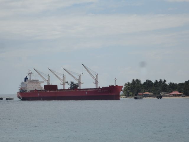
Big ship was still at the limestone conveyor. None of this slowed them down.


No really, this is about bridges.

 
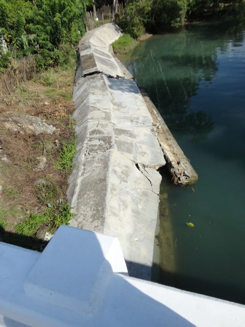
Got out on the road and it wasn't long before we found damage. Right next to this embankment is a heavily damaged house and I talked to the owners but didn't feel comfortable taking a picture.


This looks ready to come down.


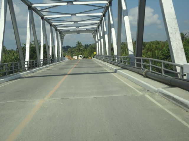
Then we got to the Loboc River bridge and...it is okay! That's very good as it would be difficult to replace its so huge.


The mighty Loboc keeps rolling along under the okay bridge.


We find another okay bridge. At this point we're getting giddy. "Honey, if we get to Tag lets buy bread."

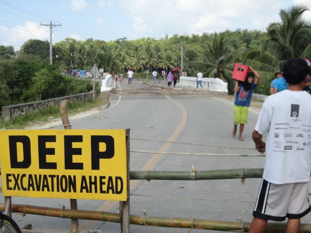
Then we hit this:

 
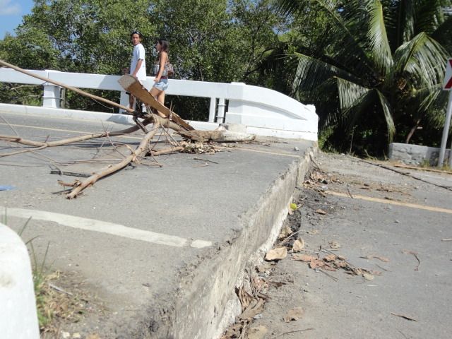
There's a bump...


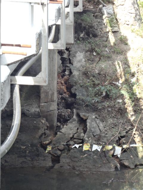
In the basement, four posts on either side, all 8 are cracked.


On the other side there's one of these.


Net result, no bread. :dunno:

Edit: Interesting 2 hours this morning...

21 Oct 2013 - 09:12 AM 10.06 124.15 007 5.2 056 km N 35° E of Tagbilaran City
21 Oct 2013 - 07:34 AM 09.82 124.05 005 4.9 029 km N 48° E of Tagbilaran City
21 Oct 2013 - 07:03 AM 09.92 124.04 010 5.4 037 km N 34° E of Tagbilaran City
 
Still fairly strong aftershocks/activity nearly a week after the incident. I hope nature gives you guys a break soon.
 
on the plus side its far better to have a bunch of smaller quakes than a big one like Chile, Japan or the Christmas tsunami

there's a place in SoCal that gets quakes all the time but they're relatively small, they get so many seismologists love the place for the data it produces
 
Back
Top Bottom