I'm not.Are we very attached to expanding Scandinavia?
- Home
- Forums
- CIVILIZATION IV
- Civ4 - Creation & Customization
- Civ4 - Project & Mod Development
- Civ4 - Rhye's and Fall of Civilization
- Rhye's and Fall - Dawn of Civilization
You are using an out of date browser. It may not display this or other websites correctly.
You should upgrade or use an alternative browser.
You should upgrade or use an alternative browser.
Alternative Map for DOC
- Thread starter Bautos42
- Start date
Ani Taneen
Warlord
- Joined
- Mar 1, 2015
- Messages
- 278
If we have feedback for an area, what's the best way to present it? Get a copy of the map and push it on git? Or get a screen shot and point things out?
For maps, screenshots of either the current map with signs for what you'd change or a changed map with signs for what you changed are good. A couple of posts ago I linked a Canada proposal that I consider exemplary.
AtlantaMarty
No longer active
In all seriousness though, the Levant is one of the most important/contested areas in the game, and adding the extra row would probably make it better, in addition to solving crowding issues with Sardinia and North Africa.
But since you're more interested in non-European areas, I would recommend adding one more tile to Cuba, for a more realistic shape

But since you're more interested in non-European areas, I would recommend adding one more tile to Cuba, for a more realistic shape
AtlantaMarty
No longer active
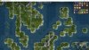
Here's my proposal for city placement in eastern America.

inthesomeday
Immortan
- Joined
- Dec 12, 2015
- Messages
- 2,798
Actually I might be interested in trying one of those. What post number is the one containing the most recent accepted North America?
Well a lot of people know America, but probably don't look at it in Civ. Florida looks too fat but maybe can be longer. Texas is at least one tile too far into the gulf (Gulf of Mexico is too small). There is probably too much grasslands west of the Appalachians all the way to Alaska, probably should not have grasslands in the northwest - Chicago, Detroit, and beyond. Dakotas might as well be like Alaska. The northeast coast of the Pacific (NA west coast) doesn't have its S curve but I guess this is because the Pacific is shrunken. The Sierras are too close to San Francisco. Central California grasslands should not be coastal.
Maybe the Levant can have better tiles instead of more tiles. Resources make the area stronger earlier and crowding is not a bad thing.
Actually the details of the map are quite good, but the more I look at it, the more I rather we have much much less land and much much more water.
Maybe the Levant can have better tiles instead of more tiles. Resources make the area stronger earlier and crowding is not a bad thing.
Actually the details of the map are quite good, but the more I look at it, the more I rather we have much much less land and much much more water.
Jarlaxe Baenre
Emperor
Well a lot of people know America, but probably don't look at it in Civ. Florida looks too fat but maybe can be longer. Texas is at least one tile too far into the gulf (Gulf of Mexico is too small). There is probably too much grasslands west of the Appalachians all the way to Alaska, probably should not have grasslands in the northwest - Chicago, Detroit, and beyond. Dakotas might as well be like Alaska. The northeast coast of the Pacific (NA west coast) doesn't have its S curve but I guess this is because the Pacific is shrunken. The Sierras are too close to San Francisco. Central California grasslands should not be coastal.
Maybe the Levant can have better tiles instead of more tiles. Resources make the area stronger earlier and crowding is not a bad thing.
Actually the details of the map are quite good, but the more I look at it, the more I rather we have much much less land and much much more water.
To me, it looks like the grassland/plains shift happens at the actual transition.

As well, are you suggesting that the Dakotas be made into tundra? Because that is definitely not what they're actually like, and areas north of them are quite agriculturally viable.
Here's my proposal for city placement in eastern America.
View attachment 485215
Boston: that'll do to my eyes it should be 1SE on a new tile
Chicago: 1N & if the iron is the Mesabi Range it should be 2N
Atlanta: 1S of the coal hill
Memphis: 1E so it's on the right side of the Mississippi
New Orleans: I didn't notice how bad the birdfoot delta is with this map but it should be 1N
Dallas: Should be Houston (but then Houston should be 1N of the jungle & Dallas 1NW of it along the river)
AessaSH
Warlord
- Joined
- Sep 9, 2012
- Messages
- 199
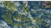
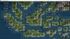
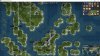
After learning the existence of map border east of New Zealand, I realized that New Zealand cannot be moved further to east, thus creating another limit for enlarging the SEA.
In other words, my previous map can't be used. Oh well..
New design:


Purple : The edge of the map
Black : Moved 1S
Red : Moved 1S + 1E
Green : Moved 1E
Yellow : Major redesign
In other words, my previous map can't be used. Oh well..
New design:
Spoiler The Revamped Areas :
Purple : The edge of the map
Black : Moved 1S
Red : Moved 1S + 1E
Green : Moved 1E
Yellow : Major redesign
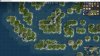
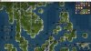
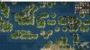
Spoiler Resources :
Here is the distribution of major resources (native and colonial) mirroring the real life placement. Further adjustment is still needed for the game balance.
Also, generic resources that can be found in this area are Clam, Corn (colonial), Crab, Deer, Fish, Pig (pre-Islamic era), and Dye.


Also, generic resources that can be found in this area are Clam, Corn (colonial), Crab, Deer, Fish, Pig (pre-Islamic era), and Dye.
Attachments
AessaSH
Warlord
- Joined
- Sep 9, 2012
- Messages
- 199
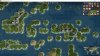
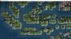
Possible City Placement
Note:
Egypt = Malay states
China = Java-Bali states
Babylon = Brunei-Sulu states (Optional civ, but nice addition to fill the Philippines and becomes the rival of Spain in this area)

Pikatan fought his brother in law Balaputra, splitting the empire into Srivijaya for Balaputra and Medang for Pikatan:

Gajah Mada's conquest. Malay is a vassal of Java:

Brunei was tributary to the Javanese, but sought and received Chinese protection:

Bolkiah's expansion:


Note:
Egypt = Malay states
China = Java-Bali states
Babylon = Brunei-Sulu states (Optional civ, but nice addition to fill the Philippines and becomes the rival of Spain in this area)
Spoiler Core Area :
Spoiler Srivijaya (650 AD) :
Dapunta Hyang's expedition:

Spoiler Sailendra Dynasty (800 AD) :
Dharanindra's campaign:

Spoiler Medang (856 AD) :
Pikatan fought his brother in law Balaputra, splitting the empire into Srivijaya for Balaputra and Medang for Pikatan:
Spoiler Majapahit (1365 AD) :
Gajah Mada's conquest. Malay is a vassal of Java:
Spoiler Brunei (1408 AD) :
Brunei was tributary to the Javanese, but sought and received Chinese protection:
Spoiler Brunei (1500 AD) :
Bolkiah's expansion:
Spoiler Colonial Era (>1500 AD) :
AessaSH
Warlord
- Joined
- Sep 9, 2012
- Messages
- 199
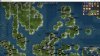
Also, I'm attaching the rest of my map infos.
Attachments
-
 Maritime SEA - 5 - Islands1.jpg435 KB · Views: 1,208
 -
 Maritime SEA - 5 - Islands2.jpg437.6 KB · Views: 262
 -
 Maritime SEA - 6 - Hills1.jpg421.1 KB · Views: 70
 -
 Maritime SEA - 6 - Hills2.jpg430.2 KB · Views: 66
 -
 Maritime SEA - 7 - Terrains1.jpg431 KB · Views: 70
 -
 Maritime SEA - 7 - Terrains2.jpg427.9 KB · Views: 297
Possible City Placement
Babylon = Brunei-Sulu states (Optional civ, but nice addition to fill the Philippines and becomes the rival of Spain in this area)
View attachment 485369 [/SPOILER]
Brunei was a Malay sultinate.
Agreed, also, we should have St. Louis not Kansas City, as the former was far more important and should be 1E of KC. St. Louis was in the top 5 cities from 1870 through 1910 and didn't drop out of the top 10 until 1970Boston: that'll do to my eyes it should be 1SE on a new tile
Chicago: 1N & if the iron is the Mesabi Range it should be 2N
Atlanta: 1S of the coal hill
Memphis: 1E so it's on the right side of the Mississippi
New Orleans: I didn't notice how bad the birdfoot delta is with this map but it should be 1N
Dallas: Should be Houston (but then Houston should be 1N of the jungle & Dallas 1NW of it along the river)
What a great suggestion to come back to after the weekend! A couple of questions:
- I think Kalimantan looks a bit wide, have you tried making it one tile less wide?
- What is your concern about the wraparound map edge and New Zealand? I don't think anything bad would happen if the edge runs through it.
- I think Kalimantan looks a bit wide, have you tried making it one tile less wide?
- What is your concern about the wraparound map edge and New Zealand? I don't think anything bad would happen if the edge runs through it.
Temujin8k
Fluyts, Grand Vizier of Your Mind
The Philippines looks good to me too. Could be this one or the one I proposed months ago. I'm iffy about connecting the Visayan islands, though...
AtlantaMarty
No longer active
Adding 2-5 more columns in the Pacific might helpAt this point, I could easily move the map edge or even enlarge/shrink the map. Although it would obsolete the work I did on some of the XML-files, it is far more feasible than after the City-Name-Manager and Stability-Maps are finished.
Jarlaxe Baenre
Emperor
Adding 2-5 more columns in the Pacific might help
And would slow things down by adding a bunch more tiles the game needs to take into consideration.
You just don't stop do you.Adding 2-5 more columns in the Pacific might help
Similar threads
- Replies
- 12
- Views
- 1K
- Replies
- 5
- Views
- 679
- Replies
- 3
- Views
- 676
- Replies
- 3
- Views
- 792