Alternative Map for DOC

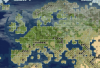
I really like what you did to the Philippines, I'll implement these changes as soon as I can. One thing, though. Considering the size of the Philippines, I'd opt for a two cities setup, probably Davao and Manila, therefore, the Copper should be moved to a tile where it can be worked by at least one of those two cities. (Realism is great, but we should always think of gameplay, and having the copper out of reach of those cities would only make them sub-par. Generally, Korea and Indonesia have to be reworked again, as I made them too small (although, I think two cities for Korea are enough)

Well, maybe because I'm biased about this I wanted to make a 3-city Philippines possible, especially because aside from historical significance it also has economic significance. At least in the Philippines. It's the most developed city in the Visayas (central PH Islands), actually. As a Filipino I just felt like Cebu really had to be there. (I hope inthesomeday agrees with me on this... :lol:)

Spoiler :
(Random fact: I am actuallly from Davao, but I am currently studying in Manila right now. Still, I really want Cebu present. :lol:)


About the copper,... why did I just realize that now? We can put copper instead of gold on the Butuan tile. Scrap the gold, I guess, but it's fine. I missed that, apologies!

Concerning Florence, I think the tile added to Italy makes Italy look weird. Just place Florence one tile north. This would prevent having Florence and Milan at the same time, but having both cities would be a bad idea anyways, as this would rob those cities of some much needed space.

Point taken. I guess I'm the only one who does not find it weird. Oh, spatial constraints. :lol:

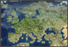
I've done something similar already, as I designed the entire map around what I considered the 'canonical city placement'. (I.e. there always can be Lübeck instead of Hamburg or Florence instead of Milan, but generally there are similar same spots for cities to appear in game). While your take often agrees with what I envisioned, there are other notable changes, particularly in In north America. I think you got the geography wrong, I.e. some cities like Vancouver or New York are far from where they should be.

Oh, I haven't seen it; was looking for that. I actually had a hard time in North America. Thing is, I merely based on Google Maps because (1) repeated Alt+Tab is so annoying and takes a long time, and (2) I don't have an RFC modmod map to base city placements on, unlike RFCE/SoI/RFCA. I took into account the difference in the type of projections used in your RFC map and in Google Maps as well as relative distances to certain geographical features, but when I looked at Google Maps, Washington and New York looked really near. Which one is wrongly placed, Washington or New York? I'm guessing it's Washington--I may have estimated placement wrongly.

Currently you already have to choose between Milan and Florence, which is fine considering the scale of either map. Having Milan in 3000 BC and 1700 AD and Florence in 600 AD is fine imo.

Also, please convert bitmaps to a compressed format in the future, that was a 4 MB image download :lol:

Oh well, I guess there's no option--one has to go... :'( :lol:

I actually planned to do that right away, but I still had to install Microsoft Office Picture Manager 2010 on my laptop before I could easily batch convert them to PNG format since I forgot to do so when I got this laptop. Forgot to get back on it since I was cramming for an exam early today. Anyway, it's in progress already, the Google Drive folder should be updated by now. Again, my apologies. :lol:
 
Last edited:
Pinoy-American here. Born in St. Louis, raised in San Diego. Family's from Iloilo City, and can confirm that Cebu is an economic necessity not only for the future native Civ but also to the Spanish, Japanese, and American occupiers.
 
Also just caught this typo, it should say 80 x 150

Thanks, already fixed.

Well, maybe because I'm biased about this I wanted to make a 3-city Philippines possible, especially because aside from historical significance it also has economic significance. At least in the Philippines. It's the most developed city in the Visayas (central PH Islands), actually. As a Filipino I just felt like Cebu really had to be there. (I hope inthesomeday agrees with me on this... :lol:)

About the copper,... why did I just realize that now? We can put copper instead of gold on the Butuan tile. Scrap the gold, I guess, but it's fine. I missed that, apologies!

Oh, I haven't seen it; was looking for that. I actually had a hard time in North America. Thing is, I merely based on Google Maps because (1) repeated Alt+Tab is so annoying and takes a long time, and (2) I don't have an RFC modmod map to base city placements on, unlike RFCE/SoI/RFCA. I took into account the difference in the type of projections used in your RFC map and in Google Maps as well as relative distances to certain geographical features, but when I looked at Google Maps, Washington and New York looked really near. Which one is wrongly placed, Washington or New York? I'm guessing it's Washington--I may have estimated placement wrongly.

Pinoy-American here. Born in St. Louis, raised in San Diego. Family's from Iloilo City, and can confirm that Cebu is an economic necessity not only for the future native Civ but also to the Spanish, Japanese, and American occupiers.

I apologize if this is seen as offending, but I do not think the historical relevance of the Philippines justifies three cities. The Philippines are certainly a great country, but comparing to regions of similar sice like England or Japan it just never had as much impact on world history. Now a 2 cities solution is already an improvement compared to the current one city situation. I personally see having two decent cities as much preferable than having three cramped cities just for the sake of having three cities there. If you're concerned about a potential civ there, two cities are enough to support a civilication (current Korea). Anyways, there are other historically more "important" civilizations like the Turks still not represented, so I do not see a Philipine Civ in the near future anyways. (Until Leoreth has reworked the Civ slot mechanics).
 
About the copper,... why did I just realize that now? We can put copper instead of gold on the Butuan tile. Scrap the gold, I guess, but it's fine. I missed that, apologies!
From a colonisation perspective, gold is probably more attractive.
 
Canada changes...

I would like to give you a compliment on the detailed explanation of the changes. Together with the screenshot with the landmarks it is really clear what you changed. This makes it a lot easier for others to implement changes. :goodjob:
 
I agree, the rationale behind is always very useful.
 
I really like what you did with Qinghai, but Shandong looks weird and too small. I'm no cartographer, but I have some suggestions from a historical standpoint.

Would be more realist with more river tiles in Sichuan, the Pearl River Delta, and Transoxiana, and more mountains and hills in southeastern Central Asia, surrounding the Hexi corridor, Chongqing, and large parts of southern China. Would be more fun if there was better defensive tiles and choke points in Bozhou Tusi, northern Sichuan, Hexi corridor, Shanhai pass, the Huai river area, and Myanmar. If that lake in east China is around Suzhou, may I suggest another lake around Hangzhou. The split in Vietnam looks a bit too far south.
 
Last edited:
Something not very important but to note for future revisions: there should be a mountain pass to Tibet from the Kashmir region.
 
Something not very important but to note for future revisions: there should be a mountain pass to Tibet from the Kashmir region.
I will focus on it when adjust china region.
 
So something more like this?

Spoiler :
usa-west-coast-2-png.474321

I'd move the outlet of the river 1N to better represent the bay & Golden Gate.
 
Some more suggestions

1. Add 1 more tile to the west coast of Ireland to smooth it out - it looks better and is more realistic
2. Add 1 more tile to southwestern Iberia so it is more square
3. The northern coast of France and Holland looks off to me, but I'm not sure how to improve it.
4. Move Britain and Ireland 1N and 1E, for more realistic placement vis-a-vis the rest of Europe.
5. Make Lake Michigan somewhat wider

Here's a (badly) photoshopped version of the map showing Britain and Ireland shifted
 

Attachments

  • Screen Shot 2017-07-17 at 9.50.16 AM.png
    Screen Shot 2017-07-17 at 9.50.16 AM.png
    569.9 KB · Views: 173
I really like what you did with Qinghai, but Shandong looks weird and too small. I'm no cartographer, but I have some suggestions from a historical standpoint.

Would be more realist with more river tiles in Sichuan, the Pearl River Delta, and Transoxiana, and more mountains and hills in southeastern Central Asia, surrounding the Hexi corridor, Chongqing, and large parts of southern China. Would be more fun if there was better defensive tiles and choke points in Bozhou Tusi, northern Sichuan, Hexi corridor, Shanhai pass, the Huai river area, and Myanmar. If that lake in east China is around Suzhou, may I suggest another lake around Hangzhou. The split in Vietnam looks a bit too far south.
May I ask what you refer to when you mentioned the lake around Hangzhou? Thousand Islet Lake or some lake other?

In my reply in #47 I've adjusted the shape of Yellow River, Yangtze River and Zhujiang River, also add Qiantang River and Min River(Fujian). Next I'll do more adjusts about resourses distribution and terrain changes(by year, for example, Manchuria could be marshes before Mongolia spawns).
 
I'm also thinking about Japan. The most important region there is southern Honshu, which needs to contain the two most important cities (Edo/Toukyou and Kyoutou). On the other hand northern Honshu takes up a lot of space and is neither very densely populated nor historically relevant. I wonder if it is possible to modify the island somewhat to make that possible with a realistic location for Toukyou (i.e. not on the east coast).

While doing research I also don't really understand the river there. The longest river in Japan is the Shinano, flowing north from the center of southern Honshu toward Niigata. The most important probably is the Tone which drains the Kantou plain and supplies Toukyou. Rather than whatever the current river is meant to represent (Abukuma?) there should at least be the latter.

Map of Japan if you want to look for yourself (warning large).
 
Some more suggestions

1. Add 1 more tile to the west coast of Ireland to smooth it out - it looks better and is more realistic
2. Add 1 more tile to southwestern Iberia so it is more square
3. The northern coast of France and Holland looks off to me, but I'm not sure how to improve it.
4. Move Britain and Ireland 1N and 1E, for more realistic placement vis-a-vis the rest of Europe.
5. Make Lake Michigan somewhat wider

Here's a (badly) photoshopped version of the map showing Britain and Ireland shifted
I've figured out how to make France and Holland look better. Just move Iberia and France 1 tile North. Here's a map of that (also with Britain shifted)

Also, Corsica would be better off attached to Sardinia or nonexistent then attached to mainland Italy.
 

Attachments

  • Screen Shot 2017-07-17 at 11.17.23 AM.png
    Screen Shot 2017-07-17 at 11.17.23 AM.png
    575 KB · Views: 243
Most of the land in Tohoku can be worked by Tokyo so not the biggest deal if it's a bit richer than the real region. It would be great if Tokyo and Kyoto could both fill most of their fat crosses with land tiles and didn't overlap so much; even with lots of resources on Honshu those cities just do not cut it later on in the game. The Kanto plain is so rich, populous, and important late game that I think you could justify an FP-grassland-rice tile. I would also replace all the mountains in Japan with plains hills; the place has a dire need of hammers
 
By the way, I've already made an initial version of the city placements. The screenshots gallery, as well as the savefile, can be found here. :)

This savegame is based on yesterday's latest commit (most recent commit in link) rather than today. Not sure if still compatible, haven't tested yet, but since Leo modified C++ header files in the DLL, I doubt it's still compatible.
Some suggestions for improving accuracy of the cities in Central Europe
1. Move Koenigsberg 1N and 1E. Not only is it more accurate, but it also makes room for Danzig
2. Move Cracow 1N and 1W
3. Move Warsaw 1E

Also, Palermo (1W of Catania) would be a better choice for the Sicilian city than Catania. It's both the regional capital and a much larger city.
 
Last edited:
Most of the land in Tohoku can be worked by Tokyo so not the biggest deal if it's a bit richer than the real region. It would be great if Tokyo and Kyoto could both fill most of their fat crosses with land tiles and didn't overlap so much; even with lots of resources on Honshu those cities just do not cut it later on in the game. The Kanto plain is so rich, populous, and important late game that I think you could justify an FP-grassland-rice tile. I would also replace all the mountains in Japan with plains hills; the place has a dire need of hammers
That was sort of my point; if you found Toukyou in the correct location you increase overlap with Kyoutou, so why not found a city in Tohoku instead? I agree about fertility in Kantou though.
 
Something not very important but to note for future revisions: there should be a mountain pass to Tibet from the Kashmir region.
A route from South Xinjiang to Kashmir, in China we call it Aksai Chin. It's an important route from Xinjiang to India in Ancient time.
Spoiler :
mx0nr5.jpg


Also hesitate if to change a peak in Sikkim to hill, I prefer not to change, because in the East there is also a route from Tibet to India(along the Yarlung Zangbo River). At the same time add a cow in Tibet to represent yaks.
Spoiler :
5nlnvp.jpg

Woah, I just noticed you're from China. I'm honestly a little shocked I didn't pick up on it sooner, XD.

How are you accessing this site? Does China not block it? Given the little info I've heard about it's "Great Firewall" as it's called it sounds like it blocks most positive discussions of democracy, though I may be misremembering or confusing it for something else. Is this site just not on their radar? Is the civ series okay despite it's usage of democracy as a civic in basically all the games?

Sorry if it's a lot of questions, China in particular is just a very interesting topic from a internet usage perspective, you know what with how internet censorship's been a pretty big topic not just pertaining to China but even also to terrorism and extremism here in the west.
 
I think that conversation is better had via PM.
 
Back
Top Bottom