soul-breathing
Emperor
When I enter the alternative map, the game auto-play by turns, and can't stop it. How can I stop it and edit the map in World Builder.I meant this one.
When I enter the alternative map, the game auto-play by turns, and can't stop it. How can I stop it and edit the map in World Builder.I meant this one.
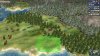
You could repurpose the National Park graphic from HR for this. The trees are separate from the base model and can easily be removed if desired. I've never quite got them to line up properly, thus the tree in the water when viewed from certain angles.
That's a great idea and worth trying.
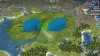
I think at best they should have a commerce or production bonus (+1 tops). That way any bonus would still be limited by food production which would be difficult to boost. I think a bonus is reasonable though, many lakes made the Rideau Canal possible in Eastern Ontario which was built as an important route in case of war with the USA. The many lakes and rivers of Canada made the fur trade across the continent viable before there were any roads.I'm not familiar with Finland but most of the parts of Canada with a lot of lakes are actually mostly to completely uninhabited, utterly unproductive land (in game terms, it's currently represented by tundra), so I don't think it should give any sort of tile bonus at all.
I think at best they should have a commerce or production bonus (+1 tops). That way any bonus would still be limited by food production which would be difficult to boost. I think a bonus is reasonable though, many lakes made the Rideau Canal possible in Eastern Ontario which was built as an important route in case of war with the USA. The many lakes and rivers of Canada made the fur trade across the continent viable before there were any roads.
When I enter the alternative map, the game auto-play by turns, and can't stop it. How can I stop it and edit the map in World Builder.Here are the files for the new map. I used the map from Bautos from this post. And the python files from this post. All files are updated to match the latest update. I also included all new files which are required to make it work, such as the art for the new resources.
It is playable in the sense it does not crash, but many features still need to be updated to the new map.
Commerce might be okay and is at least somewhat thematically appropriate (although really that might still be giving too much credit to those areas), but production definitely doesn't make any sense either IMO.
I can't wait until this becomes the DOC map.
In case this has not been mentioned, I think the UHVs mentioning control of a certain percentage of land and/or population should be checked.
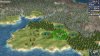
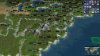
EDIT: Am I seeing wrong or that Central Europe can support many more cities than the current map? It looks like Berlin, Hamburg, Frankfurt, Königsberg, as well as Danzig, Munich, and Prague fit there.
This is likely due to some other error, enable Python exceptions and then fix it.When I enter the alternative map, the game auto-play by turns, and can't stop it. How can I stop it and edit the map in World Builder.
I use the map on #844