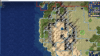
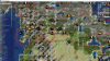
Took a look at Canada today as well. The size-3 cities represent the actually important Canadian cities, while the size 1 cities are more just space-fillers that are important in their area and could be considered the "canonical" settlements but are pretty much irrelevant in the greater picture of the country. In some cases where there are two nearby cities of similar size/importance which could easily alternate, I chose the larger one and represented the smaller with a town and a label/landmark (specifically, Regina and Edmonton).
I assume that Montreal is going to be kept Canada's capital, since there isn't really a way of fitting in Ottawa as well unless we're going to have Toronto-Ottawa-Montreal-Quebec all crammed two tiles apart (unless this is indeed what you're planning?). This is the most geographically accurate position, but it's pretty close to Quebec (which is already a bit further west than it really should be) - were you thinking of it being 1W or 1SW of my position? In that case the upper St. Lawrence and Ottawa rivers should be adjusted. I also already moved part of the Ottawa river 1E; it makes the Ontario/Quebec border look less strange.
IMO, Nova Scotia looks better without the SW tile, but I can easily see why you would want it there. It doesn't really matter either way.
The island tile in the southern Gulf of St. Lawrence represents PEI.
I changed a couple of grassland tiles to tundra tiles, since those areas are almost completely uninhabited (this is pretty much my benchmark for what to put as tundra).
It's not on the original map either, but I added marshes to represent the Hudson's Bay Lowlands, which is isolated, inaccessible, and very sparsely located even by the standards of the area.
I also added an island tile to represent the Belcher Islands
I extended the Red River a bit south so that it actually flows into the US.
A couple of grassland tiles were in added in the
Peace River Country, which is actually inhabitable and farmed despite being so far north.
I also added another grassland tile so that Prince George can be settled.
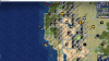
I assume you originally had Vancouver just south of the Fraser River? That is more geographically accurate, but I think it would be better to move the peak on the north side of the mouth 1N and make that the site of Vancouver - after all, the city is on the northern side of the river, but more importantly it squeezes it less against the US border and makes coexisting with Seattle more viable.
I moved the Yukon grassland tile from Dawson City to Whitehorse, which I would say is overall the same importance (Dawson City was important early on but has declined to basically nothing while Whitehorse is the absolute centre of the territory), but Whitehorse is a little warmer than the rest of the territory and it makes more sense to have the grassland tile there. If you decide to change the Alaska Panhandle and add a spot for Juneau, it wouldn't be a crime to move Whitehorse 1E so they can coexist better (i.e. swap places with the copper), although then you might want to adjust the Yukon River as well.
I made the mouth of the Mackenzie River tundra instead of ice, since that area is a little warmer than to the east; it also allows for the settling of Inuvik (if for some reason you wanted to do that), the only community of any importance on basically the entire northern coast.
I adjusted the size of the Great Slave Lake; I'm aware that the tilt of the lake makes it plausible to have the eastern tile 1N, but the shape just looks totally wrong that way. I also removed one ice tile from the lake, to make Yellowknife settleable.
I also rearranged a bunch of resources; I'm not sure what you had planned for the post-Columbian exchange resource spawns, so I used the current 1700 AD scenario as a reference point for that. Mostly it's for increased geographical accuracy (e.g. moving the Newfoundland fish to the Grand Banks, the Alberta Oil back to the oilsands, the Prairie wheat to Saskatchewan). I also added some resources - I'm not sure what the plan the ultimate plan for the number of resources is, so consider this a maximalist proposal. In order of importance, they are:
- 2 Furs on the Hudson's Bay coast - I'm surprised that this doesn't exist already TBH, considering that the entire point of Rupert's Land was to collect furs - currently there is absolutely no benefit or incentive whatsover to settle there as England, at least this way it'll be a marginally smaller waste of resources. If nothing else, I really think that these should be added. Partially compensated by the below:
- Replaced Labrador fur with iron - the fur trade never really operated much in the area, but iron was always important in the region. If that's too much iron (probably not, Canada only has 2) you could probably scrap the resource spot altogether, since there's still the aluminum.
- Replace 1 Northwest Territories gems with gold - TBH I was never sure why the eastern gems were there at all, there certainly isn't anything there at the moment. Gold is what Yellowknife was founded for, so it seems appropriate to have it nearby.
- Added Sudbury copper - represents Sudbury's famous nickel mines, which also produce copper, and gives Toronto a production resource.
- Added Yukon copper - an important industry in the area but mostly a replacement for the silver that I moved to northern BC.
- Added BC gold - represents the various gold rushes in the region that led to the founding of BC, as well as the subsequent gold mining. Not really all that necessary, but if you think that this would give BC too many resources I would remove the copper first, especially if you add one to Whitehorse.
- Added Lake Superior gold - represents the mineral wealth of northern Ontario, and gives a reason for Fort William/Thunder Bay to be settled (along with the moved copper. although that is still intended for Winnipeg). Could be replaced by some other metal if you think Canada has too much gold, like silver.
- Added Cape Breton coal - i.e. the Canadian extension of the Appalachian coal industry. Historically important, not so much anymore. Not that important to add, but it does give Halifax some production.
- Added Great Slave Lake fur - Represents the reach of the fur trade into the north. Not important though, could easily be ignored if you think that there would be too much Canadian fur or make the north too rich.
- Added Nunavut copper - I'm not really all that sure that this should be added at all to be honest, but provides a slight reason to settle Rankin Inlet (the only settlement of note in the northwestern shore of Hudson's Bay). Definitely not important.


")