cephalo
Deity
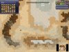
One form of 'islands' on the Arrakis map are the Dunes. Can we use those in some way? Plenty of spice out there too.
Final Frontier does this for the starbases. Because of this, if you destroy a starbase the ownership it was spreading to the tiles around it goes away without specifically doing anything.
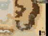
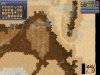
The terrain seems to have stabilized for now. Would there be any interest in me making an actual Arrakis scenario map, based on the north pole map from the books? I've never made a map before, but it seems like it could be fun.
Creating the whole thing by hand in World Builder would take ages.
I feel pretty strongly that no-terraforming until you have a Reservoir (the second of the two buildings, so requiring a high level tech) is a bad way to go.
Suggest alternative: terraforming begins as soon as you have way of liet civic. [Or way of liet civic and at least 1 catchbasin]
Terraforming happens only on fresh water plots.
Fresh water comes only from wells.
Catchbasins provides fresh water in 1 tile radius around the city.
Reservoirs provide fresh water in 3-tile radius around the city.
Each of your tiles with fresh water has X% chance to terraform up 1 step per turn.
X = a + b*#catchbasins you control + c*#reservoirs you control.
Maybe:
a = 1%, b=0.25%, c=0.5%.
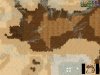
This is the BMP to WBS converter - it's just a time saving way of making scenario maps.
My fear is that this is hard-coded in the game engine.
I thought building placement is related to the lsystem...
")