Discribe your home city.

Well....I guess my home town would be Summerford, Newfoundland, Canada

Pop: 1,200
Ethinc Breakdown:
100% White English
Religious Breakdown:
Pentacostal
United Church
(Other denominations are in near-by towns)
Gas Stations: 2
Restaurants: 1
Grocery Stores: 1
Schools: 2
Churches: 2

Summerford is made up of two parts, the mainland part...and Strong's Island. Strong's Island is where most of the fisherman live, as it's much easier to access the water from there. (Also where my Father lives)

The main part of town is where the "richer" people live (Where we lived for 5 or 6 years after living on Strong's Island for 3 or 4) It houses the Government Wharf, and is the link to other towns in the region. Cottalsville Pop: ?00's 2 minutes away. Twillingate, Pop: 8000, 30 minutes away. Other surronding towns within 1 hour drive: Morten's Harbor, Parkview (renamed from Dark Hole ;)), Virgin Arm, Hillview, Fairbanks, Boyd's Cove, Gander Bay, Gander, Lewisport, Crow's Head. There are a lot more...but I can't remember them all....

The town was named after a minister I believe, that opened the first church there.

It's a pretty rural town, most adults don't have much of an education (my father, Grade 7) I am only the second of my family line to graduate high school. And the first to complete a class at University/Collage. Not even my older sister could do that. Most people are fisherpeople. However some teach or work in nearby towns. We have one nature trail. :) One baseball field, and one soccer field. There is another area that has been an ice rink, tennis court, basketball court and hockey court (street hockey).

Anyway...that's about all I can think of right now...

Maybe tommorrow I'll write about the next town I lived in...Gander. :) Then Mount Pearl, and then Ft. Pierce.
 
My hometown in Hampton in the Southern part of New Brunswick Canada.
Pop 4500 with about another 2000 living on the outskirts.
Ethnic Breakdown 99% white 1% other (I saw a black family once)
Religious Breakdown there are 12 different denominations within 10 minutes of the town center.
Gas Stations 3
Restaurants 8 (Eat out places with sit-down spaces)
Schools 5 (High School, Junior High, Elementary, Primary, and a religious private one)

Its exit 154 on Highway 1 20 min east of Saint John. (Saint John has about 100 000 people in and around it). Anyone coming from the New England States into New Brunswick and continuing to Nova Scotia or PEI would drive through Hampton.
There are 6 different main roads to get to Hampton so it is known as a cross road type of a town. County Couthouse and Jail are in the town. As are a few governemnt buildings. About half the town commutes to Saint John and the other half (myself included) are either self-employed doing different things or work in Hampton.
There is a small Industrial park with a Foundry, a couple of Food Distribution warehouses, and some other metal-working shops. There is a small trailer park next to it.
There is the Kennebecasis River running through the middle of town which helped to establish Hampton in the mid 1800s as the river is deep until it gets to Hampton then shallow for a few miles then deep again.
The Southern New Brunswick RCMP Command Centre is located in Hampton. (Makes you want to cower in fear doesn't it :lol: )
There is a small medical center, 2 Dentist offices, 2 large hardware stores, a funeral home, a few parks, a small nature preserve borders the town, 3 or 4 law offices, a large volunteer fire deptartment and a nice sized hockey area. 3 baseball diamonds and tennis courts. Golf course is build ontop of an old land fill near the industrial park. There are also a lot of walking and biking trails.
Basically the only thing we don't have is a clothing store like Wal-Mart. And the 1 grocery store is like a glorified convenience store.
The only reason I come to Saint John is to work 1 day a week and go to Walmart, the movies and shop for groceries.
I like Hampton.
 
well, I was born in Toronto, a city of 5 million, but I now live in Summerside, so I will describe it:

pop-5,000 or so
we have 2 "main streets" one, water street, spans the city from highway 1, to the western edge. where it turns into south drive, and turns north... up to an intersection with, of course, west, east, and north drives :) I live in north drive.
the other main street is granville. the commercial center. in upper granville street, is a super store, 2 malls, a wal-mart and a McDonalds, where I work. there is also a wendys/tim hortens here. and a 5-plex movie theater. just off from granville is the street with the high school. there is a grade-and-jr.high school on that rode, and a grade school, and realating middle school also in the city. along water street is a burger king, 2 malls, a McDonalds, a wendys and a tim hortens, but its more 'dirty' then granville. to the north of the city is highway 2. the pain throufare of PEI, as opposed to highway 1, which connects the bridge {the I in PEI stands for island} to summerside and charlottewotn {the capital}
there are a number of gas stations, and churches, but the city is still pretty nice. to the north ans west is Slemon Park. formerley CFB Summerside, a canadian air-base. its now a residential area. in the rear is an industrial area.

this is pretty well it :) come visit sometime, theres a hotel down the rode from my place, alone highway 2, near an irving, just north of summerside :)
 
heres a pic
summerside.jpg


from water street, just above the yau... yagh... yot club, and one of the downtown malls.
summerside is along the ocean BTW.

edit
looking at the pic
the water is the back is the ocean... so is the water in the front :) malpeque bay and northumberland straight respectivley.

on the right egde of the pic, anbout 23rds of the way up, half cut off by the pic, you can see the high school I attend dayley.

just on the left, you can see an intersecton in the bottom left corner. the street heading up through the city is granville. you can see in the top right quadrent, the gray area, beyonf the trees, where granville should be... thats where the malls are.

at the top right, you can see a row of houses.... one mf which... is mine :)
 
I was born, raised and still live in the great German city of Bremen :)

While I was thinking what to write about this nice place, I came across the city's official website, and lazy as I am I decided to copy the history part out :D

"Free Hanseatic City of Bremen: International seaport and trading centre right near the North Sea. Independent state of the Federal Republic of Germany, consisting of the cities of Bremen and Bremerhaven Two-city state covering an area of 400 square kilometres - smallest of the 16 German states. State's total population: 681,722, thereof 550,392 in Bremen, making it the tenth largest town in Germany, and 131,330 in Bremerhaven. Significance: second most important foreign trade location in the Federal Republic of Germany.

History: 1,200 years old, early centre of the Christian missions to North and Northeast Europe, major role among the towns of the mediaeval Hanseatic League, historically evolved as city republic in the tradition of a trading centre on which patricians left their mark.
The city's history goes back over 1,200 years. And you will encounter it everywhere. In the baroque and Renaissance backdrop of the Market Square, for example, with the Town Hall and the statue of Roland, patricians' houses, and the "Schütting", Bremen's historic Chamber of Commerce. All of them are emblems of Hanseatic republican consciousness - civic pride expressed in stone, bricks and mortar. This is a tradition people in Bremen are proud of.

The historical legacy which has been salvaged from the past is lovingly tended today. Take Böttcherstrasse, for example: once a narrow street where artisans plied their trade, today it is a centre for art and culture and a highlight of European cultural history. Then there's "Schnoor", a picturesque old-city quarter, that has been refurbished and decked out to become Bremen's most popular tourist attraction."
To add a little about more recent history:
Bremen has been its own state already in the Weimar Republic and before, as mentioned in the text above the tradition of independence is quite strong. In the Third Reich that ended of course, when Hitler abandoned federalism. In that time the city was among other things a center of airplane and submarine production and was like most other German cities very much destroyed in the Second World War. After the war the state of Bremen (including Bremerhaven) became the American enclave within the British occupation zone. That was done because the Americans needed a seaport to get their troops and equipment into the country. It stayed like that until the early 90s.

There's more on this site if you click on the little Union Jack on the upper left side of the page.
The city is known for it's beer (Beck's Beer), its football club (Werder Bremen) and it has a university and various other educational institutions. The biggest employer is Mercedes Benz (Daimler-Chrysler), who produce their luxury cars here.
Traditionally big employers were shipyards but since the 80s German shipbuilding has been in a deep crisis resulting in the collapse of the two biggest shipyards here, adding to the unemployment rate, which is now the highest of all West-German states (to be fair, most of them aren't city states, and generally unemployment is higher in the cities). A thing that is not mentioned on the city's page of course... ;)
Another thing worth mentioning is the aerospace industry. Bremen is involved in the European aerospace projects like Airbus and ESA.

Policitally Bremen has traditionally (talking about post-war traditions) been voting Social Democrat until the 80s the SPD usually governed alone. After a term governed by a so-called "traffic-light" (red-yellow-green = Soc.Dem-Liberal-Green) senate a grand coalition (Social Democrats and Conservatives) came to power. They now hold about 80% of the seats, imagine yourself what that means to democracy...
 
Gee, so many people here live in relatively small towns and cities. Tis slightly suprising.
 
Ok, my location field says Omaha, but I really live in Bellevue. But almost nobody knows where Bellevue is. :(

Bellevue is located directly south of,and is contiguous with, Omaha. The Omaha metropolitan area is home to some 700,000 people, of which about 65,000 live in Bellevue. It is the oldest city in the state, and is usually the third largest. (The standing joke is that when the University of Nebraska at Lincoln football team has a home game, the third largest is Memorial Stadium - population 70,000+. :D )

Bellevue was founded in 1823, and got its name for the 'beautiful view' of the Missouri River from the original site. Flooding forced the town to move to higher ground a few miles south after a few years, but the location of the original site is still preserved inside the Fontenelle Forest, a large private nature preserve on the northeast side of town.

Bellevue was originally supposed to be the Territory/State capital, but the governor died a few days after making that decision. The new governor moved the capital to Omaha. Some years later, when Nebraska was on the verge of statehood, another governor made a 'midnight move' to Lincoln, and proclaimed that to be the new capital! (Politicians have been politicians throughout history. :lol: )

Directly south of Bellevue is Offutt Air Force Base, home of the U.S. Strategic Command, which manages the U.S. nuclear forces. North of Bellevue, as I said before, is Omaha. Bellevue is considered by some to be basically a 'bedroom community' for Omaha, but it is a city in its own right. Still, much of Bellevue is oriented north and west, as part of the 'Greater Omaha Metropolitan Area'.

Located in the middle of the country, Omaha straddles Interstate 80, one of the nation's major east-west routes. It has long been a crossroads city; Union Pacific Railroad has its headquarters here. In 1845-46, the Mormons stopped here in a place since known as 'Winter Quarters' on their trip west to Utah.

Omaha is a surprisingly (to some) cosmopolitan city. We have anything that most big cities have, just maybe not as much. For instance, we only have one small opera house. But the point is, we do have that opera house. We have professional sports teams. Not major league, but, hey, most cities don't have those. We are currently (and have been since its inception) home to the Collegiate World Series of baseball. Every June the top college teams from around the country come to Omaha to play for the championship.

Our Henry Doorly Zoo is world-renowned. Not only is it a major contributor in the study of big cats (especially tigers), but we have one of the largest and best 'indoor jungles', and this spring they just opened up the world's largest desert biodome.

That's a quick overview. I could go on about the Omaha-Bellevue area, but it would be easy to exceed post size limitations. :D

If I find some good pictures I may post them.
 
Originally posted by Mikoyan
I live in Vårberg, try to find it on the map!
:D

Found it! 7 stops from the western end of the red line.

Do I win a free trip to Stockholm?
 
Originally posted by dannyevilcat
Ah... Victoria, British Columbia, Canada:
...
Population: 300,000 (amazes me that it's larger than many of the cities I think of as large. Orlando, for instance... it has it's own professional sports teams and we don't!)

I've been to Victoria a number of times and couldn't believe it when you said this, so I looked it up on Encarta. It says that the metropolitan area of Victoria has a total population of about 300,000, versus 186,000 for just the city of Orlando, and 1,644,000 for the metropolitan area of Orlando. So the mixup was you were citing the metropolitan area of Victoria while Palehorse's number was just the city of Orlando.

---------------------------

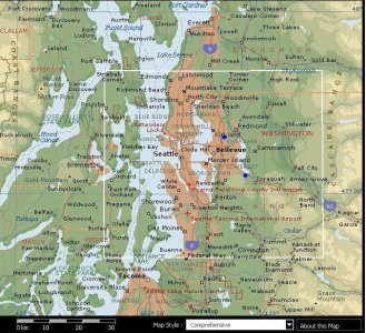
I've grown up in the suburbs on the east side of Seattle, first in Kirkland and now in Issaquah. Here's some excerpts from Encarta about Seattle:

Seattle is the hub of the sprawling metropolitan region of Greater Seattle and is the largest city in Washington. There are 3.6 million people in Greater Seattle, one of the fastest-growing metropolitan areas in the United States. The area’s rate of economic growth led the nation in 1997. This growth reflects the success of local high-technology industries such as aerospace, software, computer and electronic equipment, medical devices and biotechnology, and telecommunications products.

Seattle is located on Elliott Bay in Puget Sound, 182 km (113 mi) south of the border with Canada. The city sits on a stretch of rolling land between Puget Sound and Lake Washington and is surrounded by high mountains and sparkling water. City residents look west to the mountains of Olympic National Park, east to the Cascade Range, and south to Mount Rainier (4,392 m/14,410 ft). Lake Washington and Lake Union, which lies within the Seattle city limits, are connected to Puget Sound by the Lake Washington Ship Canal. The canal threads east and west through the city, and the Hiram M. Chittenden Locks enable seagoing vessels to traverse the different water levels from the higher freshwater lakes to the lower saltwater bay.

Seattle was named in honor of Chief Sealth, the leader of the Native American tribes who befriended the American settlers that founded the city in 1851. The city has a mild climate, and people enjoy the outdoors year-round. Average temperature ranges are 2° to 7°C (35° to 45°F) in January and 13° to 24°C (55° to 75°F) in July. The city averages 940 mm (37 in) of rain annually.

Seattle has experienced steady population growth since the early 1980s. In 2000 the population of Seattle was 563,374, up from the 1990 census figure of 516,259. In 2000 the population of the Seattle metropolitan area was 2,414,616; the population of the Puget Sound urban region centered on Seattle was 3,554,760.

------------------------------

I hardly ever go into Seattle except for Mariners baseball games, because the city of Bellevue is closer and has everything that all large cities have, with high-rise office buildings, malls, museums, concert halls, etc. Here's some sections from what Encarta has to say on Bellevue:

...city in King County, western Washington, between Lakes Washington and Sammamish. Two floating bridges link Bellevue with Seattle across Lake Washington. The city's name, French for “beautiful view,” refers to its scenic setting. The retail, high technology, and service industries are significant sectors of the city’s economy. Manufactures include computer hardware and software and other light industry products. Population 73,903 (1980); 86,874 (1990); 109,569 (2000).

---------------------------------

Here's a map showing the two places I've lived with blue dots:
 

Attachments

  • seattle.jpg
    seattle.jpg
    186.5 KB · Views: 137
Well Monkeyman116- I was very dissapointed to see that Willenhall was left off your map.

Nice to see you got Dudley though.
 
Originally posted by mrog
Well Monkeyman116- I was very dissapointed to see that Willenhall was left off your map.

Nice to see you got Dudley though.

I'm even more disappointed to see that Finland is left off.
Just try to look it; Flood has struck there. Just sea.
 
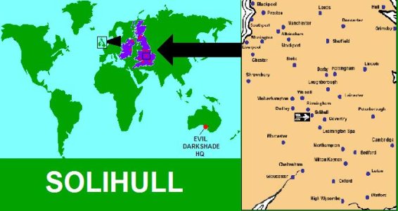
Very nice going, monkeyman from Solihull. :lol: As a reward, the sum of one groat is in the post. ETA November 2167.
 
Charrolette amalie st. thomas US Virgin Islands.
tropical paradise + gang wars. Everyone makes fun of the stupid tourists who are always mad at me b/cause i get to go everywhere for about 1/2 the cost of what they do. The City is almost grimey and the tourists never go there. you can get food from any part of the globe. My house sits above it all, on top of the mountain looking at Megans Bay far below us. the dense plants in my yard need to be cut, live in fear of hurricanes every summer, winter is warm.
 
Helsinki:

Founded 1595, by Sweden, to be market center, instead of Russian Tallinn.
The original reason to built city was obsoloted in 1600's, and
Helsinki had something like 5000 pop. to early 1800's, when Russians
take over Finland. Alexander II made Helsinki to Finland's capital in 1850's,
and population exploded from 9 000 to 45 000.

Capital since independent 1917, nowaydays 550 000 citizens.
 
Back
Top Bottom