Gatoutak's Map Shack

qUqQJ7l.png


(full size)
 
E5iRGEt.png


(full size)

Your Chukchi's Map is great!

Maybe you know that I've made a few modded siberian civs like the Chukchi, Koryak, Evenk, Nenets, Khanty-Mansi and Yup'iks. I'd like to improve them with a unique graphical style. Would you be interested into making some maps for them?

I've added a few to the queue! You're free to use my Chukchi map, by the way.
 
Awesome work! Could you do Medang kingdom for Indonesia Packs split someday if you have time?
Spoiler :
2000px-Medang_Kingdom.svg.png


Translations for some Indonesian text in the map, to make it easier for you:
- Legenda : Map Legends
- Red Dot : Administration center / capital city. Medang have several capitals, hence >1 red dots, due to volcanic eruption that destroy old capital
- Black Dot: Candi or ancient cities/settlements.
- Dark oranges: core areas of Medang.
- Light oranges: (maximum) territory of Medang.
- Black triangle: mountains
- Red triangle: volcanoes
- Periode Jawa Tengah : The original settlement of Medang, before the Merapi volcano erupted and destroy the capital. They then moved eastward. 8th to 10th century
- Periode Jawa Timur : The new settlement, after the eruption. 10th to 11th century
- Garis pantai purba: Ancient coastline shore. Mt. Muria was on another island back in Medang days.
- Samudra Hindia : Indian Ocean
- Laut Jawa : Java Sea
- Sunda Galuh : Another kingdom

Turns out there's already a map version with English text haha.


Many thanks! :)
 
Man those are nice!

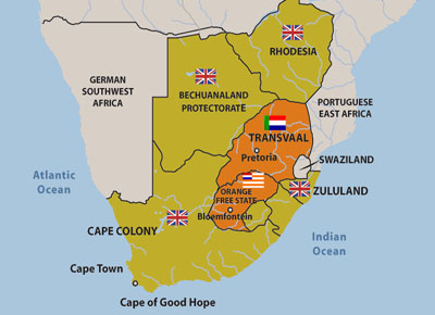
Anyway another small request: British South Africa:
Spoiler :
boerwar_map.jpg


EDIT: Also I saw the Customization Wiki, I would definitely like to see Fiji in the future as a civilization.
 
Would you be able to do a map for Bulgaria? its no specific time period, its just a Bulgaria civ. (Which i admit might make it harder to make, since theres no time frame). The leader is Vasil Levski, but he wasn't an actual leader but rather a National Hero, is that helps at all.
 
Or do Bulgaria in the late 19th century, since thats when Levski was about. Maps usually(ish) date from when the leader lived, there's no Kalmar union for Sweyns map even though it would enlarge his territory quite a bit.

I've always hated Gandhis map, I wish MC's India pack replaced it with a proper map from 1947 with some colonial/early India stuff.
 
There's also the former Brazilian city of Buenos Aires, located in present-day Uruguay. And one of Catherine II's greatest deeds includes sinking Sri Lanka.
 
I always giggle a bit thinking about how thebes is marked on the Egyptian map because its so easy to picture how it happened. Some artist was given the direction to put thebes on the map, googled it, looked at the first result and was like 'huh, well, you're the boss' and then nobody bothered to even question it. Its amazing.

EDIT: Its not even the first result, Thebes in Egypt is the first result. I like to be reminded how even giant companies are still able to make really, really stupid mistakes
 
My favorite map inaccuracy is Indonesia's, in which all of Australia is mysteriously absent.

I suppose I could do an 1878 Bulgaria. Although it barely misses Levski's lifespan, it's the closest independent Bulgaria there is.
 
Back
Top Bottom