RICHMOND, Va. Hurricane Isabel was weakened to a tropical depression by Friday but managed to leave at least 17 people dead and more than 5.5 million homes and businesses powerless.
After wreaking havoc on the East Coast, particularly on North Carolina's Outer Banks and along Virginia beach communities, Isabel raced toward Canada on Friday, soaking some tidal communities along Chesapeake Bay but breezing inland with less rain than expected.
In the Baltimore area, tidal flooding forced rescue crews to take out 400 people, some by boat, as waters rose to the second story of some buildings in low-lying areas.
Thirty-four people and a dog were removed from homes in the city as rescue crews worked their way down Thames Street in an inflatable boat.
The storm was blamed for at least 17 deaths: nine in Virginia, three in North Carolina, two in Maryland and one each in Pennsylvania, New Jersey and Rhode Island.
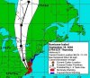
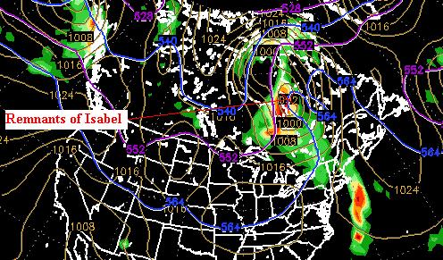
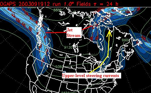
By 11 a.m. Friday, Isabel was 50 miles northeast of Cleveland, moving north at around 30 mph.
According to Accuweather.com, the still weakening Isabel will continue to move quickly northward Friday, merging with a storm system over eastern Canada by nighttime.
A day after plowing into the Outer Banks with 100 mph winds, Isabel moved across Virginia, West Virginia and Pennsylvania on Friday as its winds eased to around 35 mph -- just below the threshold for a tropical storm. The storm dumped as much as 4 inches of rain in Pennsylvania before moving toward Ohio, and was expected to dissipate in Canada by Saturday.
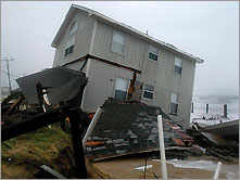
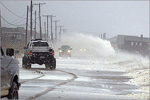
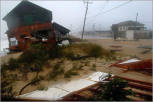
Brighter skies on Friday brought the first good look at the damage along the Outer Banks. Power was out along the entire 120-mile barrier island chain, and the main road was impassable in several stretches, covered with sand, debris and downed power lines.
At least two fishing piers were destroyed and storm surge flooding wrecked several beach houses, sending washers, dryers, trash cans and other debris floating into the street. Federal officials were checking on 4,000 people who refused to evacuate.
Inland residents worked in the brilliant sunshine to repair damage from waist-deep floodwaters that rushed in and quickly receded.
"It kind of looks like they misplaced the bomb for Saddam and dropped it here," said Brooks Stalnaker, 72, whose home collapsed in the inland community of Harlowe. "We just got totaled."
The storm blew down three Baltimore buildings that would have to be demolished and downed trees and utility lines.
In Washington, the federal government shut down for a second day Friday. Offices and monuments were all but abandoned, frustrating tourists.
"I think it's a little overkill," said Los Angeles tourist Sandra de Dubovay. "Some people only have a day here. It is frustrating."
At Arlington National Cemetery, soldiers who guard the Tomb of the Unknowns were given -- for the first time ever -- permission to abandon their posts and seek shelter during the storm but they stood guard anyhow.
West Virginia got up to 5 inches of rain -- but far less than the original forecast of a foot. Flood advisories for parts of the state were canceled. Delaware rainfall amounts averaged 1 to 2 inches, about half of what forecasters were predicting.
Michael Brown, director of the Federal Emergency Management Agency, cautioned that residents in Isabel's path should keep their guard up, with flood waters moving into tributaries throughout the day.
"So people just because they see blue skies should not think, 'Oh this storm is gone and the aftermath is over with,'" he said in a television interview.
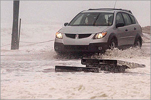
Some of the worst flooding Thursday was along the Chesapeake Bay, where an 8.2-foot storm surge sent water into low-lying areas, particularly in Norfolk and Portsmouth.
About 1.6 million customers lost power in Virginia alone, and more than 16,000 people filled evacuation shelters. Dominion Virginia Power said it would take days to restore power.
"Virginians need to realize that they're in for a tough couple of days," said Gov. Mark Warner.
In Virginia Beach, Ed Barry, 61, spent Friday morning picking up shingles from his roof and his wood fence from his yard in the resort city's north end. "That's the price you pay for living on the coastline," Barry said.
Water service was lost or diminished in many areas because pumping stations lost power; residents were advised to boil water before drinking it.
Richard Staublein, 42, drove his family 13 miles for their first meal in a day, a breakfast at McDonald's in a Richmond suburb -- and waited 50 minutes in line. Many had not eaten because they lost power and were unable to cook.
"I left the house around 8 a.m. and when I got here the line was already a killer," Staublein said.
President Bush declared major disasters in North Carolina and Virginia, ordering federal aid to both states. The governors of Pennsylvania, West Virginia, Maryland, New Jersey and Delaware declared state emergencies.
With mid-Atlantic states left sodden by an unusually wet summer, the winds toppled trees and rains flooded creeks and low-lying areas.
Maryland Gov. Robert Ehrlich said flooding, whether from storm surges on the Eastern Shore or heavy rainfall, was "the No. 1 danger." Officials said 1.25 million customers were without power in the state.
The storm knocked out generators at two water treatment plants and a sewage treatment plant in Anne Arundel County.
County Executive Janet Owens urged residents to be patient and conserve water until power was restored.
"Putting it bluntly, please don't flush," Owens said.
The storm spared much of North Carolina the kind of damage it experienced in 1999 from Hurricane Floyd, which left 56 dead and much of the state underwater.
On isolated Ocracoke Island, about 15 people gathered at Howard's Pub to ride out the storm.
"Isabel's eye passed right over us," said Buffy Warner, the pub's owner. "It was so dramatic. The rain was actually driving horizontally with these incredibly dark skies and no visibility. Then, within about 60 seconds, the sky became bright white."
A utility employee in North Carolina was electrocuted while restoring power, and a man in Virginia drowned while canoeing. Most of the other storm-related deaths were from falling trees or car accidents.
In Middletown, N.J., Isabel sent a tree crashing through the roof of Jean Paul Zammit's house.
"It was a just a big bang and crack, and the ceiling falling down and everything falling down," said Zammit.
Well over 1,500 flights were canceled at airports in the major Eastern cities, said David Stempler, president of the Air Travelers Association.
The Associated Press contributed to this report.
")
 it plays them as a slide show you can watch it like a video as it swirls all over the place)