A new map script (MountainCoast)

lonkero173

Junior Pythoneer
Joined
Jan 7, 2009
Messages
59
A few days ago I was rather frustrated by the absence of a map script that would leave nice open areas here and there, but limit them off from one onother to a considerable degree. The "Erebus" script came close, but the unnatural feel of the mountain ranges was disturbing.

Now I'm too lazy to keep typing so im just giving you a bit from the script 'readme'

"A map script for CIV IV (particularly Fall from Heaven 2)
Heavily inspired by J.R.R.Tolien's Middle Earth as well as the "Erebus" map script by Rich Marinaccio

The main point of this script is to create credible mountain ranges that are large enough to be strategically important without overly
disturbing movement. There should rarely be any absolutely critical chokepoints (lone entrances to valleys), but maintaining control of choke points should be important nevertheless"

Extract the .zip into you [BtS folder]/mods/[whatever FFH version you are using]/PublicMaps
(Will work with(out) any mod excluding the "truly random resources" option)

Should you wish to modify the map script behaviour somehow, there is a large number of variables to be tweaked near the beginning of the file.

Also a big thanks to Doug McCreary for his Fair_Continents script

Due to the author moving on to other projects, no further updates should be expected unless serious bugs in the map are found (sphere / toroid versions excluded).

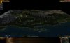
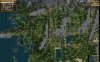
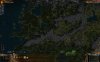
Alll below screenshots from the current version, default settings, standard and huge map sizes. (Taken in Fall Further, thus the unusual civ's/unique features)
Spoiler :


Spoiler :


Spoiler :


1.2.0 is a balance update
1.2.1 should fix multiplayer desyncs
 

Attachments

  • MountainCoast.1.0.0.zip
    20.9 KB · Views: 278
  • MountainCoast.1.0.1.zip
    21.1 KB · Views: 496
  • MountainCoast.1.1.0a.zip
    21 KB · Views: 362
  • MountainCoast.1.2.0.zip
    21.4 KB · Views: 543
  • Civ4ScreenShot0024.JPG
    Civ4ScreenShot0024.JPG
    215.4 KB · Views: 4,811
  • Civ4ScreenShot0026.jpg
    Civ4ScreenShot0026.jpg
    483.6 KB · Views: 4,694
  • Civ4ScreenShot0025.JPG
    Civ4ScreenShot0025.JPG
    318.1 KB · Views: 4,483
  • MountainCoast.1.2.1.zip
    21.3 KB · Views: 1,145
it looks GREAT, and I'm sure it will be a pleasure to play on. I especially like how the mountain ranges look. it also has some serious issues right now though:

1) resources are placed oddly, it doesn't look random at all, they are too packed together and way too abundant, especially the civs' starting spots.

2) floodplains on rivers show up even on plains, which means very very high yields ( totally unbalanced )

3) forests/jungles on peaks: it looks nice, but also weird and I guess they will add health ( remove health if jungles ) in nearby cities even if they are on an unworkable tile, which doesn't seem right.

4) I'm not really sure how the "lakes" and "peaks" dropdowns work. it would be awesome to have lakes on the map of course. but I started a standard size map with lakes set to 2, and there were no lakes to be found. also, selecting "1" or "6" for peaks makes no sense, it should be changed to "few" , "lots" etc. imho. ( could be nice for lakes too: knowing in advance exactly HOW many lakes are gonna be on the map isn't good imho, but being able to choose between "few" and "many" is always great )

5) it seems to generate maps really similar to each other: coast to the west, ice to the north, desert to the south. some more variation on that would be nice. it would be awesome to have options for the map to generate continents, and X/Y wraps.

aside from this pretty serious issues though, it's really awesome. I wouldn't play it right now tbh, but if you fix it I guess I'd play it exclusively instead of Erebus :D

so well done and keep up the good work :goodjob:
 
1) Resources are placed totally randomly (dont underestimate coincidence, by default civ does a lot of non random resource balancing), with the following rules:
Latitude is taken into account (no bananas next to tundra), and, a little thing of mine: basic food resources, in particular deer, are much more abundant than usual
If you want less there is a variable at the start of the script for that

2) I originally thought it would be a good idea to have some extra yield in the large plains, but I agree, its too much... Do you think is should get rid of them altogether or make them an occasional treat?

3) I never thought about the healt issues, most peple don't want cities with half the radius filled with peaks... I think I'll get rid of the jungles but the forests are a nice addition, peaks will be of at least some use then

4) They don't ;) I said it that only world size and sea level are taken into account, I'll get these fixed and add some more soon enough (now I want a bit of a break from scripting...)

5) The similarity is not about to go away anytime soon... the fact that the coast is always in the west made my river generation algorithm feasible (its pretty ugly, the nice one was buggy as hell...but would have supported any map forms..)(Actually now that I think of it, I should be able to adapt it a bit...)
I could change the deser/snow ditribution, the way it is now is due to the "inspired by Middle Earth"(same goes for coast being in the west)
Large inland lakes will be added, thats what the dropdown was meant for originally.

And don't worry, like I said it's still very much work in progress, It should be in a playable condition within the week(assuming more good feedback)
 
I'd take away floodplains on plains tiles entirely, floodplains give 3 food to balance out the fact that they can only be found on otherwise useless desert, placing them on a "good" tile is overkill ;)
 
2,3 and 4 (everything but some climate options) fixed. A couple of other bugfixes, on major (I hate implicit int/float conversions...)
Amount of resources is now dramatically lower.
Should be moreless playable, be carefull not to increase the number of mountain ranges too much, this will result in areas that are entirely closed off (I'll get this fixed at some stage)
 

Attachments

  • MountainCoast.0.9.1.zip
    11.3 KB · Views: 230
new version is a lot better, well done :)

still a couple issues:

1) I still suggest that you get rid of forests on peaks, it's kinda confusing, i.e. it makes it difficult to understand exactly how the terrain is set up with just a quick glance. moreover, I've seen quite a few tribal village on peaks :D

2) resource placement still needs some tweaking. resources that are supposed to clump ( dye, silk etc. ) are not clumping at all, while others that are supposed to be kinda rare ( like corn for example ) are easy to spot next to each other. I guess it needs to be less randomized and more balanced, the default civ4 method is fine imho. strategic resource definitely should not be next to each other ( I've seen an amurite civ with 2 raw mana nodes in their starting 3x3 grid )

3) sometimes rivers flow into a land tile instead of a 1-tile lake or something, which looks weird ( makes you wonder where all that water is going :lol: )

4) lakes are very nice, but way too big imho. since they're more flavourful than useful to the gameplay anyway, I feel they shouldn't take away huge portions of the map.
 
I'm not sure about the peaks with forests. Perhaps a good solution would be to only allow a peak that is next to a non-peak forest to have a forest of its own. So only the outermost peaks of a range would have forests. After all, the center of the range should be highest if it were real-life and thus most likely above the treeline.

I have indeed seen peaks with villages and I've also seen the Guardian of Pristin Pass on a peak completely surrounded by other peaks. Basically impossible to reach.

But what struck me is that these maps are way too big! I generated a Large map which I would more accurately describe as Immense. The Standard size was a bit more what I'd expect for Large maps.
 
1 and 2 are now map options (default to your way),however I like them so they are not going anywhere :king:
3 will need a bit more work, I might have to do at least a partial overhaul of the river system...
4 coming soon enough(tomorrow, gmt+2), I thought they would help a bit with the lack of water (what map size? the size of lakes is still static, I'll get that changed but I've primarely intended this map for large map sizes, anything below "small" is almost guaranteed to be of poor quality...and cahnging this is too much of an operation)
Thanks for feedback, keep it coming and I'll try to keep improving the script.

@Deon
What type of warp are you thinking of? If you want simple continents that just contain a mountain range and a bit of land around it, that should be easy( I might even be able to make it a map option).
However rivers will continue to flow westawards (try find an eastward river somewhere :) ) and moisture calculations will continue to be based on the assumption that wind allways blows from the west.
If you want bigger continents (larger map sizes?), these two issues will have to be addressed, and that will take some time at the very least (no promises, but I'd like to get such a version myself)

Then another general question: do you people think I should keep adding things as map options or just try to get good defaults? (There are a lot of things I could add as map options)

File is attached to the first post.
If someone plays anything resembling a proper game on this map, please comment on it. I only have a finite amount of time (although plenty for a week more), so gameplay feedback is more than welcome.
 
I've started a few games with this, and I must say this script has a huge amount of potential. There are few things I noticed, which I will list in the numerical listing methods which has dominated this topic:

1. The script does not scale too well to map size. Anything smaller than large and the map loses the desert zones to the south and the arctic zones to the north. Also lakes that are just large in the larger map sizes (large, huge), will engulf a quarter to half of the map on smaller sizes (standard and lower). While I love the detail of the larger map sizes, MAF's and lengthy turn load times (not caused by this map, just large maps in general) make anything bigger than standard usually impractical for me to play.

2. Cosmetically, lakes are too round in general, usually resulting in almost perfect circles. Also, there's a bit too much mixing between the climactic zones.

3. Tundra tends to seriously infiltrate the middle grassland regions of the map and can be found as far south as the deserts (though this latter issue may just be on smaller map sizes). Paradoxically perhaps, ice zones in the far north are extremely rare to non-existent.

4. Large contiguous clumps of hills with no mountains in them are kinda odd, but again this may just be an issue on smaller map sizes.

I do believe though that in the fullness of time you will make this map script the only map I ever bother playing. Excellent job!!!!
 
Cool map, but has some issues. From the west coast to halfway inland, everything is fine. However, about halfway inland there was a north south line that looked something like the following:
Code:
hhpp
hhpp
hhpp
hhpp
hhpp
h=hills, p=plains
This line stretched from the northern edge of the map to the southern edge.
Also noticed an almost perfectly rectangular desert on the eastern half of the map, would have been a perfect rectangle with dimensions 12x19. Basically, the map had a great portion starting on the coast, then going in halfway something just went wrong. Although, interestingly enough, only one of the civs spawned in the 'bad' half of the map.

I regenerated the above map and got another, better one. however this one had the shaiem walled of from every other civ by a wall of mountains 5 tiles thick bisecting the map diagonally... And there was a perfectly round island off the coast with a yin/yang grasslands/plains thing.

The third map regeneration was pretty cool, and I am playing a game through on that one. Its only major drawback is that the Khazad are stranded on a very, very long peninsula going north/south that is 90% peaks and 9% tundra. Everything else about it is great though.

Atm I'd call this mapscript a diamond in the rough. Try to tone some of the extremes down a bit. (Thinner mountain ranges, less rectangular deserts, etc)
 
1. The script does not scale too well to map size. Anything smaller than large and the map loses the desert zones to the south and the arctic zones to the north. Also lakes that are just large in the larger map sizes (large, huge), will engulf a quarter to half of the map on smaller sizes (standard and lower). While I love the detail of the larger map sizes, MAF's and lengthy turn load times (not caused by this map, just large maps in general) make anything bigger than standard usually impractical for me to play.

seconded. in fact the "too big" lakes I mentioned earliers were on tiny to standard maps.


@PotatoOverdose: what do you mean by "thinner mountain ranges" ? I know it's pretty self explanatory ( :D ) , just wanna be sure I got that right. basically you're saying that mountain ranges should be less than 5 tiles wide? ( since that seems to be what the mapscript is generating now ) . I gotta say that I love this, and dislike the 1-tile wide mountain ranges of Erebus ( although Erebus with high sea level and reduced peak chance is awesome ) . I think that the width of mountain ranges should scale with map size if possible, since losing many tiles for useless peaks on a small map is kinda annoying .
 
About wrapping:
I prefer "complete" worlds where you can go to west and return from east, it adds a lot of immersion and tactics.

I'd prefer something like a huge continent (single, because AI seems to act odd on multicontinental maps) and smaller islands around, with an ocean which allows you to traverse from west to east.
 
about wrapping/continents, I'd like to have an option to have multiple continents, and both X and Y wraps ( toroidal shape ) .

0.9.2 is great, being able to choose your favourite optios on map generation rocks. I say keep that approach. :)

I am still seeing plenty of tribal villages on peaks though. btw, I don't know what "peaks" and "mountain ranges" dropdown menus do, since they are clearly not the same thing.

oh, and for laughs, check out the Malakim starting spot in the attached screenshot. OUCH! :lol:
 
I'm not seeing any mana nodes at all when I generate the map with this script.

On the topic of wrap - I vastly prefer non-wrapping maps, so my preference would be that if you do eventually include wrapping, to just make it an option so I, and those who share my preference, are free to keep our flat maps.

Great script so far, loving it now that I can turn down the resources a bit.
 
[to_xp]Gekko;7626037 said:
seconded. in fact the "too big" lakes I mentioned earliers were on tiny to standard maps.


@PotatoOverdose: what do you mean by "thinner mountain ranges" ? I know it's pretty self explanatory ( :D ) , just wanna be sure I got that right. basically you're saying that mountain ranges should be less than 5 tiles wide? ( since that seems to be what the mapscript is generating now ) . I gotta say that I love this, and dislike the 1-tile wide mountain ranges of Erebus ( although Erebus with high sea level and reduced peak chance is awesome ) . I think that the width of mountain ranges should scale with map size if possible, since losing many tiles for useless peaks on a small map is kinda annoying .

In one of the maps generated, the map was bisected diagonally, by a mountain range that was 5 tiles thick. There was no way around this. So, a civ on one side could not have any meaningful interaction with a civ on the other side. In the game in question, it meant the sheaim were isolated permanently.

By the same token, there was a similar mountain range that occupied a huge peninsula on which the khazad were trapped...

All I'm saying is that some of the extremes should be toned down a bit.

EDIT: Actually, after a few more map generations, the things I reported seem to be anomalies as opposed to the norm. Though I do encounter a perfectly circular island off the coast with some regular frequency...
 
wow, I had totally misunderstood your sentence. now it's all clear and of course I agree with you, but that was more of a bug than an "extreme feature" I guess :D
 
uh... you can make any map flat or cylindrical... its on the left side of the option menu
 
this map script has brilliant potential

a couple of things i noticed on my first map genertation:

most river placements are very broken. i had one flowing into a big batch of mountains and stop, also a lot of rivers stop before they reach water, and some rivers lead FROM The water TO hills etc.

scorpion clan goblins spawn too close to start locations.

goodies on peaks

guardian of pristinus pass was surrounded by peaks so no one would ever be able to trigger it (except via griffon)

jungles have ENORMOUS ammounts of resources (litterally a group of about 25 resource in one batch and another slightly smaller batch) but forests have none.

some forests are too continuous

unique featrues dont spawn on correct terrain, ie letum frigius on plains, mirror of heaven on grassland, pool of tears on tundra

if these issues (and im sure a couple that i overlooked) could be fixed id love this map script!
 
After playing a while on this script and seeing how it generates terrain, it basically has one main problem:
Some starts are simply unfeasible. Starting surrounded by tundra or plains as far as the eye can see, poor food production is very bad in the early game. Starting in (effectively) permanent isolation by a ridge lines with no water route around is even worse.

Oh and the mountain goody huts are a bit annoying. As for resources, resource spawn can be tweaked by a drop down menu, so I think its fine.
 
Top Bottom