You are using an out of date browser. It may not display this or other websites correctly.
You should upgrade or use an alternative browser.
You should upgrade or use an alternative browser.
Altered Maps V: The Molotov-Threadentropp Pact
- Thread starter Cheezy the Wiz
- Start date
- Status
- Not open for further replies.
Heretic_Cata
We're gonna live forever
Neah they will all flee east back to their motherland.Yeah, we don't want them drowned, just to be poor refugees stuffed into camps set up by the Germans.
Erm... Germany would be more flooded...
The 80 m map looks much better, it's bigger. Looks like almost every major US city on the coasts is now underwater.
It's ok because most of the South along with Alabama and Louisiana sinks also.
Winner
Diverse in Unity
Is that Celestia? If so, where'd you get those textures?
You can't - aborted project, the guy lost all the work due to hard disk failure or something.
Erm... Germany would be more flooded...
Yeah, they'd need more Lebensraum to survive...
The Fourth Reich that would emerge would make sure they had lots of land. And their factories would provide lots of "jobs" for Polish refugees.Erm... Germany would be more flooded...
PiMan
Deity
Not really criticism, but a question: without the revolutionary war, when, or how, did Spain gain Florida from the British?
Just to observe that over time, the Rest of British North America (especially New Brunswick and Nova Scotia) would have become far less differentiated then the 13 colonies. Even during the revolution many thought Nova Scotia would join if not for massive garrisons and being cut off from the rebel territory.
Best I can tell, this history requires that Spain had a stronger control over Florida in the 18th century, and didn't lose it to Britain in the Treaty of Paris (1763).
It also requires a dominion like administrative division covering the 13 colonies known as New England, possibly including some colonies further south prior to the declaration of independence by Dixie, but clearly not including any colonies further north.
While there's a bewildering array of groups with different acronyms its not all that hard to figure out what they want - independence!
Obviously the Thai government don't want to give independence. However, it's incapable of working out compromise that is acceptable to everyone partly due to this.
Successive governments have been trying to do that since the sixties, it didn't work then and it won't work now. The problems you have more or less already mentioned - the presence of monks, teachers and government employees are the simply the physical manifestations.
I never claim it would work.
$10 those media outlets choice of word can be traced to their political allegiance.
They can.
The problem is that nobody in the south takes anything the opposition has to say seriously. You didn't see big demonstrations in favor of the proposal in Pattani did you now? Everyone seems to be aware that if the opposition wins Thaskin will return and so will his policies of extrajudicial killings and random acts of violence.
Well, no. Chavalit was touring the south not long ago to talk to local leaders and get their support (not really working). I meant opinions in the rest of Thailand though.
...
I'll post some altered maps now to make this post justifiable


Here is a map I made after reading of the poltician Zhirinovsky's plans in 1994 to radically readjust European borders. He meant south European borders:
Notice that Greece would get back European Turkey and Constantinople. Bulgaria is now greater Bulgaria with parts of Thrace and all of Macedonia.
Serbia is now Greater Serbia with the southern half of Bosnia. Croatia is now Greater Croatia with the northern half. Muslims he says "are not important"
Hungary gets back Transylvania from Romania.

January 1994 Vladimir Zhirinovsky warned the West that any attack on Serbia or Bosnian Serbs would be considered by the Russians as an attack on Russia itself. On the same occasion he called for a union of all Slavic nations from “Knin to Vladivostok”. Zhirinovsky is also the main advocator of a radical revision of the territorial map of Europe, especially in the Southeastern Europe. In it conception of reshaping the political map of Europe, the new order in Southeast Europe has to be based on the “Slavic pyramid”: 1) Bosnia and Herzegovina would be divided between a Greater Serbia and Greater Croatia, 2) a Greater Bulgaria would be created with its capital in Sofia, 3) Greece would be given parts of European Turkey, and finally, 4) Hungary would get back Transylvania.
Notice that Greece would get back European Turkey and Constantinople. Bulgaria is now greater Bulgaria with parts of Thrace and all of Macedonia.
Serbia is now Greater Serbia with the southern half of Bosnia. Croatia is now Greater Croatia with the northern half. Muslims he says "are not important"
Hungary gets back Transylvania from Romania.
January 1994 Vladimir Zhirinovsky warned the West that any attack on Serbia or Bosnian Serbs would be considered by the Russians as an attack on Russia itself. On the same occasion he called for a union of all Slavic nations from “Knin to Vladivostok”. Zhirinovsky is also the main advocator of a radical revision of the territorial map of Europe, especially in the Southeastern Europe. In it conception of reshaping the political map of Europe, the new order in Southeast Europe has to be based on the “Slavic pyramid”: 1) Bosnia and Herzegovina would be divided between a Greater Serbia and Greater Croatia, 2) a Greater Bulgaria would be created with its capital in Sofia, 3) Greece would be given parts of European Turkey, and finally, 4) Hungary would get back Transylvania.
Cobalt Command
Destroyer of Worlds
Spoiler :

Just wanted to post something festive before the day was done.
sophie
Break My Heart
Just wanted to post something festive before the day was done.
What exactly are we looking at?
RedAlert
Love one another

TheLastOne36
Deity
- Joined
- Jan 17, 2007
- Messages
- 14,045
Here is a map I made after reading of the poltician Zhirinovsky's plans in 1994 to radically readjust European borders. He meant south European borders:
Notice that Greece would get back European Turkey and Constantinople. Bulgaria is now greater Bulgaria with parts of Thrace and all of Macedonia.
Serbia is now Greater Serbia with the southern half of Bosnia. Croatia is now Greater Croatia with the northern half. Muslims he says "are not important"
Hungary gets back Transylvania from Romania.
January 1994 Vladimir Zhirinovsky warned the West that any attack on Serbia or Bosnian Serbs would be considered by the Russians as an attack on Russia itself. On the same occasion he called for a union of all Slavic nations from “Knin to Vladivostok”. Zhirinovsky is also the main advocator of a radical revision of the territorial map of Europe, especially in the Southeastern Europe. In it conception of reshaping the political map of Europe, the new order in Southeast Europe has to be based on the “Slavic pyramid”: 1) Bosnia and Herzegovina would be divided between a Greater Serbia and Greater Croatia, 2) a Greater Bulgaria would be created with its capital in Sofia, 3) Greece would be given parts of European Turkey, and finally, 4) Hungary would get back Transylvania.
I really don't understand some parts of the map, like Transylvania. If Hungarians get Transylvania, Germany get's Alsace and Jutland.
Also, the parts of Transylvania Hungary got, isn't and never was inhabited by Hungarians.
Godwynn
March to the Sea
- Joined
- May 17, 2003
- Messages
- 20,524
I really don't understand some parts of the map, like Transylvania. If Hungarians get Transylvania, Germany get's Alsace and Jutland.
Also, the parts of Transylvania Hungary got, isn't and never was inhabited by Hungarians.
The point is, you are not supposed to understand a map created by a guy who wanted to flood Britain by dropping nuclear warheads in the Atlantic Ocean.
Weik
Warlord
Description stolen from The Map Scroll:
Spoiler :
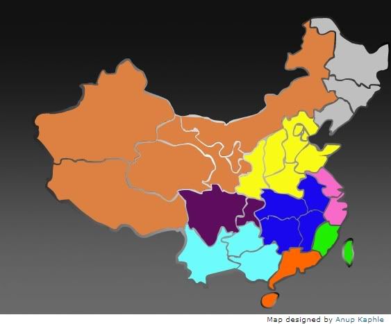
Chovanec, inspired by Joel Garreau's Nine Nations of North America, sees China as "a mosaic of several distinct regions, each with its own resources, dynamics, and historical character," and notes that "taken individually, these 'nations' would account for eight of the 20 most populous countries in the world." The nine regions are:
The Frontier (colored salmonish on the map): Population a mere 86 million. It's China's outback, or more pertinently, its Empty Quarter. Lots of wild landscapes, ethnic minorities, and exploitable resources - a milieu Americans might find faintly familiar!
The Refuge (contemplative purple): Pop. 110 million. An agricultural breadbasket consisting of the provinces of Sichuan and Chongqing, it's remote but close to self-sufficient; sheltered by high mountains, the be-pandaed region sounds like a Chinese pastoral idyll, albeit one that's now lurching somewhat gawkily into industrialization and increasing integration with the rest of China and the world.
Shangri-La (ethereal light blue): Pop. 132 million. Purported home of the legendary paradise on earth, Shangri-La is, naturally, beset by environmental degradation, drug cultivation (an historic producer of opium and, more recently, the far deadlier tobacco), and poverty: it's the poorest of the nine regions. It's also comprised of about 30% non-Han minorities.
The Yellow Land (a very yellowy yellow): Pop. 359 million. A massively fertile land watered by the Yellow River, this region has more people than the United States. It has also served as the center of Chinese political power since roughly forever; it's the real belly of the whatnot.
The Crossroads (sullen dark blue): Pop. 226 million. So named because of its geographical centrality, and because it has historically stood between regions that compete for its resources; the region's never risen to a position of dominance within China, despite its placement on the Yangtze and main transportation corridors of the country.
The Back Door (debauched orange): Pop. 112 million. Once known as Yueh, this region in the south of China was a sort of Wild South for northern elites: a place of exile, full of jungles, gambling, smuggling, shadowy secret societies, and monkey-eating. Anchored by Hong Kong, it's boomed on the back of massive exports of late; presumably becoming less awesome.
The Straits (green like money): Pop. a paltry 59 million. Formed by Fujian on the mainland and the ever-ambiguous Taiwan, the region has been primarily a sea-faring one for centuries; its colonies throughout southeast Asia still remain tied together in many ways. The Asian tiger-dom of Taiwan has driven this to become the wealthiest of China's regions, though its political future is anyone's guess.
The Metropolis (tawdry pink): Pop. 147 million. The area around Shanghai and the mouth of the Yangtze has been the one region to seize preeminence from the Yellow Land at various points in Chinese history. After a period of neglect during the years of High Communism in China, Shanghai has led the country towards what seems to be its ever more urbane, cosmopolitan, and capitalistic future.
The Rust Belt (industrial alienation gray): Pop. 109 million. This is Manchuria, the locus of a certain prickliness between Russia and Japan a century ago. Japan held the region from 1931 until World War II; it went quickly to the Communists, and it became a stronghold of the socialist state. The reform era, though, hasn't been kind to the region; parts are almost as bad off as Michigan, if you can believe it. Pastimes include grain alcohol, decline.
RedAlert
Love one another
I wouldn't necessarily call all of the colonies "occupied" territories.
While not really untrue in a sense, I agree the concepts can be distinguished from each other. I would have, but I didn't want the legend to be too verbose. But good call.
PiMan
Deity
Here is a map of the true red and blue states, based on every measure of classification found in the red/blue states wiki article combined.
1) Elected the same party in the electoral college in all four of the most recent presidential elections
2) Average margin of victory in the presidential election is above 5% for the same party over the last five presidential elections.
3) Both current senators are from the same party
4) Same party holds the U.S. state legislative upper house and lower house majority (Nebraska's unicamberal system is irrelevant because is fails a different criteria)
5) Same party hold the governor office
6) Same party holds at least 60% of the house of representatives from its state
7) Same party is listed in the "Current classification" section at the bottom of the article.

Blue states: Washington, Oregon,Minnesota, Wisconsin, Illinois, New York, Maryland, New Jersey, Massachusetts, Rhode Island
Red states: Utah, Texas, South Carolina
1) Elected the same party in the electoral college in all four of the most recent presidential elections
2) Average margin of victory in the presidential election is above 5% for the same party over the last five presidential elections.
3) Both current senators are from the same party
4) Same party holds the U.S. state legislative upper house and lower house majority (Nebraska's unicamberal system is irrelevant because is fails a different criteria)
5) Same party hold the governor office
6) Same party holds at least 60% of the house of representatives from its state
7) Same party is listed in the "Current classification" section at the bottom of the article.
Blue states: Washington, Oregon,
Red states: Utah, Texas, South Carolina
- Status
- Not open for further replies.
Similar threads
- Replies
- 564
- Views
- 30K
- Replies
- 4
- Views
- 685
- Replies
- 64
- Views
- 7K