Originally posted by Peri
Proposal 2 conforms to the poll result then by your own admission.
True, but I was pointing out that provinces of 8-9 cities would be preferable to all provinces having 7 cities. While this would technically fall within the bracket, 7 is a minimum, to be treated as a minimum.
Originally posted by Peri
Since the only real difference between the 2 proposals is the number of provinces defined
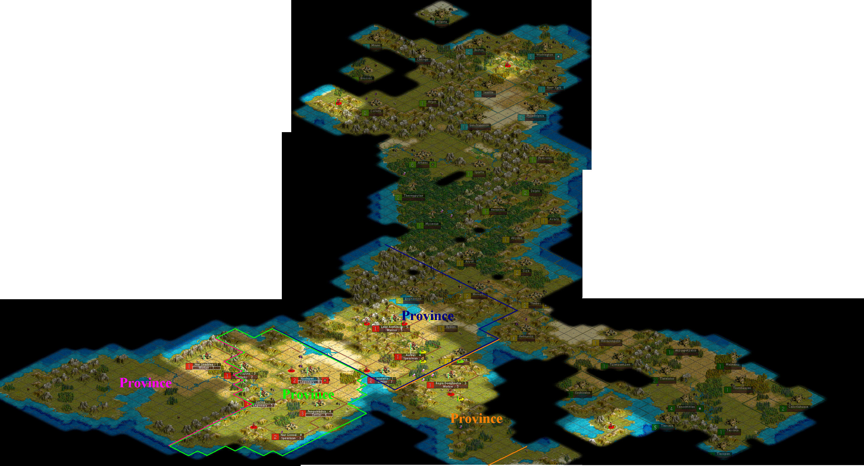
The main difference between these proposals is the situation of the Capitoline/2D4/OldE border and the corresponding far border of 'Old E'. The
second difference is that of the number of provinces defined (or rather the area they cover). If I may take each in turn.
i) Proposal 1 allows the Capitoline northern border to extend beyond the 'landbridge' and on to the plain on the other side. It then terminates at the foothills of the mountains. Correspondingly the near and far borders of 'Old Egypt' are moved eastward. This means that the majority of the area currently held by Cleo falls into 'Old Egypt'. This make Capitoline a stronger province, but also improves 'OE', as in the first proposal it will have some fertile lands in addition to large tracts of mountains.
ii) The reason I am attemping to define provinces in advance is this: we are at war with Egypt, and we are superior to them. It is very likely that, if we choose to do so, we could take most if not all of its cities. This we should have a provincial map drawn up to take in those conquered territories, so administration can be quickly implemented. I have devised a plan that accounts for all egyptian cities bar one (Heliopolis and the sothern regions are too little known to accurately map at this time.)
You all ask 'why mark out provinces in advance?'. I say to you, why not? When we think of where to draw our borders we must think ahead to the impact this will have on the next province, and the next. If you examine proposal one, you will see that it allows for logical and asthetic expantion under a good provincial structure!!!

") ) and a choice between AJ's blue province and one that stops at the landbridge. After this is determined by vote, we can(quickly) assess the possibilities for Old Egypt, and put that to vote as well.
) and a choice between AJ's blue province and one that stops at the landbridge. After this is determined by vote, we can(quickly) assess the possibilities for Old Egypt, and put that to vote as well.