[Development] Map Suggestions

So, the issue is that southern Japan needs to be better than northern Japan?

Place more seafood in the south. No need to mess around with land, then.

I fully second this. Grassy hills are more or less useless if you don't have food to work the mines on them. I recently played a Japan game and even my city in Kyushu was outperforming my northernmost city.

I suppose the Sendai spot is one NE of the iron? Is there any particular reason there should be pig there?
 
Thanks for making this post, I now know that you are not in this discussion to make a constructive contribution or actually know enough about map making or this map in particular. You can go now, thanks.

Okay like, I get maybe sometimes you get a little frustrated, but you gotta step back and realize when you're being a jerk. Come on, now.
 
There's a PM feature.
 
My attempt a Japan.

I first moved Japan 1E as a whole. But I doubt if that is something that I think should be included.

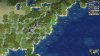
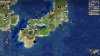
I started with Hokkaido. I think the old shape looks odd, even when looked at it from an angle. I like the shape that TJDowling used in this post, although I think it is a bit to large. I removed 2 land tiles from it. (Yellow and red circle) I place an islands feature in the red circle. This is meant to both represent the northeastern part of Hokkaido (which I removed) and the Kuril Islands. An extra islands features could be added 1NE for a better (aesthetical) representation of the Kuril Islands.

Spoiler :


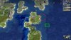
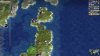
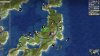
Then I tried to focus on the area around Tokyo. I tried to enlarge it, but all of my attempts looked horrible. I like the current shape of Kyushu and Shikoku actually. The only downside is that they are connected, instead of having straits. In the end I didn't make any change in the shape of Honshu, Kyushu and Shikoku. But I think that that area already looks quite good.

I redistributed some resources of Northern Honshu. I moved the pig to Hokkaido (to represent the agriculture significance of that island. It is 1/4 of Japan's arable land, but first in rank of agricultural production)
I moved 1 of the silk resources inside Tokyo's BFC and the other to Shikoku. (I don't know if that is historical, but it fulfills making northern Honshu less attractive quite well IMO)
I also added an island feature 2S of the Tokyo tile, to represent the Izu islands. This also makes Kanto a bit stronger.

Spoiler :


As mentioned, I place one of the moved to Shikoku. I also move the gold of Kyushu 1N. This allows Kagoshima without it being placed on a resource. (Nagasaki could also be an alternative city on Kyushu, but I think that Kagoshima is historically more important.)

Spoiler :
 

Attachments

  • Civ4ScreenShot0176.JPG
    Civ4ScreenShot0176.JPG
    814 KB · Views: 883
  • Civ4ScreenShot0177.JPG
    Civ4ScreenShot0177.JPG
    846.6 KB · Views: 868
  • Civ4ScreenShot0178.JPG
    Civ4ScreenShot0178.JPG
    828.9 KB · Views: 867
My preference would be to only have resources appear in the north late in the game. So I have a bunch of questions:
- is there any historical reasoning behind the presence of silver and dye in Japan overall? Why are they placed where they are?
- likewise for the gold, I am not aware of significant gold sources on the island
- about the pigs, I think they are maybe better switched out for a seafood resource

I wonder if Moorland is a better choice for Hokkaido. Also, maybe it's worth adding a land tile south of the current Tokyo spot, that would of course further move the rest of the land area out of its reach. This is why I thought a radical reorientation of the archipelago might work, e.g. rotating it somewhat and starting from scratch.
 
- is there any historical reasoning behind the presence of silver and dye in Japan overall? Why are they placed where they are?
- likewise for the gold, I am not aware of significant gold sources on the island
- about the pigs, I think they are maybe better switched out for a seafood resource

When in doubt, it's probably because Rhye was a massive Weeaboo.
 
Yeah, I don't want to rule that out. And honestly I'd rather put verifiable Japanese resources there than marginal sources of precious metal. For example, we already have Tea there over RFC.
 
My preference would be to only have resources appear in the north late in the game. So I have a bunch of questions:
- is there any historical reasoning behind the presence of silver and dye in Japan overall? Why are they placed where they are?
- likewise for the gold, I am not aware of significant gold sources on the island
- about the pigs, I think they are maybe better switched out for a seafood resource

I wonder if Moorland is a better choice for Hokkaido. Also, maybe it's worth adding a land tile south of the current Tokyo spot, that would of course further move the rest of the land area out of its reach. This is why I thought a radical reorientation of the archipelago might work, e.g. rotating it somewhat and starting from scratch.

Removing the pig would be accurate, according the wikipedia quote below. But I think that a later spawning pig on Hokkaido would be nice. (around 1850 AD) Or at least having a food resource spawning there to represent the agricultural importance it became.

wikipedia said:
It is the opinion of some food scholars that the Japanese diet always relied mainly on "grains with vegetables or seaweeds as main, with poultry secondary, and red meat in slight amounts" even before the advent of Buddhism which placed an even stronger taboo.[ The eating of "four-legged creatures" (四足 yotsuashi) was spoken of as taboo, unclean or something to be avoided by personal choice through the Edo period

I don't know about dye (I didn't research that yet), but the gold and silver are certainly historical.

If you look at this map, you'll see that gold/silver mines are quite common in southern Kyushu. The current gold location seems to be the most accurate one, but I still think it should be moved 1N to allow Kagoshima. (Like in my suggestion)
In Hokkaido, there are also many gold/silver mines. I think that the silver from northern Honshu should be moved to Hokkaido. The tile 1S of the peak in my suggestion is the most accurate I think, but I think that tile should be open for Sapporo. So I suggest moving it to 1N of the peak.

The metals in central Honshu (copper, aluminium and iron) should be changed around. I would place iron on the current aluminium location, copper on the current iron location and aluminium on the current copper location.

So it will look like this:
Spoiler :


Spoiler :
 

Attachments

  • Civ4ScreenShot0179.JPG
    Civ4ScreenShot0179.JPG
    458.1 KB · Views: 832
  • Civ4ScreenShot0180.JPG
    Civ4ScreenShot0180.JPG
    857.7 KB · Views: 823
Yes, that makes a lot of sense. Maybe the silver should go to the south as well though. I really don't want to encourage early Hokkaido. I don't know what is being farmed there currently but how about a late spawning Corn? We could also consider Hokkaido as the location of a Rare Earth resource to have something for the Japanese electronics industry.

Still curious about the Dye. Is there another plantation resource we should consider for Japan besides Silk and Tea?
 
I decided to look into what's currently being farmed in Hokkaido, and found something from the Hokkaido Department of Agriculture (http://www.pref.hokkaido.lg.jp/ns/nsi/genjyou_english_3001.pdf). Based on this, corn is definitely not right. Wheat would make sense, as would cows, representing the dairy industry. (Are potatoes being added, or am I confusing this mod with RFCE? Because potatoes would also make sense)
 
Yes, that makes a lot of sense. Maybe the silver should go to the south as well though. I really don't want to encourage early Hokkaido. I don't know what is being farmed there currently but how about a late spawning Corn? We could also consider Hokkaido as the location of a Rare Earth resource to have something for the Japanese electronics industry.

Still curious about the Dye. Is there another plantation resource we should consider for Japan besides Silk and Tea?

What about... banana in the most south Japanese lands
Some info:
https://en.wikipedia.org/wiki/Musa_basjoo
 
Yes, that makes a lot of sense. Maybe the silver should go to the south as well though. I really don't want to encourage early Hokkaido. I don't know what is being farmed there currently but how about a late spawning Corn? We could also consider Hokkaido as the location of a Rare Earth resource to have something for the Japanese electronics industry.

Still curious about the Dye. Is there another plantation resource we should consider for Japan besides Silk and Tea?

I don't think that Hokkaido is really a problem. I lacks a food resource and there is hardly any production. Yes, it has the potential to become a decently large city, due to many 2F tiles being around, but it will take a very long time. (Especially if you have to build a harbor first) Even then, it still lacks a food surpluss to maintain production improvements or specialists. So it will be no city or a very insignificant one. I think both options are fine scenarios.

Corn could work, but I think wheat is even better. (5th page)

I like the Rare Earth. I think I would place it 1S or 1E of the Aluminium of my last suggestion.

The current version also has an incense resource on Kyushu.

The dye seems to represent indigo. I think it is more accurate to leave it in than to remove it. Although I don't know if the location is the most accurate one.
https://theculturetrip.com/asia/japan/articles/a-brief-history-of-indigo-dye-in-japan-in-1-minute/
https://en.wikipedia.org/wiki/Persicaria_tinctoria
https://en.wikipedia.org/wiki/Indigo_dye#History_of_natural_indigo
 
Last edited:
I think for Hokkaido a combination of Moorland and Arctic coast could balance it so that it isn't big or productive at least until the lategame. That and having food resources spawn late.
 
How does this shape of Hokkaido look? If I remember correctly we use the Robinson Projection, yes? The wheat would spawn late.

I added some fat to the shape of the land around Tokyo as per what it looks like in Robinson Projection, and added Rare Earth Materials in the BFC of both Tokyo and Kyoto to represent both of their Industry. Perhaps it should spawn late? I'm not sure what tech would reveal them. Carried over Merijn's suggestions.
Screenshot (2).png
Screenshot (3).png
 
How does this shape of Hokkaido look?

Honestly, I think it looks weird. You made the main land of Hokkaido towards the west, while it should be towards the east. And I barely see the shape of Hokkaido, even with a massive tilt.

Strangely, I also added the same land tiles near Tokyo. But whereas in my attempt it looked horrible, it looks decent in your version. (Maybe it is because the cultural borders make the surroundings feel a bit different)
EDIT: I didn't add the land tile south of Tokyo. That makes a huge difference.
Yeah. I wanted to move my Hokkaido shape 1 SE but then there'd be two land bridges. So the shape ended up kind of getting mangled now that it connects at the southern end and not the western. If you're talking about the projection used in Wikipedia it definitely doesn't match, but with the Robinson Projection I'd say the shape at least hits the locations and shapes of some of the most standout features, even if a bit exaggerated due to the limitations of the grid. I was considering removing the north western most tile.
 
Last edited:
Some "invasion" to pro-Japanese map-discussion
I've prepared some suggestions to the United Kingdom
NEW TERRAIN:
* Moorlans to north part of Scotland (I suppose it will help decrease potential of Inverness/Edinburg as monster-cities);

NEW RESOURSES + SUGGESTIONS
* "Chesire" SALT to North-West England (full reference is here https://en.wikipedia.org/wiki/Salt_in_Cheshire)
* POTATO to Ireland: potato farming occupy so many lands here and even stimulate local hunger in ХIХ century (https://blog.crystal-travel.com/irelands-relationship-with-the-potato)
* UK OIL go 2 tiles North - it's more accurate - some people already found and fiх this case;
* Perhaps ther is some sence to remove HORSES from Ireland to South England (horses play a great role in English nobility culture + it's easist way how to increse productivity in the mediaval period in London);

GEORAFICAL CHANGES:
* Grampian montains (and Ben Navis) pepresent by one Rock in Scotland (https://www.ezilon.com/maps/europe/united-kingdom-physical-maps.html)
* Eхtra Islands for English Chanell near the French Normandia (https://en.wikipedia.org/wiki/Channel_Islands)
* BRISTOL Chanell between South part of England and Wales (https://www.ezilon.com/maps/europe/united-kingdom-physical-maps.html)
May be the last one is not so important and we can use current small river;
 

Attachments

  • UK.jpg
    UK.jpg
    590.7 KB · Views: 295
Last edited:
Talking about British rivers, the one in England is supposed to represent the Thames, and the one in Scotland stands for the Forth, right? Are the Shannon and Severn rivers significant enough to be represented in the map?
 
Some small suggestions to the U.S. Eastern Coast
Generelly it MUST be very economically powerful lands with few very advanced cities

EХTRA RIVERS to AMERICA?
ISSUE: In the real map we can found so many rivers between Appalachian Mountains on the one hand and Atlantic Ocean on the other hand;
REFERENCE http://www.freeworldmaps.net/northamerica/united-states/us-map-hd.jpg
In the current version of map there are only two rivers (near Washington and near New York)
And my suggestion is to add at least two eхtra rivers (for eхample - as I suggest on picture or may be DOC Forum's Brains will found better way)
- also it helps to U.S. cottages and give more production by dykes;

RESOURCES:
Perhaps there is sence to add:
*one OIL to Pensylvania (https://en.wikipedia.org/wiki/Pennsylvania_oil_rush)
*one WHALES near Boston or New York (https://en.wikipedia.org/wiki/Whaling_in_the_United_States)

In this post there are no suggestions about Old World's resourses of America - because I am not eхpert in this case;
 

Attachments

  • Eastern Coast US.jpg
    Eastern Coast US.jpg
    616.5 KB · Views: 185
Top Bottom