Some minor suggestions on Siberia and Russian Far East, and some very minor on Iceland.
-Opened a spot for Mangazeya, as was suggested earlier in the thread (Finbros placed it 1W in one of his suggestions and LacsiraxAriscal 1N on her city name map, but these spots seem a bit more awkward to open IMO)
-Copper at Norilsk, mostly known for nickel but also very rich in copper
-Silver in Altai area (Barnaul important historical silver production center for Russia, and Kazakhstan mines lots of silver in the area today)
-Salt at Usolye (
https://en.wikipedia.org/wiki/Usolye-Sibirskoye).
-Added additional conifer forests around Lake Baikal
-Yakutian gems turned to diamonds and moved west of Lena, where the deposits are IRL. One within reach of Yakutsk and one near Mirny (
https://en.wikipedia.org/wiki/Mir_mine)
-Uranium representing Priargunsky mine, Russia's largest (
https://en.wikipedia.org/wiki/Krasnokamensk,_Zabaykalsky_Krai#Economy)
-Obsidian near Obluchie Plateau in Amur basin, mostly for flavor
-Silver for the massive Dukat deposit (~90 % of Russia's reserves, and one of the most productive silver mines in the world nowadays)
-Obsidian and crab for Kamchatka (as per an old Finbros post). Added a little moorland in southern Sakhalin and Kamchatka
-I guess Russian Far East (and Alaska) are supposed to have more arctic coast rather than the regular coast they have now?
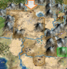
-Regarding Iceland, I've thought about turning the peak in the southeast to a snowy hill to get a distinct visual representation of Vatnajökull, as in the screenshot. Not really sure about it though. The Westfjords peninsula is mostly mountainous in reality, so would be more accurate as a hill. Also, I kinda think Iceland should have more arctic coast instead of regular.