[Development] Map Suggestions

The Final Frontier Plus mod has a similar mechanic, to create 'starbases' that function somewhat like forts (easier to defend) and somewhat like cities (1-culture claim on all tiles immediately around the starbase. I'm a huge fan of doing something similar in Dawn of Civilization for colonies, albeit it with an additional mechanism for turning such colonies into real functioning cities.
We discussed something similar in suggestions I think, where you might be able to settle colonies in Sub-Saharan Africa and the Caribbean to get resources/trading company corporation, with the benefit of lower maintenance and the cost of less production. What you're proposing would be very similar and work well alongside it.
Another example is the Civ 5 Portuguese Fetoria, which is a improvement that can be built in allied city states to get luxury resources. Imo it's actually super cool and one of the few things that Civ 5 does really quite interestingly. Something like that might be interesting, even if only limited to a single civ as a UP.
 
This is great, thanks. Thinking about North American resources, I think there should also be iron (coal?) near Birmingham, Alabama. And I think the current Great Lakes distribution oversells copper and undersells iron in Minnesota.

Here is some information about Iron in the US: https://en.wikipedia.org/wiki/Iron_mining_in_the_United_States

"Most US iron mining before 1850 took place in eastern Pennsylvania, New York, and northern New Jersey.[9] New Jersey's principal iron ore district, at Randolph, began mining in 1710. The Cornwall iron mine, the largest iron-producer in Pennsylvania, began mining in 1740. The Adirondack district of New York began mining in 1775."

"Iron ore was discovered on the Marquette Range in 1844, and mining started in 1848. Mining increased after the opening of the ship canal at Sault Ste. Marie provided cheap water transportation between the iron mines to the lower Great Lakes. The Lake Superior iron deposits were the largest ever discovered in the United States, and by the late 1800s, dominated American iron mining.

The Lake Superior iron ores occur in Precambrian banded iron formation, in long, linear belts called iron ranges. After the Marquette Range in Michigan, iron ore was discovered in the Menominee Range (Michigan) in 1867, the Gogebic Range (Michigan and Wisconsin) in 1884, Vermilion Range (Minnesota) in 1885, Mesabi Range (Minnesota) in 1890, and the Cuyuna Range (Minnesota) in 1903."

"The largest production of US iron ore outside the Great Lakes districts was the Birmingham, Alabama district."

I don't know if there is a prototype available for the new map, so I will just make recommendations based on the current map that comes with the 1.16 download.

I would recommend removing the current iron from the Appalacian mountains and adding one iron each to Alabama and Minnesota. Depending on how many irons you want to have, additional sources could be added in Pennsylvania/New York and Wisconsin/Michigan.

During the World War Era, the US produced 30%-50% of the world's iron. So, it was a lot, but it was also a short time period under extreme conditions. Not sure if it's worthwhile enough to give the US so much iron that they can export a bunch. Also, the Minnesota iron source became depleted after the wars. Not sure if it's worth it to represent that or not.

Thanks!
So: let's try to UNITE your suggestions and other ones

1. NJ and Pensilvania copper's ore
2. Local Iron (perhaps we can use any tile in Westen part of this land)
3. Push old iron to number 4
4. New location of iron (Cuyuna Range // Vermilion Range etc)
5. Tenesse' copper (biggest in US South)
6. Old copper (we currently have it)
7. Alabama's iron (it's Alabama' land - am I right?)
 

Attachments

  • Mines.png
    Mines.png
    3.6 MB · Views: 249
  • upload_2020-8-6_6-45-47.png
    upload_2020-8-6_6-45-47.png
    6 MB · Views: 244
Let's speak about Ukraine

On the one hand: I really like current version // but on the same time: there are a few minor-suggestions

1. Konotipyan Marshes - iconic land in the local historical literature. There was a a lot of ex-cossaks and even witches in the period between 1500-1800;

2. More accurate Slobodan's Area (Eastern Ukraine): more hills (which hive opportunity represent this land a little bit realistic);

3. Push Krivoi-Roh: de-facto iron-heart of Urkaine (1790-current time);

4. Azov (Donbass) coal: south-eastern part of Ukraine was the biggest producer of coal in Russian Empire/USSR/Post-Soviet States. We already have this coal in the old map.

5. Bukovina' meat - main reason why I suggest push pig (1 tile south) - to decrease growth of Kiev and also give arguments buit sity in the Western part of Ukraine

6. Zhitomyr and Rovno - non-productive lands near the Poland (perhaps regular plains - is the best way how to pepresent them);

7. Kameneck-Podolsky: one of the oldest (and biggest) source of stone in this area;

8. Land of South-Chernozem: it will be much more accurate if we push wheat one (or even 2) tiles to south.

9. Russian iron go to north - in this tile it will represent not only Kursk' deposits but also Tula' mettalurgy
 

Attachments

  • New Ukraine.png
    New Ukraine.png
    3.2 MB · Views: 303
Few minutes ago - I've found really advanced physiacal map of the United States
Perhaps it will help everyone who want to make minor-suggestions for AMERICA :cool:
 

Attachments

  • map of the America.jpg
    map of the America.jpg
    1,016.8 KB · Views: 226
Geek-Mode activation!
Let's speak about Ural and Upper Volga' Area: there are some suggestions which make this lands a little bit more accurate

1. Salavat's oil deposit (and also bashkyrian Ishinbai) - in the long period (from 1926) it is the biggest oil-deposit in the European part of Russia
There is even some popular songs about brave oil-workers in Salavat-Ishinbai which describe riches of local oil and oil-industry workers;
Oil-Market brand "URALS" also based on local oil location;

2. Upper Volga - it is land of a lot of russian and tatarian small and big sities and there is huge contrast between more or less urban Upper Volga and lonely steppes near the Caspian Sea:
So: I propose a few grasslands hills and also one Cow near Saransk/Syzran' (which reflect local peasants' agrarian potential)

3. Small pro-geografical recomositon of PERM's area resourses and also I add one coal whcih represent so called Kyzelbas' deposit near Gubaha (1787-2002)

4. Delete local stone and propose gold as alternative one: it reflect Potemkin's Mining which appeared in the South Ural in the Peter the Great' Era;

5. Ural's Valley Taiga: big unurbanized area - there are nothing except wild animals and few lumbermills

6. Glasov' Deers - I think Perm need a l least one resoursce for growth

7. Plain tiles for South Bashkyria which describe for example Orenburg' area and natural-border between mountains and steppes;
 

Attachments

  • Volga and Ural.png
    Volga and Ural.png
    3.3 MB · Views: 252
Last edited:
Final wave of suggestions here:
Spoiler America :

ca.png

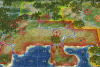
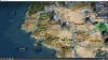
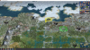
-Added semi desert north of LA
This land isn't really great for growing anything. Mostly retirees and golf courses.
-Added two plains north and east of San Francisco, made SF a hill
This area is more of a Mediterranean climate.
-Oranges and citrus spawn in Arizona and San Diego in 1700. Wine spawns north of San Francisco
The Spanish missions that settled California brought citrus and wine, but California itself was considered of little importance. Citrus on the SD tile also can service Tijuana. Mexico should get at least two other citrus sources in the south east and west given how much lemons and limes they produce and how important they are to their cuisine (rice too for the same reasons).
-Gold and cows spawn 1800
The California gold rush was in the mid 1800s but it should spawn early to give the US (or Mexico/Canada) ample time to grow. Cow spawns in Fresno as livestock was brought by settlers and it is a huge industry today.
-Shrimp, dates, olives and rice spawn in 1850, Central Valley tiles become floodplains
The Central Valley is a massive breadbasket the enormous populations California's major cities can be represented by the addition of floodplains here. Rice and olives are fitting as they are just some of the foods produced here. The Coachella Valley, east of LA, produces close to 90% of dates in the US. Two sources of shrimp for each city given how important pacific shrimp is to the state. Also allows for spread of sushi industry, for anyone who as ever been to CA, this fits rather well. SF shrimp fishing started in 1869 so I think 1850 is an appropriate spawn date.
We could also have the dates and shrimp in Southern California spawn later to represent its explosion of growth since the 1950s with water pumping from the Colorado.
-Added oil offshore from LA
It really should be one tile north as there are large reserves here and California shouldn't be left without oil.
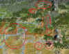
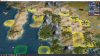
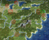
wa.png

NW
-Moved deer off of Portland tile to east of Seattle
Hunting is really a viable resource in any of the northwestern forests, this tile should probably also be a hill.
-Made eastern Oregon/southern Idaho tiles into plains, added semidesert to the hill west of the salt lake.
Better represents the transitioning landscapes.
-Added potatoes to Idaho
Idaho is a huge potato producer, they're famous for it. Go to any supermarket in the US and you are sure to find "Idaho Potatoes." Also provides food for a Salt Lake City.
-Cows spawn 1800 north of Portland
The area north west from Portland is a huge dairy producer. Spawn date approximates migration of people the the north west so it also represents early livestock.
-Horse spawn 1800 in Idaho/Western Washington
This area is home to some large American Indian reservations and has an old tradition of breaking and training wild horses. I think Portland/Seattle could use the production bonus.
-Replaced fish with shrimp and moved them closer to Vancouver
May encourage a placement of Vancouver further north, also provides Canada a source of shrimp which they should have.
-Added islands NW of Seattle, moved fish west
Approximates the many islands of the Puget Sound.
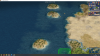
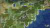
wc.png

Carib
-Added marsh to Florida Panhandle/Southern Georgia
Florida needs to be swampier and this area is still underdeveloped today.
-Added marshes to central Florida and rainforest to south Florida
The marshes clear in 1800 for Tampa and Florida oranges (its on the license plate).
-Added citrus to southern Florida in 1700
represents the importance of lime production in the Florida Keys, also general citrus production in Southern Florida.
-Upper Cuba is savanna and less densely vegetated while lower Cuba is wetter and more dense.
This reflects the terrain and development of the island.
-Added iron and jungle to eastern Cuba, banana spawns in 1700
Cuba's early development was based almost entirely on sugar production I think banana should be added in 1700 to represent plantains and add to Havana's food pool as Cuba is the most populous of the Carib islands.
-Added crab south of Jamaica
Allows for greater population and accounts for importance of shellfish
-Sugar spawns on Bahamas and Jamaica in 1650
The primary early crop of the Caribbean, should be abundant and available for plenty of European powers given its prevalence.

ec.png

-Expanded size of Hispaniola by removing eastern tile and adding three southern tiles
Of all of the potential expansions, this one fits the best and also makes the most sense. The middle two tiles are jungle hills because of their current lack of development and also to prevent city founding so both Haiti and DR are open. The northern Haiti tile is rainforest as it actually used to be quite forested while the south is more sparse, both are hills.
-Added fish, coffee and sugar to Haiti
Coffee spawns later as it was introduced later.
-Added gold and sugar to DR, moved clams off coast
Gold was one of the primary reason Spain was drawn to early colonization of Hispaniola. I think bananas might also be worth adding to the easternmost tile to represent plantains for the same reasons I put them on Cuba.
-Added citrus to Puerto Rico 1650, moved islands south to fit chain, added crab off coast
Puerto Rico grew a number of cash crops. I went with citrus given sugar being so prevalent (and more relevant on other islands). Coffee could also work here. The crab adds population just as with Jamaica.
-Nutmeg on Grenada
I think this one is already planned, we could remove the crab given that the Grenadines are less populated compared to Jamaica or PR.
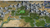
co.png

Colombia
-Added floodplain with potatoes on Magdalena
Could also be Rice, both are important to the cuisine and economy.
-Made all mountains and highland llano regions savanna terrain, removed rainforests
The Colombian highlands (llanos) are not densely forested. Perhaps the gold tile should also be savanna.
-Added semidesert north of Maracaibo
This is an arid region, at best it should be plains, certainly not rainforest. Maybe put a floodplain on it to represent the transition of vegetation/more food for Maracaibo/Barranquilla.
Also I don't know if any of these peaks change to hills but Colombia has no room for coffee. They should get at least two of them as they are a huge producer of it. Also, perhaps the nw marsh could be a jungle to re-add chocolate.

ny.png

New York
Thanks to recent contributions, I think this is how the production resources should play out:
-Iron, coal and copper added west of NY
All three were important in the development of NYC, all three are also abundant in south-central NY/northeastern PA.
-Added cow 2n of NY in 1700
Also workable by Boston, this area of western Mass/southern Vermont is rich in dairy.


Not pictured - Falkland oil should be added offshore.


I worked with the settler/city naming maps while trying to bring the new terrains/features into the old map. I'm happy to update them with the new map although I understand the code might be completely revised, yes? Let me know if I can add anything. I'll have my final suggestions for Europe/Asia/Africa/Australia out soon.
 

Attachments

  • ca.png
    ca.png
    4.9 MB · Views: 111
  • ca.png
    ca.png
    3.9 MB · Views: 107
There is a whole thread for city names.
 
I mean at the code level.
The existing system from city manager.py is something like:
-1, -1, -1, -1, -1, -1, -1, -1, -1, -1, -1, -1, -1, -1, -1, -1,
-1, -1, -1, -1, example, example 2, -1, -1, -1, -1, example 3, -1, -1, -1, -1,
-1, -1, -1, example 5, -1, -1, -1, -1, -1, -1, -1, -1, -1, -1, example 4, -1, -1, -1, -1,
-1, -1, -1, -1, -1, -1, -1, -1, -1, -1, -1, -1, -1, -1, -1, -1, -1, -1, -1, -1, -1, -1,

I was wondering if you were going to re-work that system, I noticed the map develop code was different than the old code.
 
The thread describes what the plan is.
 

mx.png

I think the terrain is the same, I may have added semidesert to the Rio Grande
-Shrimp instead of crab on Pacific coast
More variety in Mexican seafood.
-Added savanna trees to Cabo San Lucas
The bottom area is more vegetated, similar in climate to Southern California.
-Cochineal moved to deserts (Baja California/Queretaro)
Cochineal bugs attach to cacti to feed off of their moisture, they are common in desert environments, hence moving them to deserts.
-Added silver north of Mexico City
Mining was the main economy of early Mexico and Mexican silver can be argued to be the first global currency. Mexico should get multiple sources and the biggest mines were in Queretaro.
-Cotton spawns 1750 in Sonora Desert
There was a cotton in Veracruz but I couldn't find anything on it. Mexican cotton production comes from these two areas in the north. I put 1750 as it blends these regions' time of settlement (1700s) along with Mexican textile production (1800s).
-Sheep/cow spawns 1700
The settlers of Mexico's northern interior brought sheep and cows with them, these are still big industries in these parts today.
-Iron and wheat spawn 1600
I think the iron is already scheduled to appear here, it was the top producing region since the Spanish conquest. I mulled over including rice but wheat is actually more historically relevant as it was one of the first crops the Spanish brought over and was largely farmed in the Baijio region. The wheat replaces the vanilla which maybe shouldn't exist at all. While vanilla comes from Mexico, it was never a mass producer of it.
-Horses spawn 1650 on the Rio Grande
Horses are naturally a huge part of Mexico's northern "vaquero" culture and needed for a UU.

cm.png

Highlighted tile is the Motagua river valley, this was the only location that Mesoamerican cultures could obtain Jade so I removed the other source.
-Citrus spawns 1650 in south eastern and western Mexico. These are the primary growing regions and citrus fruits are instrumental to Mexican cuisine.
-Changed three Yucutan tiles (and the eastern citrus tile) to jungle
These are all underdeveloped/nature preserve areas today, jungle will keep it that way.
-Removed Cancun corn and placed stone to the south.
The production of (especially Mayan) cities out here was rubbish in the old map. Given the use of stone in Mayan architecture (and Chichen Itza) there ought to be a source of it here.
-Added sugar to Veracruz in 1650
Sugar was another early crop the Spanish brought to Mexico and Mexico has been a large sugar producer ever since. The most significant area in sugar production is here in Veracruz.

I thought it was overkill but given the size of Mexico City today, perhaps a rice should spawn in 1850 on the tile west of Mexico City.
 

Attachments

  • mx.png
    mx.png
    3.6 MB · Views: 60
Cochineal production was actually restricted to the Oaxaca area for most of history, so it should occur there, not in the NW deserts.
 

View attachment 567506
I think the terrain is the same, I may have added semidesert to the Rio Grande
-Shrimp instead of crab on Pacific coast
More variety in Mexican seafood.
-Added savanna trees to Cabo San Lucas
The bottom area is more vegetated, similar in climate to Southern California.
-Cochineal moved to deserts (Baja California/Queretaro)
Cochineal bugs attach to cacti to feed off of their moisture, they are common in desert environments, hence moving them to deserts.
-Added silver north of Mexico City
Mining was the main economy of early Mexico and Mexican silver can be argued to be the first global currency. Mexico should get multiple sources and the biggest mines were in Queretaro.
-Cotton spawns 1750 in Sonora Desert
There was a cotton in Veracruz but I couldn't find anything on it. Mexican cotton production comes from these two areas in the north. I put 1750 as it blends these regions' time of settlement (1700s) along with Mexican textile production (1800s).
-Sheep/cow spawns 1700
The settlers of Mexico's northern interior brought sheep and cows with them, these are still big industries in these parts today.
-Iron and wheat spawn 1600
I think the iron is already scheduled to appear here, it was the top producing region since the Spanish conquest. I mulled over including rice but wheat is actually more historically relevant as it was one of the first crops the Spanish brought over and was largely farmed in the Baijio region. The wheat replaces the vanilla which maybe shouldn't exist at all. While vanilla comes from Mexico, it was never a mass producer of it.
-Horses spawn 1650 on the Rio Grande
Horses are naturally a huge part of Mexico's northern "vaquero" culture and needed for a UU.

View attachment 567505
Highlighted tile is the Motagua river valley, this was the only location that Mesoamerican cultures could obtain Jade so I removed the other source.
-Citrus spawns 1650 in south eastern and western Mexico. These are the primary growing regions and citrus fruits are instrumental to Mexican cuisine.
-Changed three Yucutan tiles (and the eastern citrus tile) to jungle
These are all underdeveloped/nature preserve areas today, jungle will keep it that way.
-Removed Cancun corn and placed stone to the south.
The production of (especially Mayan) cities out here was rubbish in the old map. Given the use of stone in Mayan architecture (and Chichen Itza) there ought to be a source of it here.
-Added sugar to Veracruz in 1650
Sugar was another early crop the Spanish brought to Mexico and Mexico has been a large sugar producer ever since. The most significant area in sugar production is here in Veracruz.

I thought it was overkill but given the size of Mexico City today, perhaps a rice should spawn in 1850 on the tile west of Mexico City.
I think you maybe might need to add an alcohol/bad decisions resource to Cabo. Just speaking from experience...
 

View attachment 567506
I think the terrain is the same, I may have added semidesert to the Rio Grande
-Shrimp instead of crab on Pacific coast
More variety in Mexican seafood.
-Added savanna trees to Cabo San Lucas
The bottom area is more vegetated, similar in climate to Southern California.
-Cochineal moved to deserts (Baja California/Queretaro)
Cochineal bugs attach to cacti to feed off of their moisture, they are common in desert environments, hence moving them to deserts.
-Added silver north of Mexico City
Mining was the main economy of early Mexico and Mexican silver can be argued to be the first global currency. Mexico should get multiple sources and the biggest mines were in Queretaro.
-Cotton spawns 1750 in Sonora Desert
There was a cotton in Veracruz but I couldn't find anything on it. Mexican cotton production comes from these two areas in the north. I put 1750 as it blends these regions' time of settlement (1700s) along with Mexican textile production (1800s).
-Sheep/cow spawns 1700
The settlers of Mexico's northern interior brought sheep and cows with them, these are still big industries in these parts today.
-Iron and wheat spawn 1600
I think the iron is already scheduled to appear here, it was the top producing region since the Spanish conquest. I mulled over including rice but wheat is actually more historically relevant as it was one of the first crops the Spanish brought over and was largely farmed in the Baijio region. The wheat replaces the vanilla which maybe shouldn't exist at all. While vanilla comes from Mexico, it was never a mass producer of it.
-Horses spawn 1650 on the Rio Grande
Horses are naturally a huge part of Mexico's northern "vaquero" culture and needed for a UU.

View attachment 567505
Highlighted tile is the Motagua river valley, this was the only location that Mesoamerican cultures could obtain Jade so I removed the other source.
-Citrus spawns 1650 in south eastern and western Mexico. These are the primary growing regions and citrus fruits are instrumental to Mexican cuisine.
-Changed three Yucutan tiles (and the eastern citrus tile) to jungle
These are all underdeveloped/nature preserve areas today, jungle will keep it that way.
-Removed Cancun corn and placed stone to the south.
The production of (especially Mayan) cities out here was rubbish in the old map. Given the use of stone in Mayan architecture (and Chichen Itza) there ought to be a source of it here.
-Added sugar to Veracruz in 1650
Sugar was another early crop the Spanish brought to Mexico and Mexico has been a large sugar producer ever since. The most significant area in sugar production is here in Veracruz.

I thought it was overkill but given the size of Mexico City today, perhaps a rice should spawn in 1850 on the tile west of Mexico City.

Awesome research and work! I have some comments about the resource proposals:
- (as Steb mentioned) Cochineal should be restricted to Oaxaca and at most southern Mexico (if there was a second location).
- I had originally proposed to have cotton in Veracruz, because that's where the plant is originally from: I mean, the place where it was domesticated. There are couple of different varieties of cotton in commercial use in the world today, but the mesoamerican one accounts for 90% of modern global production IIRC. You're right, it's not an important crop in that region anymore, but I think it was significant enough to have it there during the prehispanic period. Cotton was fundamental to the mesoamerican economy, so it kind of needs to be somewhere. For the later centuries, the last thing we agreed on this point was to eventually replace it with a different crop: bananas, citrus, coffee or cattle would be adequate for modern Veracruz. I agree to have it in northern Mexico during modern times, as you propose, although I'm not sure that very northern tile in Chihuahua would be the best place. Cotton requires a lot of water, which in that region can only be provided with the irrigation systems on the Sonoran coast.
- I had also proposed earlier to have iron not in Zacatecas (where you placed it) but in Nuevo Leon. The reason is that that's the main production center (even if that's not where the mines are) and the iron industry was a main driver of that city's (Monterrey's) industrialization.
- Horses would be more appropriate around the Bajio or Jalisco regions, but given how crowded that area is already, I'd suggest to go for a second best and have it in one of the coastal plains on the gulf side, either in Tamaulipas or Veracruz.
- Historically, the main silver mines were not in Queretaro, but next door in Guanajuato (which on the map is the same tile anyway), and also in Zacatecas (right where you placed the iron). I'd recommend to change the iron for silver, and move the iron northwest as mentioned in point above.
- Indeed, vanilla was there because that's where vanilla was domesticated. The actual site of origin is Veracruz (and right the spot of Veracruz city). During aztec and colonial times, it was an economically important product, whose production methods were kept secret. I recommend to keep it as it was during prehispanic and early colonial eras, I would agree to exchange it for another resource (same as with Veracruz cotton) in later centuries.

And clarification/counter-argument about the Mayas. The Yucatan area was actually highly settled during Mayan times, also the interior. The tropical forests were highly productive as the Mayans used a combination of what we could call today agroforestry techniques. The Mayans had a big hand in determining the current composition of tree and plant biodiversity in the rainforest, as the current proportion of plant species is skewed towards those with human uses for food or materials. I'd like to (very politely!) challenge the conception that this area was "underdeveloped" and that jungles should be the terrain type used in the Mayan areas. Much the opposite, there should be forests there enabling productive and healthy cities. Having said all that, it's true that after the mayan collapse, especially the classic collapse, cities were abandoned and the population density in the interior declined. In the post-classical era Mayan population concentrated in Northern Yucatan, all the coasts of the peninsula, and in the highlands of Chiapas & Guatemala. And yes, nowadays, the region is highly forested except for the coasts, so I would understand if for colonial and modern times, people would want to indeed replace some forests with jungles there.

edits: some words for clarification
 
Last edited:
Spoiler Africa :

ws.png

-Added wine to Canary Islands
Should spawn in 1400 along with the sugar in Madeira. Castilian wine production was important here for trade with England.
-Changed Cape Verde to semi desert and added savanna trees
Most of the islands of Cape Verde are not completely barren, it should have a bit of vegetation.

ng.png

Made highlighted tile a rainforest, changed northern tiles to savanna trees
Better reflects the jungle density of the region.
-Added oil east of the Niger
There are a ton of oil fields in the Niger delta so its best represented with the existing offshore and adding another on land. Also helps late game production in Lagos.
-Added banana to Ghana
The gold coast has been a population dense area for most of history and Ghana is West Africa's largest producer of plantains. Chocolate should also be added after the Columbian exchange as the backbone of the Ashanti empire was primarily agriculture and trade of chocolate and gold.
-Added millet to inland Niger
Also could be further north-west. Millet was a very important crop to the region and still is today. After India and Nigeria, no country produces more of it than Niger.
-Added rubber to Nigeria
While Nigeria was never a rubber producer on the scale of India or Congo, they produce plenty of natural rubber. I think the historical source was in the Edo region so it should actually be placed one west of where I have it.
-Added potato north of Lagos
Hard to see it, the potato represents yams which were hugely important to the agriculture of the upper Niger and to Igbo culture in general.
-Added corn to upper Nigeria in 1900
Its a late spawn but Nigeria is now the most populous country in Africa, especially if a Nigerian civ is added, this ought to be reflected. Corn is widely grown and available in modern times and is also featured widely in modern cuisine.

cf.png

I want to start by pointing out that this region is usually the least interesting in civ games and often goes the entire game without settlement.
-Changed northern Cameroon/western CAR to savanna trees
While not very developed in today's times, these areas are not dense jungles either. Perhaps marshes could be considered but its not quite wet enough here.
-Added diamonds to CAR
CAR is rich in diamonds and significant deposits exist in the eastern part of the country.
-Added uranium and aluminium (might have already been there) to western CAR
Although one of the poorest countries in the world, CAR has plenty of mineral wealth, and has significant deposits of uranium and other modern metals. Cotton could also be added in the late 1800s as it was introduced as a cash crop by the French.
-Changed highlighted tile (Yaounde) to rainforest
Allows settlement. Also the tile east of the uranium (Bangui), should be rainforest as well.

cg.png

-Changed the tiles at the mouth of the Congo to jungle
Prevents city settlement.
-Reworked terrain, savanna placed for more of inland Congo basin out to highlighted tile
The Congo interior is wet and sparsely populated hence changing plains and grasslands.
-Added highlighted marsh
This would be a good city location except there are no major settlements on this side of the lake in real life. Jungle might be better than lake given the Congo UA, but I like to give a human player the option in this case.
-Rubber
Placed three in the Congo basin in hopes to spread out city placements.
-Coffee added to Rwanda. banana added to north west
Rwanda in one of the more populous and richer countries in Africa. Both Uganda, Rwanda and Burundi are heavily dependant on cash crops like coffee and agricultural production of fruits.
-Added banana east of Mbanza Kongo
The city needs a food source, I think banana as it is a huge sector of Congolese agriculture. Mbanza Kongo could also be placed a tile north and become Kinsasha/Brazzeville at various points in history.
-Added coal to south eastern Congo
There are huge coal and copper deposits in this area, we already have copper so I added coal.
-Added oil offshore from Congo
Congo has significant oilfields and this along with the iron feeds Pointe-Noire as an industrial hub in the late game as it should be.

et.png

-Reworked terrain in north eastern Ethiopia
I put a stretch of plains because this is a fairly dry area in real life and a better transition to the semidesert coast.
-Highlighted tile has been made a hill
Nairobi (1w) sits on a sort of plateau so either it should be hill or the tiles surrounding it should be.The more I look at it I think 1w ought to be a hill and the highlighted tile should remain flat.
-Highlighted lowland coffee
Unless for a specific reason, coffee ought to be placed on hill tiles as it grows best in higher altitude climates. There is a ton of coffee in this area so perhaps one could be removed.
 

Attachments

  • ws.png
    ws.png
    3.1 MB · Views: 97
Just a heads up, I will probably soon implement the next current batch of suggestions. So if there is something you wanted to make a post about but never got around to, now is the time if you want it to make it into that.
 
Spoiler Europe/Central Asia :

ad.png

-Added horses in Veneto
Veneto had prospered in the breeding of horses and trade of amber with the Etruscans and Greeks. Perhaps amber should be added to the clam tile and the clams move south one. Further Italy should have a horse resource and Venice could use the production.
-Added island feature on highlighted tile
Aligns better with Croatian coast.
-Stone added north west of Ragusa
Ragusa was an important city in many eras and is notable for its impressive walls. The production bonus also could help a Belgrade which could use a source of stone for all the same reasons.
-Swapped wine and olives in Greece
I don't know if there was a particular reason behind their placement but I figured the olives are better placed close to Kalmata which is famous for them. The wine in the north also plays in to many of the vineyards stretching up to Albania.

pk.png

Lahore is this tile, yes? The old map had it too far south.
-Added salt to the north
Famous Himalayan salt from the Punjab region. Legend associates its discovery to the armies of Alexander the Great.

tb.png

-Replaced tundra with semidesert
Compared to space maps, the Tibetan plateau is more accurately characterized with semidesert.
-Highlighted tile made a bamboo forest
Assam is loaded with bamboo forests. I was wondering if we should have more of them placed in India, I wasn't able to find much on it.

ru.png

-Added Siberian Jade
There are two others but the map is not attaching.

sb.png

-Placed diamonds on highlighted tile
Location of Mir mine, the largest diamond mine in the world. The open mine is so big it swallows helicopters, entire town is built around the mine, definitely worth a google search.
 

Attachments

  • pk.png
    pk.png
    3.7 MB · Views: 64
  • pk.png
    pk.png
    3.7 MB · Views: 98
  • ru.png
    ru.png
    3.7 MB · Views: 92
  • ru.png
    ru.png
    3.7 MB · Views: 48
  • ru.png
    ru.png
    3.7 MB · Views: 85
Top Bottom