Hi all, Civ4 lovers!!!!
65 millons of years ago I had an idea :
:
I have a lot of ancient Earth maps (10 millons of years ago, 50 millions, 65, 100, 150, 250, etc... with its contintents and references to the actual continents.
If you want, we can create Earth Ancient maps to be played in BTS, with its starting locations (for example, in Pangaea Map, Spain and USA would begin very close, incas will be next to zulues, and India will be and island....
Well, I´ll post here a few maps, I hope you´ll join to this project. We can do them in the same size, and join all in a unique pack called "Ancient Earth Ages" to allow the people to play all of them.
OK??

(Rodinia, 1270 MYA)
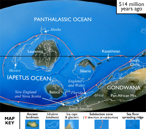
(Pannotia, 514 MYA)
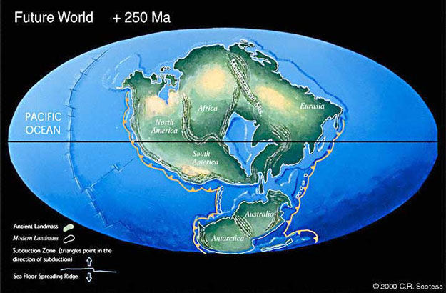
(Pangaea Ultima, 250 MYA to the future!!!)
These are only a few maps of all I have. If you accept colaborate, We´ll speak about the map you want, and I´ll send you all you need.
I have: Rodinia, Gondwana, Pannotia, Vaalbara, Kenorland, Pangaea, Pangaea Ultima, Nena, Laurasia, and Columbia Supercontinet
I´ll do Rodinia map.
65 millons of years ago I had an idea
:I have a lot of ancient Earth maps (10 millons of years ago, 50 millions, 65, 100, 150, 250, etc... with its contintents and references to the actual continents.
If you want, we can create Earth Ancient maps to be played in BTS, with its starting locations (for example, in Pangaea Map, Spain and USA would begin very close, incas will be next to zulues
, and India will be and island....Well, I´ll post here a few maps, I hope you´ll join to this project. We can do them in the same size, and join all in a unique pack called "Ancient Earth Ages" to allow the people to play all of them.
OK??
(Rodinia, 1270 MYA)
(Pannotia, 514 MYA)
(Pangaea Ultima, 250 MYA to the future!!!)
These are only a few maps of all I have. If you accept colaborate, We´ll speak about the map you want, and I´ll send you all you need.
I have: Rodinia, Gondwana, Pannotia, Vaalbara, Kenorland, Pangaea, Pangaea Ultima, Nena, Laurasia, and Columbia Supercontinet
I´ll do Rodinia map.