Guess the Map V: A Map is Worth a Thousand Words

Value of stock exchange?
 
Nevermind, not enough countries to be exchanges. Even Namibia has a little exchange.
 
Just a few educated guesses:...

Percent of foreign population?
Poverty rate?
Private vs public education ratio?
Amount of schooling years required?
Number of wars won?

Also, image repost:

Spoiler :
attachment.php
 
Cost of electricity or some other utility?
 
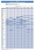
PISA results from 2009? For....Math?

Aww Man, first you guys don't let me place the Angie tipp, and now I don't get to post that picture as the next clue:

images


Anyways, you are correct. How did you get it so exact and out of the blue (other clues)? Was the Shanghai-data the clue that it has to be the PISA test? And how did you know 2009? Math is of course fairly obvious (Asians = good in math-stereotype).

Here's the Chart I took it from (it's the German version but I guess the names are fairly obvious as they are the same, it's the second column from the right):

attachment.php


The Categories were:

Dark Blue: 600-575 (Shanghai)
Light Blue: 574-550
Dark Green: 549-525
Light Green: 524-496
Yellow: 495-450
Orange: 449-400
Red: 399-350
Brown-Red: 349-300 (Kirgistan)

Congratulations to Algeroth.
 

Attachments

  • PISA.jpg
    PISA.jpg
    317.9 KB · Views: 163
Anyways, you are correct. How did you get it so exact and out of the blue (other clues)? Was the Shanghai-data the clue that it has to be the PISA test? And how did you know 2009? Math is of course fairly obvious (Asians = good in math-stereotype).

When someone tried to guess that the map have something to do with education, It just jumped into my head that PISA tests are the only statistics that I know where Chinese special economic zones are treated as separate territories. And that Shanghai did really well in the last PISA. After that, I just checked Wiki for the results and math was the only subject where Switzerland, Finland and Netherlands placed nearly as high as the East Asia.

Give me an hour to come up with something.
 
Ok, this shouldn't be hard.

Blue is the lowest, red the higest.
Some countries are painted with two colours because of the breakup of USSR.

14y0goh.png
 
Am I right in assuming that Hokkaido, Kyushu, and Shikoku are supposed to be yellow along with Honshu? Or is that somehow part of the USSR breakup thing?
 
Am I right in assuming that Hokkaido, Kyushu, and Shikoku are supposed to be yellow along with Honshu? Or is that somehow part of the USSR breakup thing?

Oh, dammit. I got bored with colouring the islands and territories and totally forgot about Japan. The answer is no, its my mistake, the information relates to states, not territories.
 
Back
Top Bottom