Hurricane Gustav

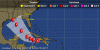
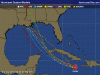
Oh please, not another repeat of 2005. Please, no.

Oh boy here we go again with New Orleans.

Its ok. They now have a republican governor who is already declaring a state of emergency.

No more flooded busses this time. http://www.msnbc.msn.com/id/26425142

Plans for mandatory evacuation
If a Category 3 or stronger hurricane comes within 60 hours of the city, New Orleans plans to institute a mandatory evacuation order. Unlike Katrina, there will be no massive shelter at the Superdome, a plan designed to encourage residents to leave. Instead, the state has arranged for buses and trains to take people to safety.

Duh...if they had only done that last time....
 
Perhaps McCain will have an ever bigger birthday cake this time around to tempt New Orleans residents to leave the city and join him.
 
Its ok. They now have a republican governor who is already declaring a state of emergency.

No more flooded busses this time. http://www.msnbc.msn.com/id/26425142

Duh...if they had only done that last time....

Hallelujah. Not on the Republican thing (the mayor is on the job, too), but on the fact that they're being proactive on the whole thing.

In other news, there is another hurricane in formation in the Atlantic, one that may head toward the east coast.
 
750px-2008_07L_5-day_track.gif


Current projection has it moving to the West.
 
Its ok. They now have a republican governor who is already declaring a state of emergency.

Yeah at least the head of FEMA isnt a "horse judge"
 
The latest spaghetti model is below. Mobile, Alabama to the central Louisiana coast seems to be the target area. The NHC has it coming ashore as a category 3. Still, landfall is days away, and things could change.
 

Attachments

  • spaghettimodel3.GIF
    spaghettimodel3.GIF
    46.2 KB · Views: 85
Current projection has it moving to the West.

You shouldn't use wikipedia for this, as that image keeps getting changed with updates. Thus every projection map you've posted is the same.
 
Quasar, you're the meteorologist, what should we expect from Gustav?
In my experience, the hurricane center does a better job with the forecast track, than with the landfalling intensity. I remember Hurricane Charley in 2004 suddenly strengthening to a category 4, just before it struck the coast south of Tampa. Other storms have lost intensity right before landfall (thankfully!) I still want to see what the water temperatures are this weekend just south of the Central Gulf Coast- that ought to be key as to whether Gustav does strenghten past cat 3.

By the way, Tropical Storm Hanna has now formed.
 
Thank goodness that Obama will be President soon, so that we can create the meteorological opportunities beyond our borders that will disuade hurricanes from entering our territory.

:cheers: I knew you'd come around.
 
The latest chart from channel 8 in Tampa, showing forecasted positions and intensities for Gustav:
 

Attachments

  • Thuchannel8fcst.GIF
    Thuchannel8fcst.GIF
    27 KB · Views: 113
The latest chart from channel 8 in Tampa, showing forecasted positions and intensities for Gustav:
 
You shouldn't use wikipedia for this, as that image keeps getting changed with updates. Thus every projection map you've posted is the same.

Poopage, good catch.
 
Tropical Storm Gustav Discussion Number 17
Nws Tpc/national Hurricane Center Miami Fl Al072008
1100 Pm Edt Thu Aug 28 2008

The Center Of Gustav Has Been Moving Near Or Over The South Coast Of
Jamaica During The Evening. Surface Observations From The Kingston
Area Showed Winds Of Tropical Storm Force...and The Lowest Observed
Pressure Was 990 Mb. Gustav Is Producing A Large Area Of Cold
Convective Tops Near And East Of The Center...with Satellite
Intensity Estimates Of 65 Kt From Tafb And 55 Kt From Sab. The
Initial Intensity Remains 60 Kt.

The Initial Motion Is A Somewhat Uncertain 270/6...after A South Of
West Motion For A Few Hours. Gustav Is On The South Side Of A
Mid-level Ridge Over Florida And The Adjacent Western Atlantic.
The Dynamical Guidance Forecasts Gustav To Turn Northwestward On The
Southwest Side Of The Ridge During The Next 48 Hr...then Continue In
A General Northwestward Direction Through 96 Hr. The Guidance Is
Rather Tightly Clustered During This Time Period. After 96
Hr...there Is Some Spread...as The Dynamical Models Do Not Agree On
Whether A Ridge Will Build To The North And West Of Gustav. The
Gfdl Moves The Storm Quickly Inland...while The Latest Gfs Run
Shows It Slowing Down Over Southern Louisiana. The Nogaps Calls
For A Left Turn After 96 Hr Toward The Texas Coast. The New
Forecast Track Is An Update Of The Previous Package That Is Down
The Middle Of The Guidance Envelope. The Track Is Shifted Only
Slightly To The Left After 72 Hr....with Reliable Model Forecasts
Remaining On Either Side Of The Track. since Track Forecasts Are
Always Subject To Large Errors At 3-5 Days...it Is Simply
Impossible At This Time To Determine Exactly Where And When Gustav Will Make Final Landfall.

The Intensity Forecast Is Problematic. Gustav Is Showing Good
Outflow In All Directions At This Time...but There Is Evidence Of
Northerly Vertical Shear Undercutting The Outflow. The Large-scale
Models Suggest This Should Subside In About 24 Hours...which Would
Allow Significant And Possibly Rapid Intensification Over The Warm
Waters Of The Northwestern Caribbean. A Complicating Factor Is The
Upper-level Trough Currently Seen In Water Vapor Imagery Over The
Gulf Of Mexico. The Large-scale Models Forecast This Feature To
Retreat Westward As Gustav Approaches...with High Pressure Building
Over The Southeastern Gulf. However...the Models Do Not Agree On
How Much The Trough Will Move...with The Ukmet In Particular
Showing The Possibility Of Shear As Gustav Approaches The Northern
Gulf Coast. The Ships Model Calls For A Peak Intensity Of 99
Kt...the Lgem Model 94 Kt...the Gfdl 111 Kt...and The Hwrf 137 Kt.
The Latter Is Definitely Not Out Of The Question. The Intensity
Forecast Is Increased Over The Previous Forecast In Best Agreement With The Gfdl. however...it Would Be No Surprise If Rapid Intensification Occurred And Gustav Became A Category 4 Or 5 Hurricane By 72 Hr.
Forecast Positions And Max Winds

Initial 29/0300z 17.8n 77.3w 60 Kt
12hr Vt 29/1200z 18.3n 78.6w 60 Kt
24hr Vt 30/0000z 19.1n 80.4w 75 Kt
36hr Vt 30/1200z 20.4n 82.3w 90 Kt
48hr Vt 31/0000z 21.9n 84.2w 100 Kt...near Coast Of Cuba
72hr Vt 01/0000z 25.5n 87.5w 110 Kt
96hr Vt 02/0000z 28.5n 90.5w 100 Kt
120hr Vt 03/0000z 30.0n 92.5w 90 Kt...inland

$$
Forecaster Beven
 
however...it Would Be No Surprise If Rapid Intensification Occurred And Gustav Became A Category 4 Or 5 Hurricane By 72 Hr.

Category 5 Hurricane would be the same strength as Katrina ?
And it looks like its going to hit NO again to boot
 
If New Orleans gets hit again, the damned city should just be abandoned. We shouldn't waste anymore tax money just so people can go back to a damned city that happens to be under sea level AND is a hurricane target.

So is Miami, Mobile and Houston, Baltimore, New york city.... think before you post. All of those cities can be effected by hurricanes and have at some point in there past. Any city on the atlantic coast is subject to hurricanes


You like the way things work in the USA. You know things like gas in the pumps, bread on your table. With out the PORT OF NEW ORLEANS...as much as 20 percent of imports would have to be rerouted. The majority of your imported oil comes in to a little place called Port Fourchon at the LOOP oil facitlity.

As far as Louisianan goes, there are plans in place and things are going to plan. Take that for someone who has been working getting things done in my small section of resposibility on the states plan. IF it hits I will post back in OT about on the ground happening in Search and rescue.

Woudl you support tax dollars to rebuild the midwest after tornadoes/floods or perhaps California after earthquakes/fires.
 
So is Miami, Mobile and Houston, Baltimore, New york city.... think before you post. All of those cities can be effected by hurricanes and have at some point in there past. Any city on the atlantic coast is subject to hurricanes

Is every city on the Atlantic seaboard below sea-level? Think, McFly, think!

Regarding your rebuilding strawman, yes I would. Just as I would support rebuilding other cities in coastal areas THAT ARE NOT BELOW SEALEVEL.
 
Category 5 Hurricane would be the same strength as Katrina ?
And it looks like its going to hit NO again to boot

Katrina was a category 5 hurricane while still over water. It came ashore as a cat 4.

It could hit near New Orleans, yes; but it could also hit elsewhere. Some models have it coming ashore as a cat 2 or 3. Trouble is, the models may not have a handle on the projected rapid strengthening this weekend. The official forecast still calls for Gustav to peak at category 3. But the official track also has it crossing western Cuba, which could weaken the storm a bit. The key day will be Sunday, when its path will be completely over water. By sundown Sunday, we ought to have a grasp on how strong the storm will be. After all, Gustav has not yet been above cat 1. Water temperatures in the Gulf of Mexico will be key.
 
Nice to see that you're still around Quasar. I still remember the Katrina thread unfolding on these boards as it slid into the gulf.
At least I only watched Katrina from afar. In 2004, I was living in Mobile, Alabama, and had to live through a major hurricane. Hurricane Ivan thread I was on duty at the weather station for 30 straight hours until someone could get in to relieve me. Needless to say, I took the first transfer outta there; and now live in sunny California, where I miss real weather, but all I have to deal with is an occasional earthquake.

By the way, my avatar is from post 28 of the Hurricane Isabel thread back in 2003; Isabel was a category 5 storm at that time.
 
Back
Top Bottom