You are using an out of date browser. It may not display this or other websites correctly.
You should upgrade or use an alternative browser.
You should upgrade or use an alternative browser.
NES World/Regional Maps II
- Thread starter Chieftess
- Start date
- Status
- Not open for further replies.
North King
blech
- Joined
- Jan 2, 2004
- Messages
- 18,165
Hm.... That actually is the whole world, jalepeno... The southern continent is sort of a cross between a Canada and a Antarctica, though I do realize that it could use some more interesting coastlines... As for a island subcontinent, that might be interesting... I'll see if I can fit that in. I think I see the perfect area. ")
jalapeno_dude
AKA Panda Judo Eel
Okay. Then I'd at least suggest you blow the map up. If you're planning a fresh start NES, then you're going to need more space.
Reno
The Studio Ghibli Fanatic
Reno
The Studio Ghibli Fanatic
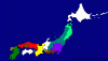
stalin006 said:you are missing the Takeda clan my fav in the map. plus the green guys in the north should be larger
No,
 The Takeda are brown in this map. Look closer. and i added the Date Clan wich is the Teal one in the north.
 ")
Oruc
Reactionary
who are the date?

Reno
The Studio Ghibli Fanatic
stalin006 said:but isnt the north light green clan half the size it should be?
The Teal (Light Green) is the Date clan wich was not in Shogun Total War, i added it to the map to make it have 8 players instead of 7.

Reno
The Studio Ghibli Fanatic
Hurray! You got the border of Finland correctly, and rest of the map looks good and correct too. 
Insane_Panda
Deity
Hopefully sheep will use this map for his NES.
Great stuff erez
Great stuff erez
Insane_Panda
Deity
Coming up next:
PANDA WORLD MAP!

![[party]](/images/smilies/partytime.gif "Party [party]")
PANDA WORLD MAP!
North King
blech
- Joined
- Jan 2, 2004
- Messages
- 18,165
Uh oh. It's going to be like bigger, better, and somehow smaller all in one, isn't it?
Insane_Panda
Deity
Maybe...Or it might just suck.
erez87
Lord of Random
- Joined
- May 16, 2002
- Messages
- 13,500
Cold war map! 1950! (germany free or un free but it's occupied anyway)

Galaxy1!
Just a black map with lots of whites

And Galaxy2! I'm actualy proud of this one I like my black hole  the gray circle means the huge sucking powers of the black hole....The map also looks better that the gaalxy above, show suns and planets around them.

Galaxy1!
Just a black map with lots of whites
And Galaxy2! I'm actualy proud of this one
I like my black hole the gray circle means the huge sucking powers of the black hole....The map also looks better that the gaalxy above, show suns and planets around them.
Insane_Panda
Deity
Whoa erez, nice map. Personally though, I don't really like the black hole.
- Status
- Not open for further replies.
Similar threads
- Replies
- 3
- Views
- 560
- Replies
- 3
- Views
- 873