You are using an out of date browser. It may not display this or other websites correctly.
You should upgrade or use an alternative browser.
You should upgrade or use an alternative browser.
NES World/Regional Maps II
- Thread starter Chieftess
- Start date
- Status
- Not open for further replies.

World map with rivers and 1936 Nations and Borders
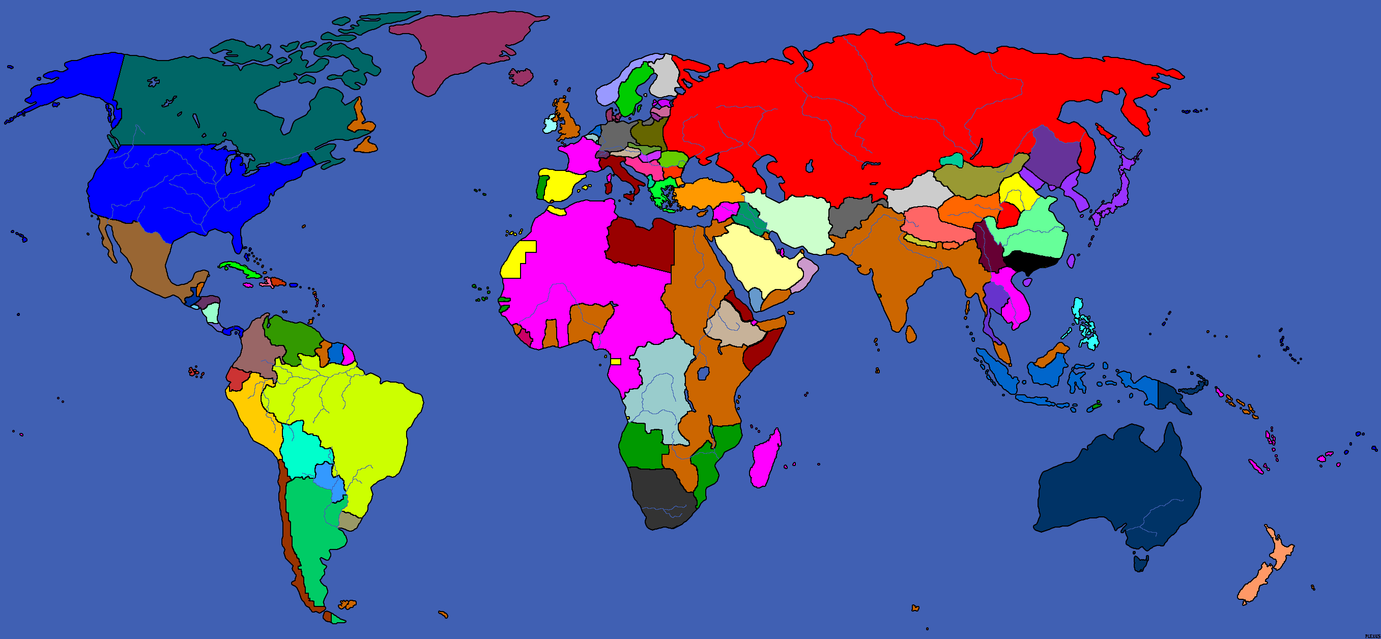
Kudos to:
Plexus for the creation of the basis of this map
Hellfury for creating a version of plexus map with Rivers
Erez87 for creating a version of plexus map with 1920-1930 Nations and Borders
Fëanor (me!) for changing the Borders those of 1936 and a couple of dozens small details
Kudos to:
Plexus for the creation of the basis of this map
Hellfury for creating a version of plexus map with Rivers
Erez87 for creating a version of plexus map with 1920-1930 Nations and Borders
Fëanor (me!) for changing the Borders those of 1936 and a couple of dozens small details
Gelion
Retired Captain
That looks great!
Plexus
Architeuthidae puericomedentis
Awesome adaptation of my map. 
") ?
?Drake Rlugia
....
I'm currently working on a story set in the Post-WW1, with the Centrals winning the war. I decided to do a map, and then later I added some cities. Borders may be off a little, but I tried my best(I'm pleased with Africa, I think I got it's borders correct)
If you want to use it for an NES, I'll warn you. Many small/useless nations have been merely absorbed into larger ones, for playablity sake. So Mexico dominates Central America, and Panama is American, and only 6 nations in South America. The Balkans are split between Austria-Hungary/Ottomans, but that is intended, and central Asia is split between Persia, British India, and Russia.
It's completely ready to be used for whatever you need, but I feel I might of misplaced Moscow and the Chinese Capital(Nanjing I think?). The date for this would be 1918, just after the Treaty of Berlin was signed, ending WW1. That's..about it. Enjoy, and please note it is an Alternate history.
(Edit - Map on page 15.)
")
Drake Rlugia
....
And it is. o_o
The Malay tip is red, and red is British. It should be correct.
The Malay tip is red, and red is British. It should be correct.
Drake Rlugia
....
Well that would make sense.
Fixed. Also gave the Germans Borneo.
Fixed. Also gave the Germans Borneo.

Insane_Panda
Deity
dangit, new map! Now I need to do some overs again.... Or cut and paste..
Insane_Panda
Deity
@Drake: Yes, Nanjing is off, but Berlin is way off too.
Insane_Panda
Deity
Also, you have no Austria. Vienna is in german hands on your map, and that big balkan nation that is supposed to be austria hungary is actually hungary - you put its capital at budapest.
Drake Rlugia
....
Ack, will fix that. Where is Nanjing and Berlin at, I figure Berlin is more west, but I have no idea on Nanjing..
Drake Rlugia
....
Fixed version. Berlin moved more west, Austria given Austria, Borneo and Signapore to Germany. Austrian capital moved from Budapest to Wien. It's probally still not right, but still, it's an improvement. Will address Nanjing when I actually know where's at.
(Edit - Map on page 15)
(Edit - Map on page 15)
Oruc
Reactionary
wheres Bulgaria? they were on central powers side
das
Regeneration In Process
Nice, Feanor, but Czechoslovakia looks rather odd in the western part of it.
Drake - looks very... unlikely. What was the PoD? Also, true with Bulgaria.
Drake - looks very... unlikely. What was the PoD? Also, true with Bulgaria.
Drake Rlugia
....
@Emu - I was in favor of absorbing tinier nations into larger ones just for simplicity.
@Das - It's in 1914, when the Germans use Schlieffen Plan. They don't lose the battle of Marne against the allies due to better preperations, and are able to reach Paris.
@Das - It's in 1914, when the Germans use Schlieffen Plan. They don't lose the battle of Marne against the allies due to better preperations, and are able to reach Paris.

- Status
- Not open for further replies.
Similar threads
- Replies
- 3
- Views
- 618