RFC:Antiquity Map Development Thread

I think those are too much. And you must take into account core areas and spawning zones from different civs can never intersect each other.

Is it safe to assume we're all OK with the following core civs (grouped by cultural group, sorta):

Egypt
Babylon, Assyria, Hittites
Hebrews/Jews, Phoenicians, Carthago
Persians
Athens, Sparta, Macedonia, Rome

Those are 12 civs, having in mind they endured at least for some time and it would make sense for them to respawn (even if with other name) later. So the map must give plenty of land for all of them. I think with kravixon's WBsave and the proposals in this thread that is assured.

Now, about the others.

Sumer, Akkad, Phrygeans, Urartu: very shortlived; I'd only have the first one and never allow it to respawn.

Chaldea, Elam, Juddah, Lydia, Medea, Seleucids, Parthia...: those aren't just entities by themselves; I know they were different than others but they can surely be merged with the core ones.

Another greek one, Syracusae, Pergamum...: as I said, I see a problem having Sparta, Athens and Macedonia in Greece. None of them is supposed to colonize the Mediterranean. Athens, if we strecht it, only a little. So I propose an Asia Minor-coastal one. You can dinamically call it Lydia, Pergamum, or whatever.

Early Barbarians: I just liked how celts were portrayed in RFC. Don't think they should appear, just because they're not supposed to be civilized the same way as the other civs. Separate tech tree? Forbidden workers? Dunno. Just don't like them enough. They're already controllable with scripted events. In any case, no gauls, britons, etc. Just celts.

Germanic tribes: those could be in the very late game, but I still prefer the RFC approach for all barbarians and "natives".

In that respect, I don't think the game should end at 476. Seems too late for me. Could be 200 AD or something like that.

Another thing to consider: although Rhye implemented the dynamic civ names and change of personalities, I think it could be interesting to dinamically change a civ when it respawns, changing its name, leader AND UHV and unique power, depending of the current period. And making them accesible from the start scenario window.

Know what I mean?
 
Athens represents Athens itself and its allies. Same for Sparta. With that in mind, we can have them colonize Black Sea, Anatolia, southern Italy, southern France, and eastern Spain.

The ones that are undeniable I put on post 15. The others are suggested, and I don't want to exclude anyone's suggestion because it is not my choice alone. It is the community's, so thanks for your input. Judea is controversial. I thinks it's a main Mesopotamian civ, but others think it was too short lived.

Sumeria could have many turns alone as one of the starting civs. It has room to have multiple cities and we can have a City-State civic.

I think Celts should just be a computer civ.

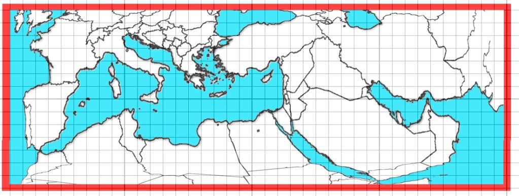
Updated Reference Map.
Spoiler :

-Expanded Mediterranean
-Give Italy, Greece, and islands more space. More playing room + room for Malta)
-Added Grid
 
Been playing a bit with the BMPtoWBSConverter, and before anything else I adapted my proposal to a BMP and edited it a bit.


As you can see, the tiniest islands are exactly 1 tile.

I think Greece is big enough. It even allows another greek civ in Crete (minoans, which could be "mixed" with mycenae and settle proper Peloponessus).

Anatolia can support a greek civ in the west coast, Hittites and even another one east or north of that.

Edit: it's 205x75 tiles, by the way.
 
I like it. All our ideas are meshing like cultural diffusion! Ahh.. most important word in 9/10th grade global... ahh...

Well, I started my FIRST map ever, and I'm pretty excited about it. I did the east until Anatolia (Anatolia looks like crap! But I think everything else is nice.) I have everything in plains, and finally taught my self how to use the river tool. Jedi, do you know how to upload a WB save or a regular save?
 
Personally I wouldn't take such a large map. 205 x 75 not only means longer loading times, but less wars as well. There are more than 50 tiles between Persia and any Greek civ, which is way too much. So I'd suggest to scale the map down to something around 80 x 40.
 
RFC is 124x68; RFCEurope 100x73.

80x40 seems too small for me. Having 75 tiles vertically is OK.

Can try to squeeze it horizontally to 125x75. It will still be a bit bigger than those, but have in mind it's not just the size of the map, but the number of cities which makes it longer to load. Arabia, the Sahara and denses forests in Europe won't be settled.

As for the distance between Greece and Persia, the latter is supposed to conquer a lot. And yes, they're really that far in the world. I've already thought units movement and roads movement bonus have to be drastically increased anyway.
 
I know, but I think that it takes ages to move armies over such a large map. Large areas remain unsettled because of natural limits, and some because the map is quite large. In RFC things were a bit different IMO, since large parts of the map are oceans, and many of the others are supposed to be empty (like the Pacific Islands, some parts of Africa, SA, NA and Siberia), so the productive area is actually rather small. I like the shape of the map, but it is simply too big. New players (me included) probably want to recreate historical empires, and that's only possible with: A) enough cities so there are no large gaps, and B) Enough time to conquer everything. I understand that Caesar's and Alexander's conquests are not possible in civ, but a Persian empire all the way to Byzantium should be possible.
 
Cities can be set to be at least 3 tiles apart, and maintenance costs lowered.

Units can have 2 movements instead of 1, and roads multiply x3 instead of x2.

It's just not possible to have a map from Hispania to the Indus valley with a huge Greece and space for the aforementioned civs if it's any less than, say, 125x75. Even like that it's pushing it a bit.

The goal of this mod BTW should be to make Caesar's and Alexander's conquests possible.
 
I like it. All our ideas are meshing like cultural diffusion! Ahh.. most important word in 9/10th grade global... ahh...

Well, I started my FIRST map ever, and I'm pretty excited about it. I did the east until Anatolia (Anatolia looks like crap! But I think everything else is nice.) I have everything in plains, and finally taught my self how to use the river tool. Jedi, do you know how to upload a WB save or a regular save?

Upload to a comment, you mean? Hit advanced and add it as an attachment. Better if compressed with zip.

BTW I don't recommend using WB from the very beginning.

Edit: 125x70 tiles


Some of the proposed forbidden areas for settling cities (Egypt is narrower than that):

 
I think it might be too big too, but we'll have to see. While maintenance costs can be lowered an such to allow more cities, each city increases loading times. If you could get it up to the point of a worldbuilder save, it'd be easier to get a feel for the size.

Geography-wise, it looks good, however Sicily and Crete seem much too large and Crete is rather the wrong shape. I'd also make the "heel" of Italy's boot shape a little narrower.

I would also make the Hellespont and the Bosporus straights connected and place a river where the water would be, for game play reasons. That will allow Alexander and Xerxes to be able actually able to cross it for a land invasion.
 
EDIT: NVM Learned how. Thanks Jedi.
What I did was I made Kravixon's map completely ocean and added a grid and saved it as anew. So for my map is 52* vertical. I didn't do the west so I don't know the horizontal. Also, no matter whose map we use, we must remember the Persian Gulf used to be longer and the Tigris and Euphrates weren't connected in ancient times..

*I said 75 by mistake
 
I like the map, and am no worldbuilder wizard, but I wonder if you need all of Iberia. If the Celts aren't going to be playable (honestly, I think they should be, as two seperate civs, but I'm Irish), then you really don't need anything other than a strip from Barcelona to Gibralter. So, I think if you rotate France, Italy, Spain, and England about 35-40 degrees clockwise, cutting down on spain as needed, the map will feel less warped, and have less dead space.
 
This originally started just as the Mediterranean. Then we added the Middle East. To keep this centered around them, we decided it would be best if we compacted places such as Iberia. This way there wouldn't be that much empty space and we could still get a ship from say Phoenicia to the British Isles. This would make trade easier as well.
 
137x50 tiles
That is 80% the number of plots from RFC

Still too big. Huge, I'd say. It's different to see a BMP than the actual WBsave.

kravixon, if you can look at the size and number of plots of Greece right now and propose a lesser number, that'd be great.

I mean, after playing with the generator it's just a matter of making the BMP any size we want.

I'm not sure about the Bosphorus. Closing it means that if Byzantium isn't built or is razed, any city in the Black Sea will be disconnected from Mother Greece.

Wasn't the AI supposed to be better at naval invasions than before?
 

Attachments

  • RFCAScenario.zip
    18.4 KB · Views: 62
View attachment RFCA Zmap v1.0.zip
I think I did it.
Ignore west of mountains, except Africa.

Jedi, I'm gonna post an edit of yours. It will be a compromise between our 3. (you, me, and Krav)

View attachment Jedi Zedit v 1.1.zip

Change Log:
Changed southern Italy, Sardinia, and Sicily..
Trimmed western north Africa to allow more room for Sicily.
Added Malta
Trimmed southern France and western Spain
Created a connected Bosporus Straight and divided with a river.
Spoiler :
I'm not sure about the Bosphorus. Closing it means that if Byzantium isn't built or is razed, any city in the Black Sea will be disconnected from Mother Greece.
But we have to weight pros with cons.
Pros:
-land routes between Europe and Africa/Asia
-trade available with River.
Cons:
-are no ships allowed to pass if there is no city. But we can edit settler maps for multiple civs to make it a priority.


Added mountain line to divide map. (I'll do the Middle East, as I like your Mediterranean and my Middle East.)
Added mountain arrow to show that we should make Africa go lower (see my map for details).
 
View attachment 208714


Jedi, I'm gonna post an edit of yours. It will be a compromise between our 3. (you, me, and Krav)


Added mountain line to divide map. (I'll do the Middle East, as I like your Mediterranean and my Middle East.)
Added mountain arrow to show that we should make Africa go lower (see my map for details).

THIS. The "JediZedit" is the best one so far. I'd say that it doesn't need to go any lower at all, any lower and we'd have to include a bunch of useless desert and maybe a Nubian civ.

Pros of the map:
1) it's a pretty good size
2) Spain doesn't look distorted at all, unlike the reference pics
3) Map borders are where I think they should be
4) It looks really good
5) It's a compromise between a lot of our ideas

Cons
1) Some parts of Greece need some minor adjustments
2) I definitely think Sicily should be detached from Italy

In fact, I'll change my two cons and upload the file. I think this is getting pretty legit.
Edit: my file is uploaded. The Peloponnese looks a lot more like it should, and it will give a little more breathing room between Athens and Sparta. Check it out.
 

Attachments

  • myfixes.zip
    22.3 KB · Views: 52
Cool.I'll do east of the border by Friday at least.
The things I like most about my map are:
-Egypt (little distorted Nile Delta)
-Persian Gulf
-Gulf of Aden
 
Top Bottom