silver 2039
Deity
- Joined
- Jul 26, 2003
- Messages
- 16,208
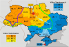
Well they obviously had the benefits of superior German development, industrialization, and education.
All the Germans got kicked out of the German parts of Poland at the end of World War II, the article accompanying that map explained that wasn't the cause (they weren't sure what if anything was).
That was my first thought too.Well they obviously had the benefits of superior German development, industrialization, and education.
") It just seemed pretty amazing to me.
It just seemed pretty amazing to me.Well they obviously had the benefits of superior German development, industrialization, and education.

I blame Gallic persons and take the opportunity to cleanse the local area of them whenever possible.I hate that there's a Galicia in Spain, a Galicia in Eastern Europe, and a Galatia in Anatolia

I see you split Belgium in two, but did you also add some parts of The Netherlands to Flanders? (ie parts of Zeeland and Limburg that were originally Belgian between 1830 and 1839)?Can anyone tell me any cities which would be near MY maps northern Urkaine boundry? i'm having a hard time placing it...
I think I have a vague idea of why Belgium was split up, which wouldn't involve the Dutch giving up any territory. But it's his to reveal.I see you split Belgium in two, but did you also add some parts of The Netherlands to Flanders? (ie parts of Zeeland and Limburg that were originally Belgian between 1830 and 1839)?
Interesting map...

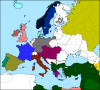
This is pretty unbelievable:

Polish 2007 election results with pre-WW2 German borders superimposed.
That was my first thought too.
I didn't yet actually take the time to form a serious hypothesis to explain this.
Look! An Altered map! Sort of!
Place names translated directly into English.

Damn, I want to see the Czech Rep.!
Prague = Door-step town


 ) That's great.)
This is pretty unbelievable:
Polish 2007 election results with pre-WW2 German borders superimposed.